Lehigh Gap facts for kids
Quick facts for kids
Lehigh Gap
|
|
|---|---|

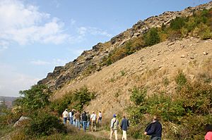
The Shawangunk Formation at Lehigh Gap in October 2008
|
|
| Region | Lehigh Valley |
| State | Pennsylvania |
| Country | United States |
The Lehigh Gap is a special place in eastern Pennsylvania. It's a "water gap," which means a river has cut through a mountain range. Here, the Lehigh River flows right through the Blue Mountain. This natural opening makes it much easier to travel between different areas.
The gap is located where four townships meet: Lehigh, Washington, Lower Towamensing, and East Penn. It connects Carbon County to the north with Lehigh and Northampton counties to the south. One cool feature you can see is a rock formation called Devil's Pulpit, which looks like a church pulpit. There's also a small village at the south end of the gap, once known as Weider's Crossing.
Contents
Exploring Lehigh Gap
Lehigh Gap is a busy place for both cars and hikers. It's an important pathway through the mountains.
Getting Around the Gap
Many people drive through Lehigh Gap every day. PA Route 248 goes right through it. This road links cities like Allentown and Bethlehem to smaller towns like Palmerton and Lehighton. Other routes, PA 873 and PA 145, also connect nearby.
Besides cars, the gap is a key spot for hikers. The famous Appalachian Trail passes through here. Hikers on this long trail find the section at Lehigh Gap to be a challenging rock scramble with open views. Another trail, the Delaware and Lehigh Heritage Corridor Trail, also crosses through Lehigh Gap.
Trains Through the Mountains
For many years, trains have used Lehigh Gap to cross the Blue Mountain. Several railroad companies once had tracks here. The Lehigh and New England Railroad even had a bridge over the Lehigh River in the gap. This bridge was taken down in 1967, but you can still see its old foundations.
Today, the main train line through the gap is called the Lehigh Line. It's owned by Norfolk Southern Railway. Another company, Canadian Pacific Railway, also uses these tracks to reach big cities like Philadelphia and New York City. This shows how important Lehigh Gap is for moving goods and people by train.
Protecting Nature at Lehigh Gap

In 2002, a group called the Wildlife Information Center bought over 750 acres (about 3 square kilometers) near Lehigh Gap. They later changed their name to the Lehigh Gap Nature Center. Their main goal is to help bring back wildlife and plants to the area.
For many years, from 1898 to 1980, a company released a lot of pollution into the air. This pollution harmed plants and animal homes. Even decades later, you can still see fewer trees on one side of the gap because of this past damage.
The Lehigh Gap Nature Center is working hard to fix this. They have a building called The Osprey House on the Slatington side of the river. The center partners with colleges to study wildlife. They also have clubs for young naturalists, which are great for kids who love nature! The center offers about 15 miles of hiking trails that are open to everyone from morning until evening. It's a wonderful place to learn about and enjoy nature.
 | John T. Biggers |
 | Thomas Blackshear |
 | Mark Bradford |
 | Beverly Buchanan |

