Slatington, Pennsylvania facts for kids
Quick facts for kids
Slatington, Pennsylvania
|
||
|---|---|---|
|
Borough
|
||
|
||
| Nickname(s):
The Slate Capital of America
|
||

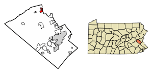
Location of Slatington in Lehigh County, Pennsylvania (left) and of Lehigh County in Pennsylvania (right)
|
||
| Country | ||
| State | ||
| County | Lehigh | |
| Settled | 1737 | |
| Established | 1864 | |
| Government | ||
| • Type | Mayor–council | |
| • Body | Slatington Borough Council | |
| Area | ||
| • Borough | 1.38 sq mi (3.57 km2) | |
| • Land | 1.32 sq mi (3.42 km2) | |
| • Water | 0.06 sq mi (0.15 km2) | |
| Elevation | 490 ft (150 m) | |
| Population
(2010)
|
||
| • Borough | 4,232 | |
| • Estimate
(2019)
|
4,307 | |
| • Density | 3,260.41/sq mi (1,258.92/km2) | |
| • Metro | 865,310 (US: 68th) | |
| Time zone | UTC-5 (EST) | |
| • Summer (DST) | UTC-4 (EDT) | |
| ZIP Code |
18080
|
|
| Area code(s) | 610 | |
| FIPS code | 42-71144 | |
| Primary airport | Lehigh Valley International Airport | |
| Major hospital | Lehigh Valley Hospital–Cedar Crest | |
| School district | Northern Lehigh | |
Slatington is a small town, called a borough, located in Lehigh County, Pennsylvania, United States. In 2010, about 4,232 people lived there. Slatington is found northwest of bigger cities like Allentown and Bethlehem. It is part of the Lehigh Valley area, which has a population of over 860,000 people.
Contents
History of Slatington
The first European settler in the Slatington area was Nicholas Kern in 1737. Before that, the Lenape Native Americans lived there, using a path called "Warriors Path." This path is now Route 873. Nicholas Kern built a sawmill soon after he arrived.
In 1756, Benjamin Franklin even got wood from Kern's sawmill. Later, in the 1800s, two men from Wales discovered slate in the area. They knew how important slate was from its use in Europe. A slate quarry, which is a place where slate is dug out of the ground, opened in 1845. A factory to process the slate was built in 1847.
In 1864, Slatington officially became a borough in Pennsylvania. Its first mayor was Robert McDowell. In the past, Slatington was known for making things like iron, knit goods, and silk. But it was most famous for its many slate quarries.
In 1900, 3,773 people lived in Slatington. By 1910, the population grew to 4,454. The population has stayed around 4,200 people since then. The ZIP code for Slatington, PA is 18080.
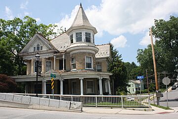
In 2010, two important places in Slatington were added to the National Register of Historic Places. These were the Fireman's Drinking Fountain and the Slatington Historic District.
Geography and Location
Slatington is in the northern part of Lehigh County. It is on the west side of the Lehigh River. Across the river to the east is the town of Walnutport. Slatington is about 14 miles (23 km) northwest of Allentown. It is also 70 miles (113 km) north of Philadelphia.
The borough covers about 1.4 square miles (3.6 square kilometers) of land. A small part, about 0.1 square miles (0.26 square kilometers), is water. The center of Slatington is about 380 feet (116 meters) above sea level. The lowest point is 345 feet (105 meters) at the Lehigh River. The highest point is 742 feet (226 meters) on a hill south of South Street.
Slatington has a nice place called Victory Park. This park has a community swimming pool. It also has a disc golf course and the Angelo J. Scarselletti Amphitheater.
Population and People
| Historical population | |||
|---|---|---|---|
| Census | Pop. | %± | |
| 1870 | 1,508 | — | |
| 1880 | 1,634 | 8.4% | |
| 1890 | 2,716 | 66.2% | |
| 1900 | 3,773 | 38.9% | |
| 1910 | 4,454 | 18.0% | |
| 1920 | 4,014 | −9.9% | |
| 1930 | 4,134 | 3.0% | |
| 1940 | 4,062 | −1.7% | |
| 1950 | 4,343 | 6.9% | |
| 1960 | 4,316 | −0.6% | |
| 1970 | 4,687 | 8.6% | |
| 1980 | 4,277 | −8.7% | |
| 1990 | 4,678 | 9.4% | |
| 2000 | 4,434 | −5.2% | |
| 2010 | 4,232 | −4.6% | |
| 2019 (est.) | 4,307 | 1.8% | |
| Sources: | |||
In 2010, there were 4,232 people living in Slatington. These people lived in 1,743 households. About 1,190 of these were families. The population density was about 3,355 people per square mile (1,295 people per square kilometer).
Most of the people in Slatington were White (96.23%). There were also smaller groups of African American (1.42%), Native American (0.20%), and Asian (0.38%) residents. About 2.03% of the population was Hispanic or Latino.
Many households (35.7%) had children under 18 living with them. About 48.7% of households were married couples. The average household had 2.51 people. The average family had 3.01 people.
The population was spread out by age. About 27.1% were under 18 years old. About 13.3% were 65 years or older. The average age in Slatington was 36 years.
Education in Slatington
Slatington is part of the Northern Lehigh School District. This school district has two elementary schools. Peters Elementary School teaches students from Kindergarten to second grade. Slatington Elementary School teaches grades 3 through 6.
The district has one middle school for grades 7 and 8. Students in grades 9 through 12 go to Northern Lehigh High School in Slatington.
Transportation
As of 2019, Slatington had about 16 miles (26 km) of public roads. Most of these roads are taken care of by the borough. A smaller part is maintained by the Pennsylvania Department of Transportation (PennDOT).
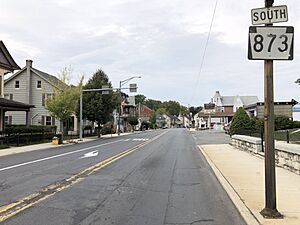
Pennsylvania Route 873 is a main road that goes through Slatington. It runs north and south along Main Street and Walnut Street.
Slatington Airport
|
Slatington Airport
|
|
|---|---|
| Summary | |
| Airport type | Small |
| Serves | Slatington, Pennsylvania |
| Location | Lehigh Valley |
| Opened | May 1957 |
| Focus city for | Allentown/Jim Thorpe |
| Time zone | EST (-5) |
| • Summer (DST) | EST (-4) |
| Elevation AMSL | 380 ft / 116 m |
| Coordinates | 40°45′49″N 75°36′18″W / 40.7635994°N 75.6048965°W |
Slatington has a small airport called Slatington Airport. This airport has one runway. It is used by people who fly small planes and hot-air balloons. The airport is important for the area's safety plans. It could be used to bring in supplies or help people leave during a big natural disaster.
Linear Air, an air taxi company, offers private flights from Slatington Airport. The airport is also home to a local chapter of the Experimental Aircraft Association. Since 2020, the airport has hosted an annual halloween hot air balloon show.
Airport Incidents
On August 21, 1988, a pilot crashed his plane near the runway after its engine stopped working. The pilot was not hurt.
On October 13, 2013, a small plane flipped over on the runway. The pilot had minor injuries.
On July 31, 2022, an EF0 tornado hit Slatington. The airport was damaged. The owner reported that an airplane was tossed and airport buildings were also damaged.
Notable People from Slatington
- Anne Burlak, a leader in workers' rights
- George Hennessey, a former professional baseball player for the Chicago Cubs and Philadelphia Phillies
- Charlie Johnson, a former professional baseball player for the Philadelphia Phillies
- William A. Steckel, an American politician who served in the Pennsylvania House of Representatives
See also
 In Spanish: Slatington para niños
 | Shirley Ann Jackson |
 | Garett Morgan |
 | J. Ernest Wilkins Jr. |
 | Elijah McCoy |


