
Summit Hill, Pennsylvania facts for kids
Quick facts for kids
Summit Hill, Pennsylvania
|
||
|---|---|---|
|
Borough
|
||

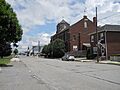
Hazard Street in Summit Hill, July 2013
|
||
|
||
| Motto(s):
"Where it all began"
|
||

Location in Carbon County, Pennsylvania
|
||

Summit Hill, Pennsylvania
Location in Pennsylvania

Summit Hill, Pennsylvania
Location in the United States
|
||
| Country | United States | |
| State | Pennsylvania | |
| County | Carbon | |
| Area | ||
| • Total | 9.11 sq mi (23.58 km2) | |
| • Land | 8.69 sq mi (22.51 km2) | |
| • Water | 0.41 sq mi (1.07 km2) | |
| Elevation | 1,510 ft (460 m) | |
| Population
(2010)
|
||
| • Total | 3,034 | |
| • Estimate
(2019)
|
2,954 | |
| • Density | 339.89/sq mi (131.23/km2) | |
| Time zone | UTC-5 (EST) | |
| • Summer (DST) | UTC-4 (EDT) | |
| ZIP Code |
18250
|
|
| Area code(s) | 570 and 272 | |
| FIPS code | 42-75248 | |

Summit Hill is a small town, called a borough, in Carbon County, Pennsylvania, United States. It is located in a region known as Northeastern Pennsylvania. In 2010, about 3,034 people lived there.
Summit Hill was once the end point of the Mauch Chunk Switchback Railway. This was the second railway ever built in the United States! It was also a very important place for early coal mining in North America. The Lehigh Coal & Navigation Company started mining here in 1792. At first, the town was just a simple camp for miners.
Contents
Discovering Summit Hill's Past

The story of Summit Hill began in 1791. A hunter found a type of coal called anthracite coal on Sharpe Mountain. This mountain is now known as Pisgah Mountain.
The news of this discovery spread quickly. It led to the creation of the Lehigh Coal Mining Company in 1792. This company began looking for coal and buying land. More coal was found in 1794 by Phillip Ginter. It was located on the north side of Pisgah Mountain. This area later became the towns of Summit Hill and Lansford.
The historic Summit Hill High School was added to the National Register of Historic Places in 2001. This means it is a special building recognized for its history.
Where is Summit Hill Located?
Summit Hill is in the western part of Carbon County. It sits on top of Pisgah Mountain. The town's borders stretch far in different directions. They go north to Nesquehoning Mountain and south to Mauch Chunk Mountain. To the east, the borders include most of Mauch Chunk Lake.
The town of Lansford is on Summit Hill's northern border. Tamaqua is on its western border. Tamaqua is in Schuylkill County.
According to the U.S. Census Bureau, Summit Hill covers about 9.1 square miles (23.6 square kilometers). Most of this area is land. About 0.4 square miles (1.1 square kilometers) is water. Summit Hill is about 6 miles (10 km) southwest of Jim Thorpe. It is also 1 mile (1.6 km) south of Lansford. The town center is about 1,510 feet (460 meters) above sea level. The highest point on Pisgah Mountain is 1,620 feet (494 meters) high. The lowest point is 1,010 feet (308 meters) at Mauch Chunk Lake.
People Living in Summit Hill
| Historical population | |||
|---|---|---|---|
| Census | Pop. | %± | |
| 1890 | 2,816 | — | |
| 1900 | 2,986 | 6.0% | |
| 1910 | 4,209 | 41.0% | |
| 1920 | 5,499 | 30.6% | |
| 1930 | 5,567 | 1.2% | |
| 1940 | 5,406 | −2.9% | |
| 1950 | 4,924 | −8.9% | |
| 1960 | 4,386 | −10.9% | |
| 1970 | 3,811 | −13.1% | |
| 1980 | 3,418 | −10.3% | |
| 1990 | 3,332 | −2.5% | |
| 2000 | 2,974 | −10.7% | |
| 2010 | 3,034 | 2.0% | |
| 2019 (est.) | 2,954 | −2.6% | |
| Sources: | |||
In 2000, there were 2,974 people living in Summit Hill. These people lived in 1,291 households. A household is a group of people living together. There were 844 families. Most people living in Summit Hill were White (98.99%).
About 25.3% of households had children under 18 years old. About half of the households (50.1%) were married couples. About 18.5% of households had someone living alone who was 65 or older. The average household had 2.30 people. The average family had 2.86 people.
The population's age was spread out. About 20.1% were under 18. About 22.1% were 65 or older. The average age was 42 years old. For every 100 females, there were about 92.7 males.
The average income for a household was $37,287. For a family, it was $44,500. About 7.5% of the population lived below the poverty line. This included 8.4% of those under 18.
Summit Hill is part of the Panther Valley School District. This district also includes the nearby towns of Lansford, Nesquehoning, and Coaldale.
Getting Around Summit Hill
_at_White_Bear_Drive_in_Summit_Hill,_Carbon_County,_Pennsylvania.jpg)
In 2008, Summit Hill had about 23.53 miles (37.87 km) of public roads. The Pennsylvania Department of Transportation (PennDOT) took care of 9.26 miles (14.90 km) of these roads. The borough itself maintained the other 14.27 miles (22.97 km).
Pennsylvania Route 902 is the main highway that goes through Summit Hill. It follows North Street, Pine Street, Amidon Street, and Laurel Drive. It runs from the northwest to the southeast through the town.
Famous People from Summit Hill
Many interesting people have come from Summit Hill. Here are a few:
- Thomas F. Breslin – A prisoner during the Bataan Death March.
- Francis James Furey – He became an Archbishop in San Antonio.
- Joe Gormley – A player in MLB (Major League Baseball).
- Keith McCall – A former Speaker of the Pennsylvania House of Representatives.
- Samuel McLean – He was a congressman.
- Maria Zuber – A well-known planetary scientist.
Images for kids
-
Hazard Street in Summit Hill, July 2013
-
Seal of Summit Hill
-

Location of Summit Hill in Carbon County, Pennsylvania
See also
 In Spanish: Summit Hill para niños
