
Pisgah Mountain facts for kids
Quick facts for kids Pisgah Mountain |
|
|---|---|
| Highest point | |
| Elevation | 1,611 ft (491 m) |
| Prominence | 500 ft (150 m) |
| Geography | |
| Location | Carbon and Schuylkill counties, Pennsylvania, U.S. |
| Parent range | Appalachian Mountains |
| Topo map | USGS Tamaqua, Nesquehoning, and Lehighton (PA) quadrangles |


Pisgah Mountain or Pisgah Ridge is a long hill in Pennsylvania. It stretches about 12.5 miles (20.1 km) from Tamaqua to Jim Thorpe, Pennsylvania. This ridge runs from the northeast to the southwest. A road called U.S. Route 209 follows the valley on its north side.
The ridge has many peaks that are taller than 1,440 feet (439 m). These peaks rise 300 to 540 feet (91 to 165 m) above towns like Lansford, Coaldale, and Tamaqua. The highest point on Pisgah Mountain is 1,611 feet (491 m) high. It is located in the town of Summit Hill, which sits right on top of the ridge.
Near Summit Hill, a man named Phillip Ginter found anthracite coal in 1791. This discovery led to the start of the Lehigh Coal Mine Company. Later, in 1818, the Lehigh Coal Company took over the mines. The mining camp slowly grew into the town of Summit Hill.
Pisgah Ridge helps separate the water flow for Panther Creek. The peak at the eastern end of the ridge is called Mount Pisgah. It is a hard rock hill that stands 800 feet (244 m) above the Lehigh River to the east.
All the water from Pisgah Ridge eventually flows into the Delaware River. Water from the western part of the ridge's north side flows into Panther Creek. This creek then joins the Little Schuylkill River. Water from the eastern part of the north side goes into Nesquehoning Creek, which flows into the Lehigh River. On the south side, water from the eastern part flows into Mauch Chunk Creek. Water from the western part goes into Owl Creek, which also flows to the Little Schuylkill River.
Mount Pisgah connects with Nesquehoning Mountain near their eastern ends. These two mountains are similar in height. They meet at a 1,540-foot (469 m) summit between Jim Thorpe and Nesquehoning. A very steep valley separates Nesquehoning Mountain from Mount Pisgah. US-209 climbs this valley to reach the Panther Creek valley in Lansford.
Mountain Geology
Pisgah Mountain is a good example of a "ridge and valley" mountain. This means it is one of many parallel ridges formed by the folding of the Earth's crust. This type of landscape stretches from New Jersey all the way to Virginia. It creates a large natural barrier with many valleys.
Pisgah Mountain is located in the southern part of northeastern Pennsylvania's Poconos region. It is also in the heart of the Southern Anthracite Region of Pennsylvania. This area is famous for having the "Richest Anthracite Seam" of coal. This whole region is known as the Southern Pennsylvania Anthracite Field.
The ridge of Pisgah Mountain runs parallel to the Blue Mountain region. However, unlike Blue Mountain, Pisgah Mountain acts as a divide for water. It separates waters that flow southwesterly into the historic Panther Creek.
Images for kids
-
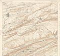
Coal-filled ridges north of Blue Mountain
-
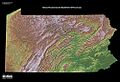
A map showing the hills and valleys of Pennsylvania.
