
Luzerne County, Pennsylvania facts for kids
Quick facts for kids
Luzerne County
|
||
|---|---|---|
|
||

Topographical map of Luzerne County, Pennsylvania
|
||

Location of Luzerne County in Pennsylvania
|
||
| Country | United States | |
| State | ||
| Region | Northeastern Pennsylvania | |
| Metro area | Wyoming Valley | |
| Formed | September 25, 1786 | |
| Named for | Chevalier de la Luzerne | |
| County seat | Wilkes-Barre | |
| Largest city | Wilkes-Barre | |
| Government | ||
| • Type | Council–manager | |
| Area | ||
| • Total | 906 sq mi (2,350 km2) | |
| • Land | 890 sq mi (2,300 km2) | |
| • Water | 16 sq mi (40 km2) | |
| Highest elevation | 2,460 ft (750 m) | |
| Lowest elevation | 512 ft (156 m) | |
| Population
(2020)
|
||
| • Total | 325,594 | |
| • Density | 359.38/sq mi (138.76/km2) | |
| Time zone | UTC−5 (EST) | |
| • Summer (DST) | UTC−4 (EDT) | |
| Area codes | 570/272 | |

Luzerne County is a county in the state of Pennsylvania. It is located in the northeastern part of the state. The county covers about 906 square miles, with 890 square miles of land and 16 square miles of water.
In 2020, about 325,594 people lived here. This makes it the most populated county in northeastern Pennsylvania. The main city and county seat is Wilkes-Barre. Other important towns include Hazleton, Kingston, Nanticoke, and Pittston.
Luzerne County is part of the Scranton–Wilkes-Barre–Hazleton area. This larger area had a population of 555,426 in 2017.
The county was created on September 25, 1786. It was formed from a part of Northumberland County. It was named after Chevalier de la Luzerne, a French soldier and diplomat. When it was first created, Luzerne County was much larger. Over time, parts of it were used to form other counties. These include Bradford, Lackawanna, Susquehanna, and Wyoming counties.
In the 1800s and 1900s, Luzerne County was a major coal mining area. Many European immigrants came to work in the mines. In 1930, the county's population reached its highest point at 445,109 people. Later, many factories and coal mines closed. Like other areas in the Rust Belt, Luzerne County saw its population decrease. However, in recent years, the economy has started to grow again. Now, warehousing (storing goods) is a main industry, replacing manufacturing.
Contents
History of Luzerne County


The Luzerne County Historical Society works to preserve the history of Luzerne County. They collect and share stories about the past. This includes traditions, events, people, and cultures that shaped the region.
Early Years: 18th Century Events
- 1769: The Pennamite-Yankee War began. Settlers from Connecticut and Pennsylvania fought over land claims. These claims were along the North Branch of the Susquehanna River. This area is now known as the Wyoming Valley.
- July 1, 1778: During the American Revolutionary War, Fort Jenkins was a patriot fort. It was in what is now West Pittston. British soldiers, led by Major John Butler, took over the fort. They were helped by about 700 Native Americans. The fort was later burned down. A bridge connecting West Pittston and Pittston City was built in 1928. It was named in honor of Fort Jenkins.
- July 3, 1778: A group of British soldiers and Native Americans attacked the Wyoming Valley. They killed nearly 300 settlers. Today, a monument in Wyoming Borough marks the gravesite of the victims. This event is known as the Battle of Wyoming.
- July 4, 1778: Fort Pittston, in Pittston City, surrendered to the British. Parts of it were destroyed. It was later rebuilt and used until the end of the Revolutionary War.
- September 1778: American Colonel Thomas Hartley led 200 soldiers. They sought revenge for the Wyoming defeat. They burned several Seneca, Delaware, and Mingo villages. These villages were along the Susquehanna River in northeast Pennsylvania.
- September 11, 1780: Captain Daniel Klader and his men were ambushed. They were investigating reports of British loyalist activity. The Seneca nation and loyalists attacked them. 18 of Klader's men were killed. This event is called the Sugarloaf massacre.
- September 25, 1786: Luzerne County was officially formed. It was created from a part of Northumberland County. It was named after Chevalier de la Luzerne. He was the French ambassador to the United States.
Growth and Challenges: 19th Century Events
- September 6, 1869: A terrible mine fire happened in Avondale. This community is in Plymouth Township. The fire killed 110 people.
- June 28, 1896: The Newton Coal Company's Twin Shaft Mine collapsed. This happened in Pittston City. 58 miners died in the accident.
- September 10, 1897: Sheriff James Martin formed a group of armed citizens. They fired on unarmed miners. This event is known as the Lattimer massacre. Luzerne County is known for being the last county where a sheriff legally formed such a group to handle civil unrest.
Modern Times: 20th and 21st Century Events
- 1908–1912: The coal mining industry used many child laborers. The National Child Labor Committee worked to stop this. Their photographer, Lewis Hine, took many pictures. Many of his photos were taken in the mines around Pittston. These photos helped lead to new child labor laws across the country.
- 1915: A mine fire in Laurel Run, Pennsylvania, caused part of the town to be moved.
- June 5, 1919: An explosion at the Baltimore Colliery in Wilkes-Barre, Pennsylvania, killed 92 miners.
- 1930s–1980s: Pittston City became a major center for making clothes. Thousands of workers, mostly women, worked in factories. Many were part of the International Ladies' Garment Workers' Union. This union helped them get better pay and safer workplaces.
- January 22, 1959: The Knox Mine disaster happened in Port Griffith. 12 people died. This event largely ended the coal mining industry in Northeastern Pennsylvania.
- June 1972: Hurricane Agnes caused massive flooding. The areas around Wilkes-Barre were hit hard.
- 2008: The Kids for Cash scandal involved juvenile court judges. They were found guilty of wrongdoing.
- September 2011: Luzerne County experienced major flooding from Tropical Storm Lee. The Susquehanna River reached a record high level. The Greater Pittston, Wilkes-Barre, and Nanticoke areas were most affected.
- January 2, 2012: A new county government was started. The first members of the Luzerne County Council were sworn in. They later appointed the first county manager.
Geography of Luzerne County


Luzerne County covers about 906 square miles. Most of this is land (890 square miles), and 16 square miles is water. The highest point in the county is Cherry Ridge. It is 2,460 feet above sea level. The lowest point is near Shickshinny, at about 512 feet.
The Wyoming Valley is in the northern and middle parts of the county. This valley is mostly flat near the Susquehanna River. It rises from 512 feet to 2000 feet in some areas. The Wyoming Valley stretches from Exeter Township to Salem Township. Cities like Pittston, Wilkes-Barre, and Kingston are in this valley.
The Susquehanna River flows through most of the county. The Lehigh River drains some eastern parts. The Lehigh River also forms part of the county's southeastern border.
Luzerne County has several urban areas. One large area includes cities like Pittston, Wilkes-Barre, and Nanticoke. These were once coal mining communities. Another urban area is Hazleton, in the southern part of the county. Smaller towns like the Back Mountain and Mountain Top are also found here. Outside these urban centers, you can find small farming communities.
Neighboring Counties
Luzerne County shares borders with these counties:
- Wyoming County (north)
- Lackawanna County (northeast)
- Monroe County (east)
- Carbon County (southeast)
- Schuylkill County (south)
- Columbia County (west)
- Sullivan County (northwest)
Main Roads and Airports
Major highways that cross Luzerne County include:
The county has several airports:
- Wilkes-Barre/Scranton International Airport
- Wilkes-Barre Wyoming Valley Airport
- Hazleton Municipal Airport

.jpg)


Climate and Weather

Luzerne County has a humid continental climate. This means it has four clear seasons. Winters are cold, with an average January temperature of 25.8°F. The mountains around the county affect the weather. This can lead to different weather conditions across the area.
Temperatures below 0°F are rare, happening about three days a year. There are about 36 days when the temperature stays below 32°F. In the Wilkes-Barre area, the average snowfall is 46.2 inches per winter. Heavy snowstorms are not common, but they can sometimes disrupt daily life.
Summers are warm, with an average July temperature of 71.4°F. Temperatures above 90°F happen about nine days each summer. Sometimes, it can even get hotter than 100°F. Spring and fall weather can change a lot, but they are usually mild.
Wilkes-Barre gets about 38.2 inches of rain each year. The rain is spread out evenly, but summer months usually get more. Extreme temperatures have ranged from -21°F in January 1994 to 103°F in July 1936.
| Climate data for Wilkes-Barre/Scranton Int'l Airport, Pennsylvania (1981–2010 normals, extremes 1901–present ) | |||||||||||||
|---|---|---|---|---|---|---|---|---|---|---|---|---|---|
| Month | Jan | Feb | Mar | Apr | May | Jun | Jul | Aug | Sep | Oct | Nov | Dec | Year |
| Record high °F (°C) | 69 (21) |
76 (24) |
85 (29) |
93 (34) |
93 (34) |
99 (37) |
103 (39) |
102 (39) |
100 (38) |
91 (33) |
81 (27) |
71 (22) |
103 (39) |
| Mean maximum °F (°C) | 55.4 (13.0) |
56.4 (13.6) |
69.6 (20.9) |
81.3 (27.4) |
86.6 (30.3) |
89.8 (32.1) |
91.8 (33.2) |
90.0 (32.2) |
85.7 (29.8) |
77.3 (25.2) |
68.7 (20.4) |
57.5 (14.2) |
93.4 (34.1) |
| Mean daily maximum °F (°C) | 33.2 (0.7) |
36.8 (2.7) |
46.2 (7.9) |
59.1 (15.1) |
69.7 (20.9) |
77.7 (25.4) |
81.9 (27.7) |
79.9 (26.6) |
72.3 (22.4) |
60.7 (15.9) |
49.4 (9.7) |
37.5 (3.1) |
58.8 (14.9) |
| Mean daily minimum °F (°C) | 18.5 (−7.5) |
20.7 (−6.3) |
27.6 (−2.4) |
38.2 (3.4) |
47.6 (8.7) |
56.5 (13.6) |
60.9 (16.1) |
59.5 (15.3) |
52.1 (11.2) |
41.1 (5.1) |
33.3 (0.7) |
23.8 (−4.6) |
40.1 (4.5) |
| Mean minimum °F (°C) | −0.8 (−18.2) |
3.2 (−16.0) |
9.1 (−12.7) |
24.0 (−4.4) |
34.4 (1.3) |
43.1 (6.2) |
49.4 (9.7) |
47.1 (8.4) |
37.5 (3.1) |
28.3 (−2.1) |
18.9 (−7.3) |
5.9 (−14.5) |
−3.1 (−19.5) |
| Record low °F (°C) | −21 (−29) |
−19 (−28) |
−4 (−20) |
8 (−13) |
27 (−3) |
34 (1) |
43 (6) |
38 (3) |
29 (−2) |
19 (−7) |
6 (−14) |
−13 (−25) |
−21 (−29) |
| Average precipitation inches (mm) | 2.37 (60) |
2.03 (52) |
2.55 (65) |
3.33 (85) |
3.52 (89) |
4.03 (102) |
3.79 (96) |
3.41 (87) |
4.07 (103) |
3.34 (85) |
3.14 (80) |
2.68 (68) |
38.26 (972) |
| Average snowfall inches (cm) | 14.2 (36) |
9.3 (24) |
9.0 (23) |
3.3 (8.4) |
0 (0) |
0 (0) |
0 (0) |
0 (0) |
0 (0) |
0.1 (0.25) |
2.9 (7.4) |
7.4 (19) |
46.2 (117) |
| Average precipitation days (≥ 0.01 in) | 12.0 | 11.0 | 11.8 | 12.3 | 13.2 | 12.8 | 11.2 | 11.3 | 10.2 | 10.7 | 11.2 | 11.5 | 139.2 |
| Average snowy days (≥ 0.1 in) | 9.3 | 7.7 | 5.0 | 1.7 | 0 | 0 | 0 | 0 | 0 | 0.1 | 2.1 | 7.1 | 33.0 |
| Average relative humidity (%) | 70.1 | 67.5 | 63.3 | 60.4 | 64.6 | 70.5 | 71.1 | 73.8 | 75.2 | 71.6 | 71.8 | 72.5 | 69.4 |
| Mean monthly sunshine hours | 130.3 | 143.7 | 185.7 | 210.5 | 246.9 | 269.7 | 285.7 | 257.2 | 200.2 | 173.3 | 104.3 | 95.9 | 2,303.4 |
| Percent possible sunshine | 44 | 48 | 50 | 53 | 55 | 60 | 62 | 60 | 54 | 50 | 35 | 33 | 52 |
| Source: NOAA (relative humidity 1964–1990, sun 1961–1990) | |||||||||||||
| Climate data for Hazleton, Luzerne County, PA | |||||||||||||
|---|---|---|---|---|---|---|---|---|---|---|---|---|---|
| Month | Jan | Feb | Mar | Apr | May | Jun | Jul | Aug | Sep | Oct | Nov | Dec | Year |
| Mean daily maximum °F (°C) | 31.9 (−0.1) |
35.4 (1.9) |
44.1 (6.7) |
57.4 (14.1) |
68.1 (20.1) |
75.8 (24.3) |
79.7 (26.5) |
77.5 (25.3) |
70.8 (21.6) |
59.7 (15.4) |
47.8 (8.8) |
36.3 (2.4) |
57.1 (13.9) |
| Daily mean °F (°C) | 23.8 (−4.6) |
26.9 (−2.8) |
34.4 (1.3) |
46.7 (8.2) |
57.3 (14.1) |
65.6 (18.7) |
70.0 (21.1) |
68.1 (20.1) |
61.1 (16.2) |
49.8 (9.9) |
39.5 (4.2) |
28.5 (−1.9) |
47.7 (8.7) |
| Mean daily minimum °F (°C) | 15.7 (−9.1) |
18.3 (−7.6) |
24.7 (−4.1) |
36.0 (2.2) |
46.6 (8.1) |
55.4 (13.0) |
60.4 (15.8) |
58.6 (14.8) |
51.4 (10.8) |
39.9 (4.4) |
31.3 (−0.4) |
20.7 (−6.3) |
38.3 (3.5) |
| Average precipitation inches (mm) | 3.20 (81) |
2.90 (74) |
3.55 (90) |
4.43 (113) |
4.47 (114) |
5.19 (132) |
4.43 (113) |
4.34 (110) |
4.78 (121) |
4.49 (114) |
4.24 (108) |
3.71 (94) |
49.73 (1,263) |
| Average relative humidity (%) | 74.6 | 69.0 | 64.9 | 61.1 | 64.7 | 73.2 | 73.7 | 77.0 | 77.7 | 74.2 | 73.4 | 75.7 | 71.6 |
| Source: PRISM Climate Group | |||||||||||||
Ecology and Environment
Sceptridium dissectum is a common fern found in Luzerne County.
The Spotted Lanternfly (Lycorma delicatula) is an invasive insect. It was a big concern for Luzerne County's farms. In 2020, the state Ag Department added the county to the quarantine zone for this pest. This means the county is working to control its spread. The lanternfly can cause serious harm to the county's economy.
Luzerne County has both farms and areas where people live and work. Sometimes, farmland is used for new buildings. To help protect nature, the county has the Luzerne Conservation District . This group runs the Farmland Preservation Program . This program helps keep farmland from being developed.
Garlic Mustard (Alliaria petiolata) is another invasive plant here. It was first seen in 2001. Studies show that it grows well in shaded areas in the county.
People and Population

| Historical population | |||
|---|---|---|---|
| Census | Pop. | %± | |
| 1790 | 4,892 | — | |
| 1800 | 12,839 | 162.4% | |
| 1810 | 18,109 | 41.0% | |
| 1820 | 20,027 | 10.6% | |
| 1830 | 27,379 | 36.7% | |
| 1840 | 44,006 | 60.7% | |
| 1850 | 56,072 | 27.4% | |
| 1860 | 90,244 | 60.9% | |
| 1870 | 160,915 | 78.3% | |
| 1880 | 133,065 | −17.3% | |
| 1890 | 201,203 | 51.2% | |
| 1900 | 257,121 | 27.8% | |
| 1910 | 343,186 | 33.5% | |
| 1920 | 390,991 | 13.9% | |
| 1930 | 445,109 | 13.8% | |
| 1940 | 441,518 | −0.8% | |
| 1950 | 392,241 | −11.2% | |
| 1960 | 346,972 | −11.5% | |
| 1970 | 342,301 | −1.3% | |
| 1980 | 343,079 | 0.2% | |
| 1990 | 328,149 | −4.4% | |
| 2000 | 319,255 | −2.7% | |
| 2010 | 320,918 | 0.5% | |
| 2020 | 325,594 | 1.5% | |
| Sources: | |||
In 2020, the county's population was 325,594. Most people were White (89.3%). About 6.6% were Black or African American, and 1.4% were Asian. People of Hispanic or Latino background made up 13.8% of the population.
In 2000, there were 319,250 people living in the county. The population density was about 358 people per square mile. Many residents have European roots. About 22.2% had Polish ancestry, 15.6% Italian, 13.8% Irish, and 12.1% German. Luzerne County is unique because it has the largest percentage of people reporting Polish as their main ancestry in the United States.
The median age in the county was 41 years old. About 21% of the population was under 18. About 19.7% were 65 years or older.
The median household income in 2015 was $45,897. About 15.1% of the population lived in poverty. Most people aged 16 or older (60.4%) were working. There are more office jobs (white collar) than manual labor jobs (blue collar) in the county. About 88.9% of adults aged 25 or older have a high school diploma. About 21.4% have a bachelor's degree or higher.
Population Details (2020 Census)
| Race | Num. | Perc. |
|---|---|---|
| White (NH) | 250,304 | 77% |
| Black or African American (1) | 14,031 | 4.3% |
| Native American (1) | 295 | 0.1% |
| Asian (1) | 3,960 | 1.21% |
| Pacific Islander (1) | 65 | 0.02% |
| Other/Mixed (1) | 10,041 | 3.1% |
| Hispanic or Latino | 46,898 | 14.4% |
(1) Non-Hispanic
Languages Spoken
The two main languages spoken in Luzerne County are English and Spanish. About 5.8% of people speak Spanish at home. Most Spanish speakers live in and around the City of Hazleton.
Religious Beliefs
About 59.27% of people in Luzerne County are religious.
- 43.77% are Catholic.
- 3.11% are Lutheran.
- 4.40% are Methodist.
- 1.95% are Presbyterian.
- 0.78% are Jewish.
- 0.51% practice Islam.
Other Christian faiths make up 2.33%.
Healthcare Services
.jpg)
Hospitals in Luzerne County
Luzerne County has several hospitals and medical centers:
- First Hospital in Kingston (for psychiatric care only).
- Geisinger South Wilkes Barre Hospital.
- Geisinger Wyoming Valley Medical Center in Plains Township.
- Hazleton General Hospital (Lehigh Valley Health Network).
- Nanticoke Special Care Hospital.
- VA Medical Center in Wilkes-Barre.
- Wilkes-Barre General Hospital.
Education and Learning


Public School Districts
Students in Luzerne County attend schools in these districts:
- Berwick Area School District
- Crestwood School District
- Dallas School District
- Greater Nanticoke Area School District
- Hanover Area School District
- Hazleton Area School District
- Lake-Lehman School District
- Northwest Area School District
- Pittston Area School District
- Wilkes-Barre Area School District
- Wyoming Area School District
- Wyoming Valley West School District
Other Schools
- Charter Schools: Bear Creek Community Charter School in Bear Creek Township.
- Vocational Technical Schools: West Side Career and Technology Center in Pringle.
- Private Schools: Many private schools offer different learning options. These include Holy Redeemer High School and Wyoming Seminary.
Colleges and Universities
Luzerne County is home to several colleges and universities:
- Geisinger Commonwealth School of Medicine, Wilkes-Barre
- King's College, Wilkes-Barre
- Luzerne County Community College, Nanticoke
- Misericordia University, Dallas
- Penn State Hazleton, Hazleton
- Penn State Wilkes-Barre, Lehman Township
- Wilkes University, Wilkes-Barre
Libraries for Everyone
The Luzerne County Library System has many locations where you can find books and resources:
- Back Mountain Memorial Library, Back Mountain
- Hazleton Area Public Library, Hazleton
- Hoyt Library, Kingston
- Marian Sutherland Kirby Library, Mountain Top
- Mill Memorial Library, Nanticoke
- Osterhout Free Library, Wilkes-Barre
- Pittston Memorial Library, Pittston
- Plymouth Public Library, Plymouth
- West Pittston Library, West Pittston
- Wyoming Free Library, Wyoming
Culture and Fun


Places to Visit
Luzerne County has many interesting places to visit:
- Bear Creek Village Historic District, Bear Creek Village
- Bittenbender Covered Bridge, Huntington Township
- Eckley Miners' Village, Foster Township (a historic mining town)
- F.M. Kirby Center for the Performing Arts, Wilkes-Barre
- Giants Despair Hillclimb, Laurel Run (a famous car race course)
- Kingston Armory, Kingston
- Little Theatre of Wilkes-Barre, Wilkes-Barre
- Luzerne County Museum, Wilkes-Barre
- Mohegan Sun Arena at Casey Plaza, Wilkes-Barre Township (for sports and concerts)
- Public Square, Wilkes-Barre
- Wyoming Monument, Wyoming
- Wyoming Valley Mall, Wilkes-Barre Township
Local Media
The Scranton/Wilkes-Barre area is a major television market. Local TV stations include WNEP-TV (ABC), WBRE-TV (NBC), and WYOU-TV (CBS).
The Times Leader and The Citizens' Voice are the two largest daily newspapers in Wilkes-Barre. You can also listen to many news and music radio stations in the area.
Sports Teams
Luzerne County is home to professional sports teams:
| Team name | League | Sport | Venue |
|---|---|---|---|
| Wilkes-Barre/Scranton Penguins | AHL | Ice Hockey | Mohegan Sun Arena |
| Scranton/Wilkes-Barre RailRiders | IL | Baseball | PNC Field |
Transportation

.jpg)
Highways and Roads
Many state and interstate highways run through Luzerne County. These roads help people travel across the county and to other areas.
 I-80
I-80 I-81
I-81
 I-476 / Penna Turnpike NE Extension
 US 11
US 11 PA 29
PA 29 PA 92
PA 92 PA 93
PA 93 PA 115
 PA 118
 PA 239
 PA 309
 PA 315
 PA 339
 PA 415
 PA 424
 PA 437
 PA 487
 PA 502
 PA 924
 PA 940
Railroads
Several railway companies operate in Luzerne County. They help transport goods and materials.
- Canadian Pacific Railway (CP)
- Delaware and Hudson Railway (DH)
- Luzerne and Susquehanna Railway (LS)
- Norfolk Southern Railway (NS)
- North Shore Railroad (NSHR)
- Reading Blue Mountain and Northern Railroad (RBMN)
Airports
The county has three airports:
- Hazleton Municipal Airport
- Wilkes-Barre/Scranton International Airport
- Wilkes-Barre Wyoming Valley Airport
Communities of Luzerne County


Luzerne County has 76 independent communities. This is the second highest number in Pennsylvania. In Pennsylvania, communities can be cities, boroughs, or townships.
Cities in Luzerne County
- Hazleton
- Nanticoke
- Pittston
- Wilkes-Barre (the main city and county seat)
Boroughs in Luzerne County
- Ashley
- Avoca
- Bear Creek Village
- Conyngham
- Courtdale
- Dallas
- Dupont
- Duryea
- Edwardsville
- Exeter
- Forty Fort
- Freeland
- Harveys Lake
- Hughestown
- Jeddo
- Kingston
- Laflin
- Larksville
- Laurel Run
- Luzerne
- Nescopeck
- New Columbus
- Nuangola
- Penn Lake Park
- Plymouth
- Pringle
- Shickshinny
- Sugar Notch
- Swoyersville
- Warrior Run
- West Hazleton
- West Pittston
- West Wyoming
- White Haven
- Wyoming
- Yatesville
Townships in Luzerne County
- Bear Creek
- Black Creek
- Buck
- Butler
- Conyngham
- Dallas
- Dennison
- Dorrance
- Exeter
- Fairmount
- Fairview
- Foster
- Franklin
- Hanover
- Hazle
- Hollenback
- Hunlock
- Huntington
- Jackson
- Jenkins
- Kingston
- Lake
- Lehman
- Nescopeck
- Newport
- Pittston
- Plains
- Plymouth
- Rice
- Ross
- Salem
- Slocum
- Sugarloaf
- Union
- Wilkes-Barre
- Wright
Census-Designated Places (CDPs)
These are areas defined by the U.S. Census Bureau for data collection. They are not official towns under Pennsylvania law.
- Beech Mountain Lakes
- Browntown
- Chase
- East Berwick
- Georgetown
- Glen Lyon
- Harleigh
- Hickory Hills
- Hilldale
- Hudson
- Inkerman
- Lattimer
- Mocanaqua
- Mountain Top
- Nuremberg
- Pardeesville
- Pikes Creek
- Plains
- Shavertown
- Sheatown
- Silkworth
- Trucksville
- Upper Exeter
- Wanamie
- West Nanticoke
- Weston
Other Places of Interest
- Back Mountain
- Breslau
- Cork Lane
- Drums
- Glendale
- Glen Summit Springs
- Greater Pittston
- Japan
- Kis-Lyn
- Koonsville
- Korn Krest
- Kunkle
- Mossville
- Mountain Grove
- Old Boston
- Port Griffith
- Suscon
- Sweet Valley
- Sybertsville
- Tomhicken
- Wapwallopen
- Waterton
- Zenith
Population Ranking of Communities (2010 Census)
† county seat
| Rank | City/Town/etc. | Municipal type | Population (2010 Census) |
|---|---|---|---|
| 1 | † Wilkes-Barre | City | 41,498 |
| 2 | Hazleton | City | 25,340 |
| 3 | Kingston | Borough | 13,182 |
| 4 | Mountain Top | CDP | 10,982 |
| 5 | Nanticoke | City | 10,465 |
| 6 | Pittston | City | 7,739 |
| 7 | Plymouth | Borough | 5,951 |
| 8 | Exeter | Borough | 5,652 |
| 9 | Swoyersville | Borough | 5,062 |
| 10 | Duryea | Borough | 4,917 |
| 11 | West Pittston | Borough | 4,868 |
| 12 | Edwardsville | Borough | 4,816 |
| 13 | West Hazleton | Borough | 4,594 |
| 14 | Larksville | Borough | 4,480 |
| 15 | Plains | CDP | 4,335 |
| 16 | Forty Fort | Borough | 4,214 |
| 17 | Freeland | Borough | 3,531 |
| 18 | Wyoming | Borough | 3,073 |
| 19 | Luzerne | Borough | 2,845 |
| 20 | Dallas | Borough | 2,804 |
| 21 | Harveys Lake | Borough | 2,791 |
| 22 | Ashley | Borough | 2,790 |
| 23 | West Wyoming | Borough | 2,725 |
| 24 | Dupont | Borough | 2,711 |
| 25 | Avoca | Borough | 2,661 |
| 26 | Trucksville | CDP | 2,152 |
| 27 | Beech Mountain Lakes | CDP | 2,022 |
| 28 | Shavertown | CDP | 2,019 |
| 29 | East Berwick | CDP | 2,007 |
| 30 | Conyngham | Borough | 1,914 |
| 31 | Glen Lyon | CDP | 1,873 |
| 32 | Inkerman | CDP | 1,819 |
| 33 | Georgetown | CDP | 1,640 |
| 34 | Nescopeck | Borough | 1,583 |
| 35 | Laflin | Borough | 1,487 |
| 36 | Hudson | CDP | 1,443 |
| 37 | Browntown | CDP | 1,418 |
| 38 | Hughestown | Borough | 1,392 |
| 39 | Hilldale | CDP | 1,246 |
| 40 | Harleigh | CDP | 1,104 |
| 41 | White Haven | Borough | 1,097 |
| 42 | Sugar Notch | Borough | 989 |
| 43 | Pringle | Borough | 979 |
| 44 | Chase | CDP | 978 |
| 45 | Shickshinny | Borough | 838 |
| 46 | Silkworth | CDP | 820 |
| 47 | West Nanticoke | CDP | 749 |
| 48 | Courtdale | Borough | 732 |
| 49 | Upper Exeter | CDP | 707 |
| 50 | Nuangola | Borough | 679 |
| 51 | Sheatown | CDP | 671 |
| 52 | Mocanaqua | CDP | 646 |
| 53 | Wanamie | CDP | 612 |
| 54 | Yatesville | Borough | 607 |
| 55 | Warrior Run | Borough | 584 |
| 56 | Pardeesville | CDP | 572 |
| 57 | Hickory Hills | CDP | 562 |
| 58 | Lattimer | CDP | 554 |
| 59 | Laurel Run | Borough | 500 |
| 60 | Nuremberg (partially in Schuylkill County) | CDP | 434 |
| 61 | Weston | CDP | 321 |
| 62 | Penn Lake Park | Borough | 308 |
| 63 | Pikes Creek | CDP | 269 |
| 64 | Bear Creek Village | Borough | 257 |
| 65 | New Columbus | Borough | 227 |
| 66 | Jeddo | Borough | 98 |
Images for kids
-
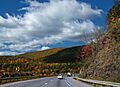
Interstate 80 in southern Luzerne County
-
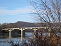
Specialist Dale J. Kridlo Bridge (U.S. Route 11)
-
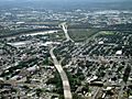
North Cross Valley Expressway (PA 309)
-
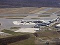
Wilkes-Barre/Scranton International Airport
See also
 In Spanish: Condado de Luzerne para niños
