Wyoming Valley facts for kids
Quick facts for kids
Wyoming Valley
|
|
|---|---|
| Scranton–Wilkes-Barre, PA MSA | |
| Country | |
| State | |
| Largest city | Scranton |
| Other cities | - Wilkes-Barre - Hazleton - Carbondale - Pittston City (Greater Pittston) - Nanticoke |
| Area | |
| • Total | 1,776 sq mi (4,600 km2) |
| Highest elevation | 2,460 ft (750 m) |
| Lowest elevation | 400 ft (100 m) |
| Population | |
| • Total | 567,559 |
| • Rank | 100th in the U.S. |
| Time zone | UTC−5 (EST) |
| • Summer (DST) | UTC−4 (EDT) |
The Wyoming Valley is a historic area in Northeastern Pennsylvania. It is famous for its many anthracite coal-mines. These mines helped power the American Industrial Revolution. The region is also known as the Scranton–Wilkes-Barre metropolitan area. This name comes from its two main cities, Scranton and Wilkes-Barre.
As of 2020, about 567,559 people live here. This makes it the fifth-largest metropolitan area in Pennsylvania. Other large areas include the Delaware Valley and Greater Pittsburgh.
Contents
What is the Wyoming Valley?
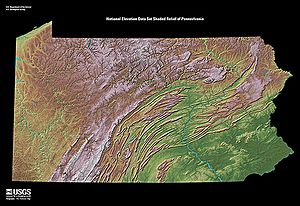
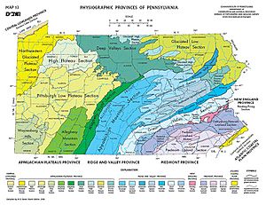
The Wyoming Valley is a special part of Pennsylvania's geology. It is called the Anthracite Valley. This valley is shaped like a crescent, or a half-moon. It is part of the ridge-and-valley or folded Appalachians. The Susquehanna River flows through the southern part of the valley.
Why is Coal Important Here?
The valley is well-known for its large deposits of anthracite coal. This type of coal has been mined a lot here. However, deep mining has become less common. This is because strip mining is often cheaper. Some local mines also closed due to coal fires. A major event in 1959, the Knox Mine disaster, caused a mine roof under the Susquehanna River to collapse. This led to many mining companies leaving the area.
Cities in the Valley
Greater Pittston is located in the middle of the valley. Scranton is the biggest city in the metropolitan area. It has about 77,114 people. Scranton's population grew after 2015. Wilkes-Barre is the second largest city. Hazleton is the third largest. From higher spots to the east, you can often see the Pocono Mountains.
History of the Wyoming Valley
Early Beginnings of the Valley
The name Wyoming comes from a Native American word. It means "at the big river flat." In 1635, the Scahentoarrhonon people lived in the valley. Later, by 1744, Lenape, Mohican, and Shawnee people lived there. They had moved from eastern areas.
From the 1740s to the 1760s, Moravian missionaries worked with Native Americans here. They hoped to create a settlement for Christian Indians. But the French and Indian War caused these settlers to leave.
Land Disputes and Conflicts
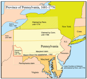
The land in the Wyoming Valley was claimed by two different colonies: Pennsylvania and Connecticut. King Charles II gave the land to Connecticut in 1662. Then, in 1681, he gave it to William Penn, who started Pennsylvania. This led to fights called the Pennamite–Yankee War.
In 1769, settlers from Connecticut started Wilkes-Barre. People from Pennsylvania, called Pennamites, tried to force them out. They tried in 1769, 1770, and again in 1775.
The Revolutionary War and the Valley
During the American Revolutionary War, a major battle happened here. The Battle of Wyoming took place on July 3, 1778. More than 300 American Revolutionaries died. They were fighting against Loyalists and their Iroquois allies.
A Scottish poet, Thomas Campbell, wrote a poem about it in 1809. It was called Gertrude of Wyoming. The poem helped make the valley famous. Later, the state of Wyoming was named after this valley.
How Luzerne County Was Formed
The land disputes between Connecticut and Pennsylvania were settled in the 1780s. The Wyoming Valley became part of Pennsylvania. People from Connecticut still wanted to create a new state in Northeastern Pennsylvania.
To solve this, the Pennsylvania government created Luzerne County. This stopped the idea of a new state. Luzerne County was formed on September 25, 1786. It was named after Chevalier de la Luzerne, a French soldier and diplomat. At first, Luzerne County was very large. But between 1810 and 1878, it was divided into smaller counties. These include Bradford, Lackawanna, Susquehanna, and Wyoming counties.
The Scranton–Wilkes-Barre Metropolitan Area
The Scranton–Wilkes-Barre–Hazleton, PA Metropolitan Statistical Area is also known as the Wyoming Valley. It includes Lackawanna, Luzerne, and Wyoming counties. In 2015, about 558,166 people lived in this area.
Neighboring Counties
The counties next to the Wyoming Valley include:
- Monroe County (Southeast)
- Susquehanna County (Northeast)
- Wayne County (East)
- Columbia County (West)
- Bradford County (Northwest)
- Carbon County (South)
- Sullivan County (West)
- Schuylkill County (Southwest)
Population Changes Over Time
When metropolitan areas were first defined in 1950, Scranton and Wilkes-Barre were separate. Lackawanna County was the Scranton area. Luzerne County was the Wilkes-Barre–Hazleton area. They merged after the 1970 census. It was renamed the Scranton–Wilkes-Barre metropolitan area after 1980.
After the 2000 census, some changes happened. Columbia County was no longer part of the metropolitan area. Hazleton was also removed as a primary city. Scranton is now the largest city in the entire metropolitan area. Its population is almost double that of Wilkes-Barre.
| County | 2022 Estimate | 2020 Census | Change | Area | Density |
|---|---|---|---|---|---|
| Luzerne County | 326,369 | 325,594 | +0.24% | 890.33 sq mi (2,305.9 km2) | 367/sq mi (142/km2) |
| Lackawanna County | 215,615 | 215,896 | −0.13% | 459.08 sq mi (1,189.0 km2) | 470/sq mi (180/km2) |
| Wyoming County | 26,014 | 26,069 | −0.21% | 397.32 sq mi (1,029.1 km2) | 65/sq mi (25/km2) |
| Total MSA Population | 567,998 | 567,559 | +0.08% | 1,746.73 sq mi (4,524.0 km2) | 325/sq mi (125/km2) |
The Physical Valley vs. The Metro Area
It's important to know that the physical Wyoming Valley is different from the metropolitan statistical area. The physical valley is shaped like a canoe. It is about 25 miles (40 km) long. It stretches from Susquehanna and Wayne counties in the north. It goes down to Columbia County in the south.
This physical valley includes cities like Carbondale, Scranton, Pittston, Wilkes-Barre, and Nanticoke. Even though Wyoming County is part of the metropolitan area, it is not part of the physical valley itself.
Culture and Fun in the Valley
Scranton is the main cultural hub of the Wyoming Valley. It is the largest city in the area.
Sports Teams You Can Cheer For
The Wyoming Valley has several professional sports teams:
- The Scranton/Wilkes-Barre RailRiders play Minor League Baseball (Triple-A).
- The Wilkes-Barre/Scranton Penguins play American Hockey League hockey.
- The Scranton/Wilkes-Barre Steamers play in the Premier Basketball League.
There was also a minor league arena football team, the Wilkes-Barre/Scranton Pioneers, from 2001 to 2009.
Places to Visit and Explore
There are many fun places to visit in the Wyoming Valley:
- Mohegan Sun Arena at Casey Plaza in Wilkes-Barre hosts concerts and events.
- Pocono Raceway in Long Pond is a famous race track.
- PNC Field in Moosic is where the RailRiders play baseball.
- Mohegan Pennsylvania in Plains offers entertainment.
- The Toyota Pavilion in Scranton is an outdoor concert venue.
- Shopping malls include the Wyoming Valley Mall in Wilkes-Barre, the Shoppes at Montage in Moosic, the Steamtown Mall in Scranton, and the Viewmont Mall in Scranton/Dickson City, Pennsylvania.
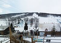
- For outdoor fun, there's the Montage Mountain Waterpark/Ski Resort in Scranton.
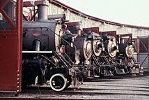
- Historic sites include Eckley Miners' Village and the Steamtown National Historic Site.
Transportation in the Valley
The main airports for this area are Wilkes-Barre/Scranton International Airport and the Wilkes-Barre Wyoming Valley Airport. These airports connect the region to other parts of the country.
See also
 In Spanish: Área metropolitana de Scranton-Wilkes-Barre para niños
 | Tommie Smith |
 | Simone Manuel |
 | Shani Davis |
 | Simone Biles |
 | Alice Coachman |


