
Susquehanna County, Pennsylvania facts for kids
Quick facts for kids
Susquehanna County
|
|
|---|---|

The Susquehanna County Courthouse in Montrose
|
|

Location within the U.S. state of Pennsylvania
|
|
 Pennsylvania's location within the U.S. |
|
| Country | |
| State | |
| Founded | October 13, 1812 |
| Named for | Susquehanna River |
| Seat | Montrose |
| Largest borough | Forest City |
| Area | |
| • Total | 832 sq mi (2,150 km2) |
| • Land | 823 sq mi (2,130 km2) |
| • Water | 8.7 sq mi (23 km2) 1.0% |
| Population
(2020)
|
|
| • Total | 38,434 |
| • Density | 46.195/sq mi (17.836/km2) |
| Time zone | UTC−5 (Eastern) |
| • Summer (DST) | UTC−4 (EDT) |
| Congressional district | 9th |
Susquehanna County is a county located in Pennsylvania, a state in the United States. In 2020, about 38,434 people lived there. The main town, or county seat, is Montrose.
The county was officially created on February 21, 1810. It was formed from a part of Luzerne County. Susquehanna County was named after the Susquehanna River. It is part of the Northeast Pennsylvania area of the state.
Contents
History of Susquehanna County
Early Settlers and Conflicts
The first European settlers started moving into this area in the mid-1700s. They came from places like Philadelphia and Connecticut. At that time, this land was part of Luzerne County.
More and more people from Connecticut arrived. This led to disagreements because Connecticut also claimed this land. Connecticut's original land grant said it owned land all the way to the Pacific Ocean. This claim overlapped with Pennsylvania's land.
Soon, fighting broke out between settlers from both states. This conflict was called the Pennamite–Yankee Wars. It lasted from 1769 to 1799. In the end, Connecticut gave up its claim to the area.
How the County Was Formed
In 1810, Susquehanna County was officially created. It was made from a part of Luzerne County. Two years later, in 1812, Montrose became the county seat.
Coal Mining and Growth
After the Civil War, people started mining coal in the county. This led to new railways and roads being built. More people moved to the area because of the jobs. At one point, nearly 50,000 people lived in the county.
Coal mining became very important for the local economy. It brought a time of great success and growth to Susquehanna County.
The Great Depression and Decline
When the Great Depression happened, the coal industry faced big problems. Many mines closed, and the economy struggled. During World War II, coal mining picked up for a short time. But soon after, the county's economy declined again.
Many jobs were lost, and the population started to shrink. Railways were even taken apart.
Geography of Susquehanna County

Susquehanna County covers about 832 square miles. Most of this area, about 823 square miles, is land. The rest, about 8.7 square miles, is water.
The county has many mountains, especially in the east. In the west, the mountains are smaller and more like hills. The highest point is North Knob, near Union Dale. Most people live in the long, narrow valleys. These valleys have good land for farming.
The county has a climate with warm summers. In Montrose, the average temperature in January is about 21.2°F. In July, it's about 67.7°F.
Neighboring Counties
Susquehanna County shares borders with several other counties:
- Broome County, New York (north)
- Wayne County (east)
- Lackawanna County (south)
- Wyoming County (south)
- Bradford County (west)
- Tioga County, New York (northwest)
Population and People

In 2000, there were 42,238 people living in Susquehanna County. There were 16,529 households. Most people in the county were White (98.54%). Other groups included Black or African American, Native American, and Asian. About 0.67% of the population was Hispanic or Latino.
Many people in the county have roots from different European countries. The largest groups were English (26%), German (16.1%), Irish (15.1%), Italian (8.6%), and Polish (7.7%).
The population was spread out by age. About 25.5% were under 18 years old. The median age was 40 years. This means half the people were younger than 40 and half were older.
2020 Census Information
In 2020, the population of Susquehanna County was 38,434.
| Race | Number | Percent |
|---|---|---|
| White (not Hispanic) | 35,799 | 93.14% |
| Black or African American (not Hispanic) | 138 | 0.36% |
| Native American (not Hispanic) | 59 | 0.15% |
| Asian (not Hispanic) | 135 | 0.35% |
| Pacific Islander (not Hispanic) | 0 | 0% |
| Other/Mixed (not Hispanic) | 1,456 | 3.8% |
| Hispanic or Latino | 847 | 2.2% |
Economy and Jobs
The economy in Susquehanna County mainly relies on a few key areas. These include retail stores, healthcare, public schools, small businesses, and government jobs.
Main Employers
Here are some of the biggest employers in the county:
- Montrose Area School District
- Barnes-Kasson County Hospital
- Pennsylvania State Government
- Endless Mountains Health Systems
- Susquehanna County government
- Mountain View School District
- Elk Lake School District
- Gassearch Drilling Services Corp
- Blue Ridge School District
- Cabot Oil & Gas Corporation
Natural Gas Industry
Since 2008, drilling for natural gas has grown in the county. Some people believe this has helped the economy. The unemployment rate has changed over time. In January 2018, it was 5.7 percent.
Even with natural gas drilling, the county's population has gone down. Between 2010 and 2016, the population decreased by about 5.8 percent.
Tourism in the County
Susquehanna County is becoming a popular place for tourists. People enjoy its natural beauty, skiing, and charming small villages.
Education

Kids in Susquehanna County attend various schools.
Public School Districts
Here are the public school districts in the county:
- Blue Ridge School District (New Milford)
- Elk Lake School District (Dimock)
- Forest City Regional School District (Forest City)
- Montrose Area School District (Montrose)
- Mountain View School District (Kingsley)
- Susquehanna Community School District
Public Libraries
The county has several public libraries where kids can read and learn:
- Susquehanna County Historical Society & Free Library Association
- Pratt Memorial Library
- Forest City Library
- Hallstead Public Library
- Hallstead-Great Bend Library
- Susquehanna Free Library
Vocational Schools
- Susquehanna County Career and Technology Center (Dimock Township) helps students learn job skills.
Private Schools
- Faith Mountain Christian Academy (New Milford) is a private school option.
Transportation
Major Roads
 I-81
I-81 US 11
US 11 PA 29
PA 29 PA 92
PA 92 PA 106
 PA 167
 PA 171
 PA 247
 PA 267
 PA 367
 PA 370
 PA 371
 PA 374
 PA 407
 PA 492
 PA 547
 PA 706
 PA 848
 PA 858
Train Services
The last passenger trains stopped running through Susquehanna County in 1970. Now, only freight trains use the railway lines.
Airports
Susquehanna County has a few small airstrips for fun. For bigger flights, the closest main airports are in Binghamton, New York and Scranton, Pennsylvania.
Recreation and Fun
There is one Pennsylvania state park in Susquehanna County:
- Salt Springs State Park is about 7 miles north of Montrose. It's a great place to explore nature.
There are also nine historic places in the county listed on the National Register of Historic Places.
Towns and Communities

In Pennsylvania, there are different types of towns. Susquehanna County has boroughs and townships.
Boroughs
These are smaller, often more populated areas:
- Forest City
- Friendsville
- Great Bend
- Hallstead
- Hop Bottom
- Lanesboro
- Little Meadows
- Montrose (This is the county seat!)
- New Milford
- Oakland
- Susquehanna Depot
- Thompson
- Union Dale
Townships
These are usually larger, more rural areas:
- Apolacon
- Ararat
- Auburn
- Bridgewater
- Brooklyn
- Choconut
- Clifford
- Dimock
- Forest Lake
- Franklin
- Gibson
- Great Bend
- Harford
- Harmony
- Herrick
- Jackson
- Jessup
- Lathrop
- Lenox
- Liberty
- Middletown
- New Milford
- Oakland
- Rush
- Silver Lake
- Springville
- Thompson
Images for kids
-
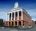
The Susquehanna County Courthouse in Montrose
-
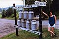
Milk Can Corners in Hallstead
-
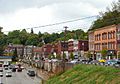
Susquehanna Depot Main Street
-
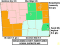
Map of Susquehanna County, Pennsylvania, school districts
-
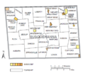
Political map of Susquehanna County, Pennsylvania, with townships and boroughs labeled. Townships are colored white and boroughs are colored various shades of orange.
See also
 In Spanish: Condado de Susquehanna para niños
