
Salt Springs State Park facts for kids
Quick facts for kids Salt Springs State Park |
|
|---|---|
|
IUCN Category III (Natural Monument)
|
|
.jpg)
Fall Brook passes through Salt Springs State Park
|
|

Salt Springs State Park
Location in Pennsylvania
|
|
| Location | Franklin, Susquehanna, Pennsylvania, United States |
| Area | 405 acres (164 ha) |
| Elevation | 1,211 ft (369 m) |
| Established | 1973 |
| Governing body | Pennsylvania Department of Conservation and Natural Resources |
| Website | Salt Springs State Park |
Salt Springs State Park is a special place in Pennsylvania. It is a state park located in Franklin Township, Susquehanna County.
This park is famous for its huge hemlock trees. Some of these trees are over 500 years old! They are among the biggest trees in all of Pennsylvania. The park also has a deep gorge with three amazing waterfalls on Fall Brook.
Salt Springs State Park is about 7 miles (11 km) north of Montrose. You can find it just off Pennsylvania Route 29. What makes this park unique is that a non-profit group, the Friends of Salt Springs Park, helps manage it. The state owns 405 acres (164 ha) of land here. The Friends group owns another 437 acres (177 ha). This means a total of 842 acres (341 ha) of land is protected for everyone to enjoy.
Contents
Park History: From Forests to Farms
Ancient Hemlock Trees
The first settlers arrived in the Salt Springs area around the 1790s. They found a huge, untouched forest. This forest was full of giant eastern hemlock trees. The settlers wanted to clear the land for farming. Many trees were simply burned. Others were used to build log cabins.
Later, people started stripping the bark from hemlock trees. This bark was used in tanneries to make leather. Other trees were cut down for the lumber industry. Soon, Sawmills appeared on Silver Creek and other streams. But not all the old hemlocks were cut down. The trees in Fall Brook Gorge were saved. This area became a popular spot for fun as early as the 1800s.
The Salty Springs
Salt Springs State Park gets its name from the salty springs found there. These springs are on the south side of Fall Brook. Long ago, Native Americans used these springs to get salt. Early settlers also took salt from the spring water.
Many people tried to make money by getting salt from the springs. But most of them failed. It was just too hard to get enough salt to make a profit.
Searching for Oil
Later, people came looking for Oil in the Salt Springs area. This was during a big oil boom in Pennsylvania. Oil had been found near Titusville, far to the west. In 1902, the North Penn Oil and Gas Company drilled a test well. They quickly gave up, sealed the well, and left.
However, methane gas escaped from this well. The Wheaton family, who owned a nearby dairy farm, used this gas. For many years, it provided light for their home and fuel for their stove!
From Farm to State Park
The Wheaton family owned the land that is now Salt Springs State Park from 1840 until 1973. They ran a dairy farm there. They also invited visitors to enjoy the tall hemlock trees and Fall Brook Gorge. In 1973, they sold their land to the state of Pennsylvania.
The state bought the land, but didn't have enough money to take care of the old buildings or develop the park. So, in 1994, a non-profit group called "Friends of Salt Springs Park" was formed. They wanted to protect the park. When the historic buildings on the old Wheaton Farm were going to be torn down, this group stepped in. They worked to save the farm buildings and help develop the park.
In 1995, the Friends signed a 10-year agreement with Susquehanna County. They became the caretakers of the park. This agreement has been renewed several times since then.

Today, the Wheaton farm buildings are used by the park. The Wheaton House, made of timber from eastern hemlock, holds the Friends' offices. Another farmhouse is rented out, which helps support the Friends' work. A carriage barn, also made of hemlock timbers, has hand-cut beams and a foundation of native stone without mortar. This barn and the dairy barn are used for programs, history displays, and events.
Fun Activities at Salt Springs Park
Salt Springs State Park offers many ways to have fun outdoors.
Hunting and Fishing
Most of the park is open for hunting. However, a 30-acre nature preserve in the Fall Brook Gorge area is off-limits. Hunters must follow the rules of the Pennsylvania Game Commission. You might see ruffed grouse, squirrels, turkey, and white-tailed deer here. Hunting groundhogs is not allowed.
Fall Brook and Silver Creek are great for trout fishing. The Pennsylvania Fish and Boat Commission adds trout to these streams before the spring trout season.
Camping and Picnics
The park has 12 spots for rustic tent camping. There are also 3 cottages you can rent for a night or a week.
You'll find a small picnic area between Silver Creek and Fall Brook. It has tables and grills. There's also a large timber frame pavilion near Salt Spring. This pavilion used to be a barn! In 2014, another pavilion was built in a nearby meadow.
Hiking and Skiing Trails
Salt Springs State Park has over 15 miles of trails. These trails are perfect for hiking and cross-country skiing. They lead you through old forests, along the gorge, and through fields and woods.
- Fall Brook Trail is a 1-mile difficult trail. It is marked with red blazes. The trail starts across the creek from Wheaton House. It follows Fall Brook up a steep hill and passes three waterfalls. This trail ends at Bunny Trail.
- Silver Creek Trail is an easy 1.5-mile trail. It is marked with red blazes. It starts behind the dairy barn. The trail follows Silver Creek through a hemlock forest. It ends with a steep climb near Meadow Trail.
- Meadow Trail is an easy 0.8-mile loop trail. It is marked with yellow blazes. You can reach it from the Silver Creek Trail or Buckley Road. This trail goes through meadows and past old stone foundations.
- Hemlock Trail is a moderate 0.4-mile trail. It is not marked. This trail goes through an old-growth forest of eastern hemlock trees. It leads to the Salt Springs gorge. You can reach a gorge observation platform from Hemlock Trail.

- Woodland Trail is an easy 0.25-mile loop trail. It is marked with blue blazes. It branches off Hemlock Trail through the old forest. You might need to climb over a 300-year-old fallen hemlock tree on this trail.
- Hardwood Trail is a moderate 0.5-mile trail. It is marked with yellow blazes. The trail starts at the picnic area and ends at Woodland Trail. It goes through a forest of mixed hardwood trees.
- Upland Trail is a moderate 0.5-mile loop trail. It is marked with red blazes. It climbs a hillside covered with mixed hardwood trees.
- Bunny Trail is a moderate 1.5-mile loop trail. It is marked with orange blazes. It starts and ends at a parking lot off Buckley Road. The trail goes through a mixed forest and past several springs.
- Cliff Trail is a moderate 1.5-mile trail. It is marked with blue blazes. It follows Bunny Trail in some places. Cliff Trail passes by ferns, a pond, and large boulders.
- Connector Trail is an easy 1.7-mile trail. It is marked with white blazes. It connects Wetland Trail and Fall Brook Trail. The trail goes through a ravine and crosses the Wetland Trail bridge.
- Wetland Trail is an easy 0.6-mile trail. It is marked with blue blazes. It runs along the south bank of Fall Brook and goes through a wetland area.
- Summit Trail is a moderate 1-mile trail. It is marked with red blazes. It climbs a gentle hill on the Friends of Salt Springs State Park property. The top is fairly flat with widely spaced trees.
- Overlook Trail is the shortest trail at 0.2 miles. It was designed to be easy for everyone to use. It connects the falls overlook with a parking lot and Fall Brook Trail.
- Friends Trail is a moderate 1.9-mile trail. It is marked with white blazes. You can get to it from Hardwood Trail or the parking lot on Buckley Road. It goes through meadows and woodlands, along an old logging trail, and connects to Summit Trail.
- Gorge Trail is a moderate 0.5-mile trail. It is marked with blue blazes. It runs along the west edge of the Fall Brook gorge. After a short climb, it levels out and winds along the top of the gorge.
- Border Trail is a moderate to difficult 2.1-mile trail. It is marked with blue blazes. It starts behind the dairy barn, following Silver Creek Trail. It continues straight when Silver Creek branches off. It then follows the western park border and eventually returns to Silver Creek Trail.
Nearby Parks to Explore
If you like Salt Springs State Park, here are some other state parks within 30 miles (48 km):
- Chenango Valley State Park in New York
- Lackawanna State Park in Lackawanna County
- Oquaga Creek State Park in New York
Images for kids
-
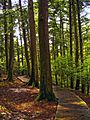
A stand of hemlocks along Hemlock Trail at Salt Springs State Park

