
Union Dale, Pennsylvania facts for kids
Quick facts for kids
Union Dale, Pennsylvania
|
|
|---|---|
|
Borough
|
|
.jpg)
Looking south along Main Street
|
|

Location of Union Dale in Susquehanna County, Pennsylvania.
|
|

Union Dale, Pennsylvania
Location in Pennsylvania

Union Dale, Pennsylvania
Location in the United States
|
|
| Country | United States |
| State | Pennsylvania |
| County | Susquehanna |
| Incorporated | 1885 |
| Area | |
| • Total | 2.47 sq mi (6.39 km2) |
| • Land | 2.41 sq mi (6.23 km2) |
| • Water | 0.06 sq mi (0.16 km2) |
| Population
(2020)
|
|
| • Total | 222 |
| • Estimate
(2021)
|
223 |
| • Density | 99.33/sq mi (38.35/km2) |
| Time zone | UTC-5 (Eastern (EST)) |
| • Summer (DST) | UTC-4 (EDT) |
| ZIP code |
18470
|
| Area code(s) | 570 |
| FIPS code | 42-78456 |
Union Dale is a small town, called a borough, located in Susquehanna County, Pennsylvania, in the United States. It became an official borough in 1885. In 2020, about 222 people lived in Union Dale.
Contents
Exploring the Geography of Union Dale
Union Dale is located at coordinates 41.715974 degrees North and -75.486995 degrees West.
Land and Water Areas
According to the United States Census Bureau, Union Dale covers a total area of about 2.5 square miles (6.5 square kilometers). Most of this area, about 2.4 square miles (6.2 square kilometers), is land. The remaining 0.1 square miles (0.26 square kilometers) is water.
Nearby Mountains and High Points
Just outside Union Dale, you can find the North Knob of Elk Mountain. This is the highest point in Eastern Pennsylvania. It is also the highest point in the Allegheny Plateau, which is a large area of high land.
Understanding Union Dale's Population
| Historical population | |||
|---|---|---|---|
| Census | Pop. | %± | |
| 1880 | 146 | — | |
| 1890 | 360 | 146.6% | |
| 1900 | 351 | −2.5% | |
| 1910 | 355 | 1.1% | |
| 1920 | 370 | 4.2% | |
| 1930 | 331 | −10.5% | |
| 1940 | 348 | 5.1% | |
| 1950 | 350 | 0.6% | |
| 1960 | 287 | −18.0% | |
| 1970 | 279 | −2.8% | |
| 1980 | 321 | 15.1% | |
| 1990 | 303 | −5.6% | |
| 2000 | 368 | 21.5% | |
| 2010 | 267 | −27.4% | |
| 2020 | 222 | −16.9% | |
| 2021 (est.) | 223 | −16.5% | |
| Sources: | |||
The census helps us understand the people living in Union Dale. In 2010, there were 267 people living in the borough. These people lived in 130 different homes.
Diversity in Union Dale
Most of the people in Union Dale are White, making up about 98.5% of the population. About 1.1% are African American. A small number, 0.4%, are from two or more racial backgrounds. About 1.5% of the population identifies as Hispanic or Latino.
Age Groups in the Community
The population of Union Dale is spread across different age groups:
- About 16.5% of the people are under 18 years old.
- About 64% are between 18 and 64 years old.
- About 19.5% are 65 years old or older.
The average age in Union Dale is 48 years.
Education in Union Dale
Students living in Union Dale attend schools within the Forest City Regional School District. This school district provides public education for students from preschool all the way through 12th grade.
Images for kids
-
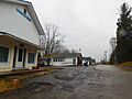
Looking south along Main Street
-
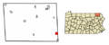
Location of Union Dale in Susquehanna County, Pennsylvania.
See also
 In Spanish: Union Dale (Pensilvania) para niños
