Lanesboro, Pennsylvania facts for kids
Quick facts for kids
Lanesboro, Pennsylvania
|
|
|---|---|
|
Borough
|
|

|
|

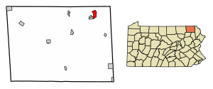
Location of Lanesboro in Susquehanna County, Pennsylvania.
|
|
| Country | United States |
| State | Pennsylvania |
| County | Susquehanna |
| Established | 1888 |
| Area | |
| • Total | 2.68 sq mi (6.95 km2) |
| • Land | 2.62 sq mi (6.78 km2) |
| • Water | 0.06 sq mi (0.17 km2) |
| Population
(2020)
|
|
| • Total | 508 |
| • Density | 194.12/sq mi (74.94/km2) |
| Time zone | UTC-5 (EST) |
| • Summer (DST) | UTC-4 (EDT) |
| Zip Code |
18827, 18847
|
| Area code(s) | 570 |
| FIPS code | 42-41336 |
Lanesboro is a small town, called a borough, located in Susquehanna County, Pennsylvania, in the United States. In 2020, about 485 people lived there.
Contents
Lanesboro's History
Lanesboro got its name from an early settler named Martin Lane. He first called the area Lanesville. Later, his son, Jesse Lane, changed the name to Lanesboro. The town officially became a borough in 1889.
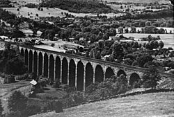
A very important bridge in the area is the Starrucca Viaduct. This historic bridge was added to the National Register of Historic Places in 1975. This means it is recognized as a special place worth protecting.
Geography of Lanesboro
Lanesboro is located at these coordinates: 41 degrees, 57 minutes, 48 seconds North and 75 degrees, 34 minutes, 55 seconds West. This helps pinpoint its exact spot on a map.
The United States Census Bureau says that Lanesboro covers a total area of about 2.66 square miles (6.9 square kilometers). Most of this area, about 2.6 square miles (6.7 square kilometers), is land. A small part, about 0.06 square miles (0.17 square kilometers), is water.
Population and People
| Historical population | |||
|---|---|---|---|
| Census | Pop. | %± | |
| 1880 | 348 | — | |
| 1890 | 876 | 151.7% | |
| 1900 | 821 | −6.3% | |
| 1910 | 771 | −6.1% | |
| 1920 | 805 | 4.4% | |
| 1930 | 731 | −9.2% | |
| 1940 | 637 | −12.9% | |
| 1950 | 591 | −7.2% | |
| 1960 | 502 | −15.1% | |
| 1970 | 550 | 9.6% | |
| 1980 | 465 | −15.5% | |
| 1990 | 659 | 41.7% | |
| 2000 | 588 | −10.8% | |
| 2010 | 506 | −13.9% | |
| 2020 | 485 | −4.2% | |
| 2021 (est.) | 482 | −4.7% | |
| Sources: | |||
Lanesboro's Population in 2010
According to the 2010 census, 506 people lived in Lanesboro. There were 217 households, which are groups of people living together. Out of these, 122 were families.
The population density was about 194.6 people per square mile (75 people per square kilometer). There were 243 housing units, like houses or apartments.
Most of the people in Lanesboro were White (96.4%). A small number were Black or African American (0.4%), Native American (0.4%), or Asian (0.4%). About 2.4% of the people were from two or more races.
Households and Families
In 26.7% of the households, there were children under 18 years old. About 37.8% of households were married couples living together. In 13.4% of households, a female head of household lived without a husband. About 43.8% of households were not families.
Almost 37% of households had only one person living there. About 25% of households had one person who was 65 years old or older. The average household had 2.33 people. The average family had 3.02 people.
Age and Income
The people in Lanesboro had different ages. About 25.7% were under 18 years old. Most people, 53.7%, were between 18 and 64 years old. About 20.6% of the population was 65 years old or older. The average age in Lanesboro was 42.5 years.
The median household income was $29,083. This means half of the households earned more than this amount, and half earned less. The median family income was $35,179.
For individuals, men earned about $31,141 on average, while women earned about $28,409. The average income per person in the borough was $16,319. About 25.2% of families and 19.6% of all people lived below the poverty line. This included 16.5% of those under 18 and 40.9% of those 65 or older.
See also
 In Spanish: Lanesboro (Pensilvania) para niños
 | Dorothy Vaughan |
 | Charles Henry Turner |
 | Hildrus Poindexter |
 | Henry Cecil McBay |


