Hop Bottom, Pennsylvania facts for kids
Quick facts for kids
Hop Bottom, Pennsylvania
|
|
|---|---|
|
Borough
|
|
 |
|

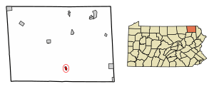
Location of Hop Bottom in Susquehanna County, Pennsylvania.
|
|
| Country | United States |
| State | Pennsylvania |
| County | Susquehanna |
| Settled | 1799 |
| Incorporated | 1881 |
| Area | |
| • Total | 0.61 sq mi (1.58 km2) |
| • Land | 0.61 sq mi (1.57 km2) |
| • Water | 0.00 sq mi (0.01 km2) |
| Population
(2020)
|
|
| • Total | 311 |
| • Density | 513.20/sq mi (198.30/km2) |
| Time zone | UTC-5 (Eastern (EST)) |
| • Summer (DST) | UTC-4 (EDT) |
| ZIP code |
18824
|
| Area code(s) | 570 and 272 |
| FIPS code | 42-35624 |
Hop Bottom is a small town, also called a borough, located in Susquehanna County, Pennsylvania, United States. In 2020, about 310 people lived there. The town gets its name from a plant called a hop. These plants have flowers that are used to make beer.
History of Hop Bottom
Hop Bottom was once known by a different name: "Foster." The current name, Hop Bottom, comes from a nearby stream called Hop Bottom Creek.
Long ago, Native Americans lived in this area. The only clear, open fields they could find were close to the bottom of this creek. These fields were covered with many hop vines. This is how the name "Hop Bottom" came to be. The town was settled in 1799 and officially became a borough in 1881.
Geography and Location
Hop Bottom is located in Pennsylvania. Its exact spot on a map is at 41°42′18″N 75°45′56″W / 41.70500°N 75.76556°W.
The borough covers a total area of about 0.6 square miles (1.58 square kilometers). Almost all of this area is land.
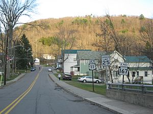
Hop Bottom is an important meeting point for roads. It is where U.S. Route 11 and Pennsylvania Route 167 connect. It is also just seven miles west of Interstate 81, a major highway.
People of Hop Bottom (Demographics)
| Historical population | |||
|---|---|---|---|
| Census | Pop. | %± | |
| 1890 | 299 | — | |
| 1900 | 326 | 9.0% | |
| 1910 | 364 | 11.7% | |
| 1920 | 349 | −4.1% | |
| 1930 | 354 | 1.4% | |
| 1940 | 375 | 5.9% | |
| 1950 | 375 | 0.0% | |
| 1960 | 381 | 1.6% | |
| 1970 | 430 | 12.9% | |
| 1980 | 405 | −5.8% | |
| 1990 | 345 | −14.8% | |
| 2000 | 333 | −3.5% | |
| 2010 | 337 | 1.2% | |
| 2020 | 310 | −8.0% | |
| 2021 (est.) | 309 | −8.3% | |
| Sources: | |||
Based on the census from 2010, there were 337 people living in Hop Bottom. These people lived in 138 different homes, and 88 of these were families.
Most people living in the borough were White (98.5%). A small number (1.5%) were from two or more racial backgrounds. About 1.2% of the population identified as Hispanic or Latino.
In terms of age, about 22.6% of the people were under 18 years old. Most of the population, 63.8%, were adults between 18 and 64 years old. About 13.6% of the people were 65 years old or older. The average age in Hop Bottom was 39 years.
See also
 In Spanish: Hop Bottom (Pensilvania) para niños
 | Aurelia Browder |
 | Nannie Helen Burroughs |
 | Michelle Alexander |


