
West Nanticoke, Pennsylvania facts for kids
Quick facts for kids
West Nanticoke, Pennsylvania
|
|
|---|---|

Along northbound US 11
|
|

West Nanticoke, Pennsylvania
Location in Pennsylvania

West Nanticoke, Pennsylvania
Location in the United States
|
|
| Country | United States |
| State | Pennsylvania |
| County | Luzerne |
| Township | Plymouth |
| Area | |
| • Total | 0.7 sq mi (1.8 km2) |
| • Land | 0.6 sq mi (1.5 km2) |
| • Water | 0.1 sq mi (0.3 km2) |
| Population
(2010)
|
|
| • Total | 749 |
| • Density | 1,078/sq mi (416/km2) |
| Time zone | UTC-5 (Eastern (EST)) |
| • Summer (DST) | UTC-4 (EDT) |
| Area code(s) | 570 |
West Nanticoke is a small community in Pennsylvania, United States. It is located in Luzerne County, specifically within Plymouth Township. This area is known as a "census-designated place" (CDP). This means it's a special area defined by the government for counting people. West Nanticoke sits on one side of the Susquehanna River. Right across the river is the city of Nanticoke. In 2010, about 749 people lived in West Nanticoke.
Contents
Exploring West Nanticoke's Location
West Nanticoke is found at specific map coordinates: 41°13′18″N 76°0′54″W / 41.22167°N 76.01500°W. It is located along U.S. Route 11. This main road runs along the north bank of the Susquehanna River.
Connecting to Nanticoke
West Nanticoke is directly across the river from the city of Nanticoke. A bridge called the Lower Broadway Street Bridge connects these two places. This makes it easy for people to travel between them.
Major Roads and Directions
Pennsylvania Route 29 meets U.S. Route 11 right in the middle of West Nanticoke.
- If you go north on Route 29, you will reach towns like Silkworth and Pikes Creek.
- Just east of West Nanticoke, Route 29 changes into the South Cross Valley Expressway. This expressway crosses the Susquehanna River. It then leads to Interstate 81, which is south of Wilkes-Barre.
- U.S. Route 11 goes northeast towards Plymouth and Kingston.
- If you head southwest on U.S. Route 11, you will find Shickshinny and Berwick.
Size of West Nanticoke
The United States Census Bureau has measured the total area of West Nanticoke. It covers about 1.8 square kilometers (or 0.7 square miles). Most of this area is land, which is about 1.5 square kilometers (0.6 square miles). The rest, about 0.3 square kilometers (0.1 square miles), is water. This means about 17.2% of West Nanticoke is covered by water.
Images for kids
-
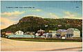
Tilsburys Knob, West Nanticoke
-
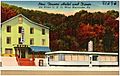
A hotel and diner along U.S. 11 in West Nanticoke
-
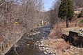
Harveys Creek looking upstream in West Nanticoke
-
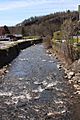
Harveys Creek looking downstream in West Nanticoke
.jpg)
.jpg)


See also
 In Spanish: West Nanticoke para niños
