
Harveys Creek facts for kids
Quick facts for kids Harveys Creek |
|
|---|---|

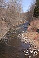
Harveys Creek looking upstream in West Nanticoke
|
|
| Other name(s) | Harvey Creek, Harvey's Creek |
| Physical characteristics | |
| Main source | Harveys Lake in Harveys Lake, Luzerne County, Pennsylvania 1,226 ft (374 m) |
| River mouth | Susquehanna River in Plymouth Township, Luzerne County, Pennsylvania 518 ft (158 m) 41°13′11″N 76°00′59″W / 41.2197°N 76.0165°W |
| Basin features | |
| Progression | Susquehanna River → Chesapeake Bay |
| Basin size | 46.3 sq mi (120 km2) |
| Tributaries |
|
Harveys Creek is a cool stream in Luzerne County, Pennsylvania. It's also sometimes called Harvey Creek or Harvey's Creek. This creek is about 14.5 miles (23.3 km) long. It flows through several towns like Harveys Lake and Plymouth Township.
The area of land that drains into Harveys Creek is 46.3 square miles (120 km2). This area is called its watershed. The creek has four smaller streams that flow into it. These are Bear Hollow Creek, Paint Spring Run, Pikes Creek, and East Fork Harveys Creek.
Harveys Creek is a special place for fish. The upper part is known as a High-Quality Coldwater Fishery. This means it's a great home for fish that like cold, clean water. It's also a Migratory Fishery, which means fish travel through it. The creek starts at Harveys Lake, which is the biggest natural lake in Pennsylvania.
People have used Harveys Creek for water since the early 1900s. Many bridges have been built over it since the 1920s. There's even a dam on it called the Bryant Pond Dam. You can also go canoeing on some parts of the creek. The land around the creek has interesting rocks like sandstone and shale.
Contents
Journey of Harveys Creek


Harveys Creek starts its journey in Harveys Lake. It flows southwest and quickly enters Lake Township. A little way downstream, it meets Bear Hollow Creek. Then, it turns south for a few miles.
Along this path, it also picks up Paint Spring Run. The creek then enters Lehman Township. Here, it turns southeast and flows under Pennsylvania Route 118. After about a mile, it turns south again.
Eventually, the creek reaches Jackson Township. It crosses Pennsylvania Route 29 and is joined by Pikes Creek. Then, it turns southeast and flows through a valley. It follows Pennsylvania Route 29 for several miles.
Finally, Harveys Creek enters Plymouth Township. It soon turns sharply southwest. A few miles later, it reaches West Nanticoke. Here, it crosses U.S. Route 11 and flows into the Susquehanna River.
Smaller Streams Joining Harveys Creek
Harveys Creek has four main smaller streams, called tributaries, that flow into it. They are Bear Hollow Creek, Paint Spring Run, Pikes Creek, and East Fork Harveys Creek.
- Bear Hollow Creek joins Harveys Creek near its beginning.
- Paint Spring Run flows into Harveys Creek about 11.42 miles (18.38 km) before it reaches the Susquehanna River. The land area that drains into Paint Spring Run is about 2.35 square miles (6.1 km2).
- Pikes Creek joins Harveys Creek about 5.60 miles (9.01 km) before its end. Its drainage area is larger, at 11.6 square miles (30 km2).
- East Fork Harveys Creek meets Harveys Creek about 3.12 miles (5.02 km) before it ends. This stream's drainage area is 7.31 square miles (18.9 km2).
Water Quality and Weather

Sometimes, Harveys Creek and its tributary, East Fork Harveys Creek, have higher levels of nutrients. These nutrients can come from things like fertilizers. While East Fork Harveys Creek has some water quality issues, Harveys Creek itself is generally in good shape.
In the 1970s, scientists measured different things about the creek's water.
- The water's ability to conduct electricity (specific conductance) was between 70 and 90 micro-siemens.
- The pH level, which tells you if water is acidic or basic, was usually between 6.5 and 7.8. This is a good range for aquatic life.
- The amount of dissolved oxygen was high, between 9.7 and 12.0 milligrams per liter. Fish need dissolved oxygen to breathe.
- The water's hardness was between 27 and 37 milligrams per liter.
Scientists also measured other substances in the water.
- Carbon dioxide levels were low, from 0.3 to 8.7 milligrams per liter.
- Levels of ammonia, nitrates, and nitrites (different forms of nitrogen) were also measured.
- Phosphorus levels ranged from 0.040 to 0.160 milligrams per liter.
- Other minerals like sulfates, chlorides, magnesium, and calcium were also present.
- The amount of iron was between 120 and 740 micrograms per liter.
The amount of water flowing in Harveys Creek can change a lot. For example, at the border of Lake Township and Lehman Township, there's a 10% chance that the water flow (called "peak annual discharge") could reach 1133 cubic feet per second in a year. This means a lot of water moving very fast!
The average rainfall in the Harveys Creek area is about 35 to 45 inches (89 to 114 cm) per year. The creek's water stays pretty cool, even in the summer. In the 1970s, winter temperatures were around 3.0 to 3.5 °C (37.4 to 38.3 °F). In spring and summer, they went up to 15.0 to 26.0 °C (59.0 to 78.8 °F).
Land Around the Creek

The land around Harveys Creek changes as you go along its path. Near where it joins the Susquehanna River, the elevation is about 518 feet (158 m) above sea level. Where the creek starts, at Harveys Lake, the elevation is much higher, about 1,226 feet (374 m) above sea level.
In its upper parts, the creek drops about 34.3 feet (10.5 m) for every mile it flows. In its lower parts, it drops even faster, about 97.2 feet (29.6 m) per mile. Harveys Creek is located in the Wyoming Valley region.
Much of the lower part of Harveys Creek flows through a deep, forested gorge. The areas closer to its source have swamps and glacial lakes. The tall cliffs of Tilbury Knob are also found near the creek's mouth. As mentioned, the creek begins at Harveys Lake, which is the biggest natural lake in Pennsylvania.
The land in the Harveys Creek watershed is quite "rough and hilly." The creek's path is winding, and it flows over rock formations made of sandstone and shale. People have described the creek as having "rushing waters," especially when it's flowing fast.
Harveys Creek Watershed

The watershed of Harveys Creek covers an area of 46.3 square miles (120 km2). A watershed is all the land where water drains into a particular river or stream. Harveys Creek is part of the larger Susquehanna River drainage basin. Its watershed is in the northwestern part of Luzerne County.
Harveys Creek is one of the main causes of flooding in Lake Township. However, these floods usually don't cause much damage because Lake Township doesn't have many buildings or developed areas.
The watershed also includes Harveys Lake, a large natural lake with a surface area of 658.6 acres. Pennsylvania Route 29 follows Harveys Creek for several miles.
There's a dam on Harveys Creek called Bryants Pond Dam. It's made of rock and earth, about 425 feet (130 m) long and 19 feet (5.8 m) high.
Harveys Creek and its tributary Pikes Creek are important sources of water supply for many towns. The Pennsylvania American Water Company uses water from these creeks to supply drinking water to about 67,500 people in 15 different communities, including Wilkes-Barre and Nanticoke. They are allowed to take up to 16 million gallons of water from the creeks each day.
History of Harveys Creek

The name "Harveys Creek" was officially recognized by the United States Board on Geographic Names in 1950. It was added to a national information system for geographic names in 1979.
Long ago, a very important Native American path called the Great Warrior Path crossed Harveys Creek near its mouth. This path connected Sunbury to Athens. In December 1775, a battle known as Plunkett's Battle happened very close to the creek along the Susquehanna River. This was a part of historical conflicts in the area.
The first schoolhouse in the lower part of Plymouth Township was built near Harveys Creek in 1834. The first mill in Lehman Township was built on the creek in 1837. In 1849, Johnathan Williams built a small mill on the creek. In 1869, a sad mining event happened at the Avondale Mine, just east of Harveys Creek.
In the early 1900s, several communities were located in the Harveys Creek watershed, such as Alderson and West Nanticoke. The main jobs in the area at that time were agriculture and working at summer resorts. As early as the 1890s, a water company used gravity to pump water from the creek. In the early 1900s, Harveys Creek and Pikes Creek supplied water to towns like Nanticoke and Plymouth.
In 2001, the Pennsylvania Fish and Boat Commission made a rule about Harveys Creek. They banned alcoholic beverages within 25 feet (7.6 m) of an 8.5-mile stretch of the creek. This rule helps keep the area safe and enjoyable for everyone.
Bridges Over Harveys Creek
Many bridges have been built over Harveys Creek over the years.
- A steel bridge was built in 1924, carrying T-486/East Poplar Street. It's 53.2 feet (16.2 m) long.
- In 1927, a two-span concrete bridge carrying Pennsylvania Route 29 was built in Jackson Township. It's 78.1 feet (23.8 m) long.
- Another concrete bridge for Pennsylvania Route 118 was built in 1935 in Lehman Township. It's 56.1 feet (17.1 m) long.
- A steel bridge carrying State Route 1016 was built in Lehman Township in 1952. It's 69.9 feet (21.3 m) long.
More modern bridges include:
- A four-span steel bridge for State Route 1048/Meeker Road was built in 1977 in Lehman Township. It's 29.9 feet (9.1 m) long.
- In the 1990s, several prestressed box beam bridges were built. One in 1992 for T-497/Pavlick Road (39.0 feet (11.9 m) long). Another in 1993 for T-499/Zbick Road (also 39.0 feet (11.9 m) long). And one more in 1997 for State Route 1059/Fedor Road in Lehman Township (40.0 feet (12.2 m) long).
- The newest bridge mentioned, carrying Pennsylvania Route 29 in Plymouth Township, was built in 2005. It's a two-span prestressed box beam bridge, 84.0 feet (25.6 m) long.
Wildlife and Fish in Harveys Creek
Harveys Creek is a great place for fish! The part of the creek upstream from Pikes Creek is known as a High-Quality Coldwater Fishery. This means the water is very clean and cold, perfect for certain fish. It's also a Migratory Fishery, which means fish can travel through it. Downstream from Pikes Creek, it's still a Coldwater Fishery and a Migratory Fishery.
Wild trout naturally reproduce in a long stretch of the creek. This section is about 10.86 miles (17.48 km) long, from Meeker Outlet Road down to where the creek ends. Harveys Creek is home to both brown trout and native brook trout. The creek is also regularly stocked with fish, meaning more fish are added for anglers.
Fun Activities on Harveys Creek
You can go canoeing on about 5.4 miles (8.7 km) of Harveys Creek. But you need to pick the right time! It's best to go after a fast snowmelt or within two days of heavy rain, when the water is flowing well.
Canoeing on Harveys Creek can be a bit challenging, with difficulty ratings from 2 to 4. Edward Gertler, who wrote a book called Keystone Canoeing, says the scenery along the creek is "good to very good." He also calls it an "obscure torrent," meaning it's a powerful but perhaps less well-known stream. This creek is best for experienced paddlers.
In the late 1980s, Harveys Creek was the most popular trout stream in Luzerne County. A book from 1991 even said it was the most stocked and fished stream in the county. This shows how much people enjoy fishing there!
Images for kids
-
Harveys Creek looking upstream in West Nanticoke
