Bear Hollow Creek facts for kids
Quick facts for kids Bear Hollow Creek |
|
|---|---|

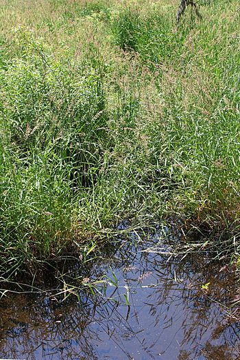
Bear Hollow Creek, mostly hidden by tall grass
|
|
| Physical characteristics | |
| Main source | pond near Bear Hollow Road in Lake Township, Luzerne County, Pennsylvania between 1,160 and 1,180 feet (350 and 360 m) |
| River mouth | Harveys Creek in Lake Township, Luzerne County, Pennsylvania 1,125 ft (343 m) 41°20′00″N 76°04′22″W / 41.3333°N 76.0729°W |
| Length | 2.0 mi (3.2 km) |
| Basin features | |
| Progression | Harveys Creek → Susquehanna River → Chesapeake Bay |
Bear Hollow Creek is a small stream in Luzerne County, Pennsylvania, in the United States. It flows into Harveys Creek. The creek is about 2 miles (3.2 km) long. It runs through Lake Township. Long ago, in the early 1900s, people used this creek for their water supply. Its valley, called Bear Hollow, was once a path for melting glaciers. Today, Bear Hollow is known for its special natural areas.
| Top - 0-9 A B C D E F G H I J K L M N O P Q R S T U V W X Y Z |
Where Bear Hollow Creek Flows
Bear Hollow Creek starts in a small pond. This pond is near Bear Hollow Road in Lake Township.
The Creek's Journey
The creek flows south-southeast for about a mile. It runs next to Bear Hollow Road. This area is a valley known as Bear Hollow.
After a mile, the creek turns southeast. It keeps flowing alongside Bear Hollow Road. The valley around it gets wider. Finally, it meets Harveys Creek. This meeting point is called its mouth.
The Land Around the Creek
The land around Bear Hollow Creek has interesting features. The creek's mouth is about 1,125 feet (343 meters) above sea level. Where the creek begins, its source, the land is a bit higher. It is between 1,160 and 1,180 feet (350 to 360 meters) above sea level.
Bear Hollow Valley
Bear Hollow is the valley where the creek flows. During the Ice Age, this valley was a deep path for glaciers. It helped drain a large ancient lake called Glacial Lake Bowman. The water from this lake flowed into Harveys Creek.
Rocks and Soil
The ground near Bear Hollow Creek has different types of soil and rock. In the upper and lower parts of the creek, you can find alluvium. This is soil left behind by flowing water.
The valley also has till. This is a mix of clay, sand, and rocks left by glaciers. You can find "Wisconsinan Till" and "Wisconsinan Bouldery Till." The hillsides of the valley have bedrock. This bedrock is made of sandstone and shale. In the middle part of the creek, there is even a small peat bog. This is a type of wetland with lots of decaying plant matter.
What Lives in Bear Hollow Creek?
Bear Hollow Creek is home to many different plants and animals. It is a special place for nature lovers.
Fish and Forests
Wild trout live and reproduce naturally in Bear Hollow Creek. They can be found from the creek's beginning all the way to its mouth.
The forests in Bear Hollow are "second-growth forests." This means they grew back after older forests were cut down. These forests have many types of trees, including:
Amazing Animals
Bear Hollow is listed on the Luzerne County Natural Areas Inventory. This means it's an important natural area. It has a very high number of different amphibian species. Amphibians are animals like frogs and salamanders.
Some amphibians you might find here include:
- Northern red salamander
- Northern dusky salamander
- Redback salamander
- Red-spotted newt
- Spotted salamander
- Spring peeper
Many types of insects also live in Bear Hollow. These include different kinds of dragonflies and damselflies, such as:
- Comet Darner
- Lance-tipped Darner
- Great Blue Skimmer
- Amber-winged Spreadwing
History of Bear Hollow Creek
Bear Hollow Creek has been recognized on maps and used by people for a long time.
Official Recognition
The creek was officially added to the Geographic Names Information System on August 1, 1989. This system keeps track of place names in the United States. Its special ID number is 1212409.
You can also find Bear Hollow Creek on county maps. These maps are published by the Pennsylvania Department of Transportation.
Past Water Use
In the early 1900s, Bear Hollow Creek was an important water supply. The Nanticoke Water Company used its water. The creek provided about one-thirtieth (1/30) of all the water the company supplied.
 | John T. Biggers |
 | Thomas Blackshear |
 | Mark Bradford |
 | Beverly Buchanan |

