Paint Spring Run facts for kids
Quick facts for kids Paint Spring Run |
|
|---|---|

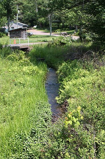
Paint Spring Run looking upstream
|
|
| Other name(s) | Painter Spring Run |
| Physical characteristics | |
| Main source | southeast of Kocher Mountain in Lake Township, Luzerne County, Pennsylvania between 1,300 and 1,320 feet (400 and 400 m) |
| River mouth | Harveys Creek in Lake Township, Luzerne County, Pennsylvania 1,102 ft (336 m) 41°19′11″N 76°04′26″W / 41.3198°N 76.0739°W |
| Length | 3.0 mi (4.8 km) |
| Basin features | |
| Progression | Harveys Creek → Susquehanna River → Chesapeake Bay |
| Basin size | 2.35 sq mi (6.1 km2) |
| Tributaries |
|
Paint Spring Run (sometimes called Painter Spring Run) is a small stream in Luzerne County, Pennsylvania, USA. It flows into Harveys Creek. This stream is about 3 miles (4.8 km) long. It runs through Lake Township. The area of land that drains into Paint Spring Run is about 2.35 square miles (6.1 km2). Wild trout live and reproduce naturally in this stream.
Contents
Where Paint Spring Run Flows
Paint Spring Run starts southeast of Kocher Mountain in Lake Township. It flows southwest for a short distance. Then, it turns south and goes through a small lake. The stream continues south-southeast for over a mile. It passes near the town of Loyalville. It also flows through another pond or small lake.
Next, the stream turns almost straight south. It passes through another small pond. Then, it gets water from an unnamed stream on its right side. After that, it turns east for a short distance. Finally, Paint Spring Run joins Harveys Creek. It meets Harveys Creek about 11.42 miles (18.38 km) upstream from where Harveys Creek ends.
Streams Joining Paint Spring Run
Paint Spring Run does not have any named smaller streams joining it. However, it does have one unnamed stream that flows into it. This unnamed stream is about 1 mile (1.6 km) long. It joins Paint Spring Run closer to where Paint Spring Run meets Harveys Creek.
Water, Land, and Rocks
The water in Paint Spring Run is considered clean. It is not listed as a polluted stream.
The land where Paint Spring Run starts is high up. It is between 1,300 and 1,320 feet (396 and 402 meters) above sea level. Where the stream ends and joins Harveys Creek, the elevation is 1,102 feet (336 meters) above sea level.
Long ago, when glaciers melted, they carved paths in the bedrock. This bedrock is made of sandstone and shale. These paths are found near the stream's source and mouth. The land around the stream also has different types of soil and rocks. These include alluvium (soil left by water), and glacial deposits. Some areas also have peat bogs and wetlands.
Paint Spring Run's Watershed
The watershed of Paint Spring Run covers an area of 2.35 square miles (6.1 square kilometers). A watershed is all the land where water drains into a specific stream or river. This stream is located entirely within the Harveys Lake area. This area is mapped by the United States Geological Survey.
There is a lake called Bryant Pond near where Paint Spring Run meets Harveys Creek. Even though Paint Spring Run is a tributary of Harveys Creek, an old report from 1921 mistakenly listed it as a tributary of Bear Hollow Creek.
History of the Name
The name Paint Spring Run was officially added to the Geographic Names Information System on August 2, 1979. This system helps keep track of names for places like rivers and mountains. Its special ID number in the system is 1183200.
Animals in Paint Spring Run
Wild trout live and naturally reproduce in Paint Spring Run. They can be found along about 2.48 miles (3.99 km) of the stream's length. This means the stream provides a good home for these fish.
 | Roy Wilkins |
 | John Lewis |
 | Linda Carol Brown |


