Luzerne, Pennsylvania facts for kids
Quick facts for kids
Luzerne, Pennsylvania
|
|
|---|---|
|
Borough
|
|

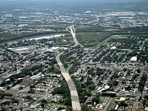
A picture of PA 309 as it travels through Luzerne and the surrounding communities. Luzerne is pictured in the foreground.
|
|

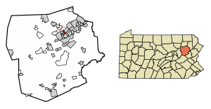
Location of Luzerne in Luzerne County, Pennsylvania
|
|
| Country | United States |
| State | Pennsylvania |
| County | Luzerne |
| Settled | 1807 |
| Incorporated | 1882 |
| Government | |
| • Type | Borough Council |
| Area | |
| • Total | 0.71 sq mi (1.83 km2) |
| • Land | 0.71 sq mi (1.83 km2) |
| • Water | 0.00 sq mi (0.00 km2) |
| Population
(2020)
|
|
| • Total | 2,711 |
| • Density | 3,834.51/sq mi (1,480.62/km2) |
| Time zone | UTC-5 (Eastern (EST)) |
| • Summer (DST) | UTC-4 (EDT) |
| Zip code |
18709
|
| Area code(s) | 570 |
| FIPS code | 42-45568 |
Luzerne is a small town, called a borough, located about 5 miles north of Wilkes Barre in Luzerne County, Pennsylvania. It's in the United States.
In 2020, about 2,703 people lived there.
History of Luzerne
People first settled in Luzerne in 1807. It officially became a borough in 1882. The town, like Luzerne County, was named after Chevalier de la Luzerne. He was a French diplomat, which means he helped his country talk with other countries.
In the early 1900s, Luzerne was a busy place. Its main jobs were in coal mining and making things in factories. The borough had coal mines, places that made metal objects (called a foundry), and factories that made drills. There were also mills for flour and animal feed, a canning factory, and a silk mill.
Geography and Location
Luzerne is located at 41°17′2″N 75°53′34″W. This is its exact spot on a map.
The United States Census Bureau says that the borough covers a total area of about 0.71 square miles (1.8 square kilometers). All of this area is land.
Population and People
| Historical population | |||
|---|---|---|---|
| Census | Pop. | %± | |
| 1890 | 2,398 | — | |
| 1900 | 3,817 | 59.2% | |
| 1910 | 5,426 | 42.2% | |
| 1920 | 5,998 | 10.5% | |
| 1930 | 6,950 | 15.9% | |
| 1940 | 7,082 | 1.9% | |
| 1950 | 6,176 | −12.8% | |
| 1960 | 5,118 | −17.1% | |
| 1970 | 4,504 | −12.0% | |
| 1980 | 3,703 | −17.8% | |
| 1990 | 3,206 | −13.4% | |
| 2000 | 2,952 | −7.9% | |
| 2010 | 2,845 | −3.6% | |
| 2020 | 2,703 | −5.0% | |
| 2021 (est.) | 2,710 | −4.7% | |
| Sources: | |||
In 2000, there were 2,952 people living in Luzerne. These people lived in 1,410 homes. About 767 of these were families.
The population density was about 4,299 people per square mile. This means a lot of people lived in a small area.
Most people living in Luzerne were White (98.92%). A small number were African American (0.34%) or Asian (0.07%). Some people were from other backgrounds.
The average age of people in Luzerne was 43 years old. About 17.6% of the population was under 18 years old. About 23.9% were 65 years or older.
Education
Students in Luzerne attend schools within the Wyoming Valley West School District.
See also
 In Spanish: Luzerne (Pensilvania) para niños
 | John T. Biggers |
 | Thomas Blackshear |
 | Mark Bradford |
 | Beverly Buchanan |


