Freeland, Pennsylvania facts for kids
Quick facts for kids
Freeland, Pennsylvania
|
|
|---|---|
|
Borough
|
|

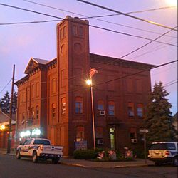
Borough building
|
|
| Nickname(s):
Freeport
|
|

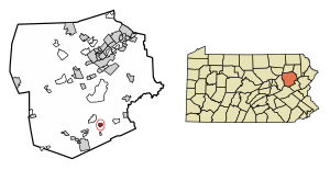
Location of Freeland in Luzerne County, Pennsylvania
|
|
| Country | United States |
| State | Pennsylvania |
| County | Luzerne |
| Settled | 1844 |
| Incorporated | 1876 |
| Government | |
| • Type | Borough Council |
| Area | |
| • Total | 0.68 sq mi (1.75 km2) |
| • Land | 0.68 sq mi (1.75 km2) |
| • Water | 0.00 sq mi (0.00 km2) |
| Elevation | 1,943 ft (592 m) |
| Population
(2020)
|
|
| • Total | 3,833 |
| • Density | 5,678.52/sq mi (2,191.78/km2) |
| Time zone | UTC-5 (Eastern (EST)) |
| • Summer (DST) | UTC-4 (EDT) |
| ZIP code |
18224
|
| Area code(s) | 570 |
| FIPS code | 42-27744 |
Freeland is a small town, called a borough, in Luzerne County, Pennsylvania, United States. It was once known by other names like Birbeckville and Freehold. Freeland is about 18 miles (29 km) south of Wilkes-Barre. It's also about 10 miles (16 km) northeast of Hazleton.
Freeland became an official borough on September 11, 1876. For many years, coal mining was the most important industry here. In 2020, about 3,833 people lived in Freeland.
| Top - 0-9 A B C D E F G H I J K L M N O P Q R S T U V W X Y Z |
History of Freeland
How Freeland Started
The founder of Freeland was Joseph Birkbeck. He was born in England in 1802. Joseph and his wife Elizabeth came to America in 1844. That same year, he bought land and built a log cabin in a small valley.
Another early settler, Nathan Howey, bought land from Birkbeck. He built a house near Birkbeck's cabin.
The Role of Coal Mining
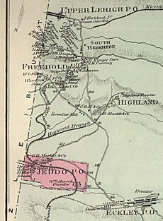
As coal mines grew in the area, more people moved in. This created a need for more homes. Joseph Birkbeck then planned out the town of South Heberton. Today, South Heberton is part of Freeland. It's mostly a group of houses along Schwabe Street.
Between 1845 and 1846, Birkbeck built a road called Buck Mountain Road. It connected South Heberton, Eckley Miners' Village, and Buck Mountain. Eckley was known for making shingles back then.
The first baby born in South Heberton was Elizabeth Birkbeck in 1845. She was the daughter of Joseph and Elizabeth Birkbeck. The first person to pass away there was William, their four-year-old son, in 1846.
The first store in South Heberton was owned by a man named Feist. The first tavern (a type of inn) was started by Nathan Howey. Before Howey's tavern, Joseph Birkbeck would host people looking for coal in his own home.
Becoming a Borough

The areas of Freehold and South Heberton joined together to form modern-day Freeland. Freeland officially became a borough on September 11, 1876. Two years later, in 1878, a wooden school building was constructed. By 1880, over 600 people lived in the community.
In 1883, the first Slovak Lutheran Church in America was founded in Freeland. The town's population grew steadily. This was because the coal mining industry was expanding. Many people from Europe moved to Freeland until the mid-1900s.
Freeland Today

The coal mining industry in Freeland ended after the 1959 Knox Mine Disaster. This disaster happened in northern Luzerne County.
Today, Freeland has many community resources. These include a YMCA program, a community park, and a branch of the Hazleton Area Public Library. There is also a newly updated Little League baseball field. Another field, Della Croce Field, is named after a former director of the Freeland YMCA. It is used for football and baseball.
Local Traditions
Many people in Freeland have Irish family backgrounds. Because of this, every year there is a St. Patrick's Day parade downtown. A dinner usually follows the parade.
Freeland also holds annual events for Memorial Day and Veterans Day. This is to honor the many soldiers, both retired and active, who live in the area.
Geography and Climate
Where Freeland is Located
Freeland is located about 18 mi (29 km) south of Wilkes-Barre. It is also about 10 mi (16 km) northeast of Hazleton. The area around Freeland is mostly farmland.
The United States Census Bureau says that Freeland covers about 0.66 square miles (1.7 km2) of land. There is no water area within the borough. Foster Township completely surrounds Freeland.
Pennsylvania Route 940 runs through Freeland. This road connects Freeland to Hazleton and White Haven. The closest airport is Hazleton Regional Airport. It is about two miles northwest of Hazleton City.
Freeland's Weather
Freeland has a "Warm Summer Continental Climate." This means it has warm summers and cold winters.
| Climate data for Freeland, Pennsylvania | |||||||||||||
|---|---|---|---|---|---|---|---|---|---|---|---|---|---|
| Month | Jan | Feb | Mar | Apr | May | Jun | Jul | Aug | Sep | Oct | Nov | Dec | Year |
| Mean daily maximum °F (°C) | 29 (−2) |
32 (0) |
39 (4) |
50 (10) |
65 (18) |
73 (23) |
78 (26) |
75 (24) |
67 (19) |
57 (14) |
41 (5) |
33 (1) |
51 (11) |
| Mean daily minimum °F (°C) | 13 (−11) |
17 (−8) |
24 (−4) |
33 (1) |
44 (7) |
53 (12) |
59 (15) |
57 (14) |
50 (10) |
39 (4) |
32 (0) |
21 (−6) |
37 (3) |
| Average precipitation inches (cm) | 3 (7.6) |
2.9 (7.4) |
3.5 (8.9) |
4.1 (10) |
4.4 (11) |
4.6 (12) |
5 (13) |
4.3 (11) |
4 (10) |
3.7 (9.4) |
4 (10) |
3.5 (8.9) |
47.1 (120) |
| Source: Weatherbase | |||||||||||||
Education in Freeland
Freeland is part of the Hazleton Area School District. Students in elementary and middle school attend Freeland Elementary/Middle School.
MMI Preparatory School is also located in Freeland. It is a college preparatory school for students in grades 6 through 12.
People of Freeland
| Historical population | |||
|---|---|---|---|
| Census | Pop. | %± | |
| 1880 | 624 | — | |
| 1890 | 1,730 | 177.2% | |
| 1900 | 5,254 | 203.7% | |
| 1910 | 6,197 | 17.9% | |
| 1920 | 6,666 | 7.6% | |
| 1930 | 7,098 | 6.5% | |
| 1940 | 6,593 | −7.1% | |
| 1950 | 5,909 | −10.4% | |
| 1960 | 5,068 | −14.2% | |
| 1970 | 4,784 | −5.6% | |
| 1980 | 4,285 | −10.4% | |
| 1990 | 3,909 | −8.8% | |
| 2000 | 3,643 | −6.8% | |
| 2010 | 3,531 | −3.1% | |
| 2020 | 3,833 | 8.6% | |
| Sources: | |||
In 2010, there were 3,531 people living in Freeland. Most residents (about 95.78%) were White. Other groups included African Americans, Native Americans, and Asian Americans. About 5.81% of the population identified as Hispanic or Latino.
Many white residents in Freeland have family roots from different European countries. In 2000, the main ancestries reported were Italian, Polish, Irish, German, and Slovak.
In 2010, about 23.22% of the population was under 18 years old. About 18.75% were 65 years or older. The average age in 2000 was 42 years old.
Notable People from Freeland
- Basil Schott – A Byzantine Catholic bishop.
- Raymond E. Schultz – The founder of Hampton Inn hotels. He was also a former CEO of Promus Hotel Corporation.
See also
 In Spanish: Freeland (Pensilvania) para niños
 | Kyle Baker |
 | Joseph Yoakum |
 | Laura Wheeler Waring |
 | Henry Ossawa Tanner |


