
Swoyersville, Pennsylvania facts for kids
Quick facts for kids
Swoyersville, Pennsylvania
|
|
|---|---|
|
Borough
|
|

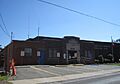
Swoyersville Borough Municipal Building
|
|

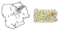
Location of Swoyersville in Luzerne County, Pennsylvania.
|
|

Swoyersville, Pennsylvania
Location in Pennsylvania

Swoyersville, Pennsylvania
Location in the United States
|
|
| Country | United States |
| State | Pennsylvania |
| County | Luzerne |
| Incorporated | 1888 |
| Government | |
| • Type | Borough Council |
| Area | |
| • Total | 2.16 sq mi (5.59 km2) |
| • Land | 2.16 sq mi (5.59 km2) |
| • Water | 0.00 sq mi (0.00 km2) |
| Elevation | 560 ft (170 m) |
| Population
(2020)
|
|
| • Total | 5,008 |
| • Estimate
(2021)
|
5,007 |
| • Density | 2,318.98/sq mi (895.35/km2) |
| Time zone | UTC−5 (Eastern (EST)) |
| • Summer (DST) | UTC−4 (EDT) |
| ZIP code |
18704
|
| Area code | 570 |
| FIPS code | 42-75832 |
Swoyersville is a small town, called a borough, located in Luzerne County, Pennsylvania, in the United States. In 2020, about 5,008 people lived there. Swoyersville is part of the Wyoming Valley West School District, which means students go to schools in that area.
Contents
History of Swoyersville
Swoyersville has an interesting past! It was first known as Swoyerville. The town officially became a borough in 1888. It was named after John Henry Swoyer, who owned a mine in the area.
How Swoyersville Got Its Name
In the 1950s, the people of Swoyerville had a special vote. They decided if they wanted to add an "s" to the town's name. The idea passed, and the town became known as Swoyersville.
Coal Mining and Floods
For many years, coal mining was the main industry in Swoyersville. This meant many people worked in the mines. However, the mines stopped producing coal in the 1950s. This happened after a big event called the Knox Mine Disaster. Even after the mines closed, some work continued at the coal processing plant on Main Street into the 1960s.
In 1972, a major flood hit the town. This was caused by Hurricane Agnes and the Susquehanna River overflowing. People worried that the old, empty mine tunnels under Swoyersville might collapse because of the water. Luckily, these collapses did not happen.
Geography of Swoyersville

Swoyersville is located at 41°17′41″N 75°52′36″W / 41.294602°N 75.876684°W. The borough covers about 5.5 square kilometers (2.16 square miles) of land. There is no water area within the borough.
Town Landscape
The southern part of Swoyersville is mostly flat. However, the northern part of the borough has hills. Most of the land in Swoyersville is developed for homes and businesses. There are also some forested areas in the northern parts.
The Coal Ash Pile
Swoyersville is home to a very large pile of coal ash. This pile is as tall as a 17-story building and is surrounded by homes. Coal ash is a leftover material from burning coal. The mayor, Christopher Concert, wants to have this pile removed. He is looking for money from the state and federal governments to help move it. Interestingly, the mayor used to go sledding on this pile when he was a child.
Population of Swoyersville
| Historical population | |||
|---|---|---|---|
| Census | Pop. | %± | |
| 1900 | 2,264 | — | |
| 1910 | 5,396 | 138.3% | |
| 1920 | 6,876 | 27.4% | |
| 1930 | 9,133 | 32.8% | |
| 1940 | 9,234 | 1.1% | |
| 1950 | 7,795 | −15.6% | |
| 1960 | 6,751 | −13.4% | |
| 1970 | 6,786 | 0.5% | |
| 1980 | 5,795 | −14.6% | |
| 1990 | 5,630 | −2.8% | |
| 2000 | 5,157 | −8.4% | |
| 2010 | 5,062 | −1.8% | |
| 2020 | 5,008 | −1.1% | |
| 2021 (est.) | 5,007 | −1.1% | |
| Sources: | |||
In 2000, there were 5,157 people living in Swoyersville. These people lived in 2,243 households. About 1,484 of these households were families.
Who Lives in Swoyersville?
The population density was about 2,386 people per square mile. Most of the people living in Swoyersville were White (99.22%). A small number of people were African American, Native American, Asian, or from other backgrounds. About 0.16% of the population was of Hispanic or Latino origin.
Households and Ages
In 2000, about 24% of households had children under 18 living with them. More than half (51.5%) of households were married couples. About 11.1% of households had a female head with no husband present.
The average household had 2.30 people. The average family had 2.88 people. The median age in Swoyersville was 44 years old. This means half the people were younger than 44, and half were older.
- 18.5% of the population was under 18 years old.
- 6.6% was between 18 and 24 years old.
- 26.7% was between 25 and 44 years old.
- 24.7% was between 45 and 64 years old.
- 23.4% was 65 years or older.
Income Information
In 2000, the median income for a household in Swoyersville was $30,434 per year. For families, the median income was $39,188 per year. The average income per person in the borough was $16,449. About 10.8% of the population lived below the poverty line. This included 19.3% of those under 18 and 6.5% of those 65 or older.
Education in Swoyersville
Swoyersville is part of the Wyoming Valley West School District. This district serves the students living in the borough.
Famous People from Swoyersville
Many notable people have come from Swoyersville, including athletes and politicians.
- Adam Comorosky – A baseball player who played for the Pittsburgh Pirates and Cincinnati Reds.
- Harry Dorish – A baseball pitcher for teams like the Boston Red Sox and Chicago White Sox.
- Jim Hettes – A professional mixed martial arts fighter in the UFC.
- Joe Holup – A basketball player for the NBA's Syracuse Nationals and Detroit Pistons.
- Lou Michaels – A former football kicker for the Baltimore Colts.
- Walt Michaels – A former head coach for the New York Jets football team.
- Dick Mulligan – A former Major League Baseball pitcher.
- John Paluck – A former football player for the Washington Redskins.
- Packy Rogers – A baseball infielder for the Brooklyn Dodgers.
- Steve Shemo – A former Major League Baseball second baseman.
- Fred Shupnik – A former member of the Pennsylvania House of Representatives.
- Chuck Sieminski – A former American football player.
Images for kids
-
Swoyersville Borough Municipal Building
-
Location of Swoyersville in Luzerne County, Pennsylvania.
-
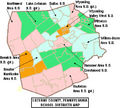
A map of Luzerne County school districts. Swoyersville is part of Wyoming Valley West School District (seen in orange).
See also
 In Spanish: Swoyersville para niños
