
Sugarloaf Township, Luzerne County, Pennsylvania facts for kids
Quick facts for kids
Sugarloaf Township,
Luzerne County, Pennsylvania |
|
|---|---|
|
Township
|
|

"Highacres" (now Penn State Hazleton), built in 1924
|
|

Map of Luzerne County highlighting Sugarloaf Township
|
|

Map of Pennsylvania highlighting Luzerne County
|
|
| Country | United States |
| State | Pennsylvania |
| County | Luzerne |
| Area | |
| • Total | 22.47 sq mi (58.20 km2) |
| • Land | 22.45 sq mi (58.16 km2) |
| • Water | 0.02 sq mi (0.04 km2) |
| Population
(2020)
|
|
| • Total | 3,879 |
| • Estimate
(2021)
|
3,885 |
| • Density | 180.64/sq mi (69.74/km2) |
| Time zone | UTC-5 (Eastern (EST)) |
| • Summer (DST) | UTC-4 (EDT) |
| ZIP code |
18249
|
| Area code(s) | 570 and 272 |
| FIPS code | 42-079-75064 |
Sugarloaf Township, often called Sugarloaf, is a community located in Luzerne County, Pennsylvania, USA. In 2020, about 3,879 people lived there.
Contents
A Look Back: Sugarloaf's History
.jpg)
The area that is now Sugarloaf Township was once part of Newport Township. Early settlers mostly stayed near the Susquehanna River. The Conyngham Valley, where Sugarloaf is, remained mostly unexplored for a long time.
The Conyngham Valley became known after the Sugarloaf massacre in 1780. During this event, about ten American soldiers were killed. They were attacked by a group of Native Americans and some Loyalists. After the fight, groups came to bury the soldiers. Stories from these visitors made more settlers want to move to the valley.
It is thought that George Easterday was the first white settler in what is now Sugarloaf Township. Other settlers followed, many from Northampton County. In 1792, Nescopeck Township was created from part of Newport Township.
Sugarloaf Township was officially formed in 1809. It was named after Sugarloaf Mountain, a cone-shaped mountain in the valley. Sugarloaf Township used to be much larger. It included areas that are now Black Creek, Hazle, and Butler Townships.
The first sawmill in the area was built by John Cawley in 1810. It was located on Nescopeck Creek. Later, Benjamin and George Koening built the first gristmills between 1815 and 1820. A steam mill was built by Stephen Yost in 1865.
Exploring Sugarloaf's Geography
Sugarloaf Township covers about 22.47 square miles (58.2 square kilometers). Most of this area is land, with only a tiny bit of water. The township's water drains into the Susquehanna River. Sugarloaf is located in Luzerne County's Conyngham Valley.
Nescopeck Mountain forms the northern border of the township. Buck Mountain and Butler Mountains are on its southern side. A large part of the township is made up of farmland.
Local Communities and Roads
Sugarloaf Township has several small communities. These include Black Ridge, Council Crest, Sybertsville, and Tomhicken.
Major roads help people travel through the township. PA 93 runs through Sugarloaf. It connects with I-80 in the northern part of the township. I-81 also crosses the southeastern corner of Sugarloaf. Here, it connects with PA 93 in Black Ridge.
Education in Sugarloaf
Sugarloaf Township is part of the Hazleton Area School District. This district runs public schools for the area. One of these is the Valley Elementary-Middle School, located right in Sugarloaf Township. Penn State Hazleton is also found in the southeastern part of the township, near Black Ridge.
Neighboring Towns and Townships
Sugarloaf Township shares its borders with several other communities:
- West Hazleton (to the south)
- Hazle Township (to the south)
- Black Creek Township (to the west)
- Nescopeck Township (to the northwest)
- Hollenback Township (to the north)
- Butler Township (to the east)
It's interesting to note that Sugarloaf Township completely surrounds Conyngham Borough.
Population and People
| Historical population | |||
|---|---|---|---|
| Census | Pop. | %± | |
| 2000 | 3,652 | — | |
| 2010 | 4,211 | 15.3% | |
| 2020 | 3,879 | −7.9% | |
| 2021 (est.) | 3,885 | −7.7% | |
| U.S. Decennial Census | |||
In 2000, about 3,652 people lived in Sugarloaf Township. There were 1,222 households, which are groups of people living together. Most of these households (944) were families.
The population density was about 166.6 people per square mile. This means that, on average, 166.6 people lived in each square mile of the township.
Most of the people in the township were White (98.03%). There were also smaller percentages of African American, Native American, and Asian residents. About 0.71% of the population was Hispanic or Latino.
In 2000, about 30.4% of households had children under 18 living with them. Most households (67.3%) were married couples. The average household had 2.60 people, and the average family had 2.98 people.
The median age in the township was 38 years old. This means half the people were younger than 38, and half were older.
Images for kids
-
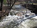
Little Nescopeck Creek in Sugarloaf
-
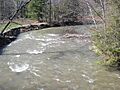
Little Nescopeck Creek in Sugarloaf
-
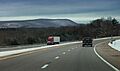
I-80 near Sugarloaf
-
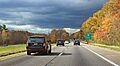
I-80 near Sugarloaf


.jpg)
_(15578015405).jpg)
See also
 In Spanish: Municipio de Sugarloaf (condado de Luzerne) para niños
