
Little Nescopeck Creek facts for kids
Quick facts for kids Little Nescopeck Creek |
|
|---|---|

Little Nescopeck Creek looking upstream near its mouth
|
|

Satellite map of Little Nescopeck Creek. The red dot is the stream's source and blue dot is its mouth.
|
|
| Physical characteristics | |
| Main source | Butler Township |
| River mouth | Sybertsville 900 ft (270 m) |
| Length | 8.5 mi (13.7 km) |
| Basin features | |
| Basin size | 14 sq mi (36 km2) |
Little Nescopeck Creek is a stream in Luzerne County, Pennsylvania, United States. It flows into a larger stream called Nescopeck Creek. The creek is about 8.5 miles (13.7 km) long. It flows through Butler Township, Sugarloaf Township, and Conyngham. The land area that drains into the creek, called its watershed, is about 14 square miles (36 km2).
The creek's water is often acidic. This is partly because of polluted water from the Jeddo Tunnel. The main type of rock in the area is called the Mauch Chunk Formation. Other rocks, like the Pottsville Formation, are also found. Different types of soil, such as Arnot Series and Basher Series, are in the watershed.
The Jeddo Tunnel is the main source of acid mine drainage in the Little Nescopeck Creek area. Big roads like Interstate 80 and Pennsylvania Routes 93 and 309 cross the creek's watershed. There are also wetlands, which are areas of land covered by water. People have lived in this watershed since about 8000 B.C.E. However, European settlers arrived much later, in the 1700s. A historical event called the Sugarloaf Massacre happened near the creek in 1780. Today, people can enjoy activities like swimming and boating. There are also golf courses, public parks, and walking trails in the area.
The Little Nescopeck Creek watershed is known as a good place for coldwater fish and migrating fish. Fish live near the start of the creek. But, there is almost no aquatic life downstream from the Jeddo Tunnel because of pollution. Many types of amphibians (like frogs) and reptiles (like snakes) live here. Dozens of insect and macroinvertebrate species also call this area home. Common mammals include white-tailed deer and cottontail rabbits. Plants like conifer and hardwood trees, herbs, and grasses grow in the watershed.
Contents
Where the Creek Flows

Little Nescopeck Creek starts in a valley near Prospect Rock in Butler Township. It flows west-southwest for a short distance. Then, it turns west-northwest as its valley gets wider. The creek goes under Pennsylvania Route 309. After more than a mile, it turns west-southwest again for several miles. It crosses Interstate 81 and enters Sugarloaf Township. Here, it flows along the base of Butler Mountain.
In Sugarloaf Township, the creek turns northwest. It flows through Conyngham before turning north. A short distance downstream, it joins Nescopeck Creek. Little Nescopeck Creek meets Nescopeck Creek about 19.26 miles (31 km) upstream from its mouth.
Water Conditions
Before the Jeddo Tunnel was built, Little Nescopeck Creek was about 10 feet (3 meters) wide. Now, it is much wider, around 30 to 40 feet (9 to 12 meters) wide. This is ten times wider than it was in the early 1700s. Other things, like water from sewage treatment plants and more storm runoff, have also made the creek wider.
There are plans to clean up the pollution from the Jeddo Tunnel. These plans include reducing the water flowing out of the tunnel. They also involve building more wetlands to help filter the water. Upstream of the Jeddo Tunnel, the creek's water flow is about 2.18 cubic feet per second. Downstream of the tunnel, it jumps to 60.02 cubic feet per second. The water's ability to conduct electricity (called specific conductance) also increases a lot after the tunnel.
The average rainfall in the Little Nescopeck Creek watershed was about 49 inches (124 cm) per year between 1932 and 1998. Near where Little Nescopeck Creek joins Nescopeck Creek, there are exciting white-water rapids. Some parts are rated as Class III or even Class IV, meaning they are quite challenging. Little Nescopeck Creek is also one of the main causes of flooding in Conyngham.
Water Quality Details
Between 1996 and 1998, the average pH of Little Nescopeck Creek was 4.6. This means the water was quite acidic. For comparison, pure water has a pH of 7, and lower numbers mean more acidity.
The water also contained different amounts of metals. For example, the amount of manganese was much higher downstream from the Jeddo Tunnel. Upstream, it was around 108 micrograms per liter. Downstream, it was 3320 micrograms per liter. Similarly, aluminum and iron levels were much higher after the tunnel. The amount of zinc also increased a lot after the tunnel.
There are also some non-metallic pollutants in the creek. These include ammonia, phosphorus, and nitrite. However, the Jeddo Tunnel does not add much of these specific pollutants.
Land and Rocks
The land around Little Nescopeck Creek is part of the Ridge-and-Valley Appalachians. This area has many long, parallel ridges and valleys. The elevation near the creek's mouth is about 860 feet (262 meters) above sea level. The creek's source is higher, between 1420 and 1440 feet (433 to 439 meters) above sea level.
Most of Little Nescopeck Creek flows over a rock layer called the Mauch Chunk Formation. This rock formed during the Mississippian period. It is made of shale, conglomerate, and coarse gray sandstone. This formation is found at the bottom of the creek valley and on Nescopeck Mountain. Another rock layer, the Pottsville Formation, is also in the watershed. It has coarse sandstone, gray quartz conglomerate, and shale. There is no coal in the Little Nescopeck Creek watershed, and the area has never been mined.
There are several types of soil in the watershed. The Arnot Series soil is shallow and drains well. It can be flat or steep. Alluvial land is found along flood plains and contains gravel and stones. The Basher Series soil is reddish-brown and sticky near Sybertsville. The creek's valley is steep and narrow. Nescopeck Mountain is to the north, and Buck Mountain is to the south. The elevation in the watershed ranges from 850 to 1800 feet (259 to 549 meters). There is very little limestone near the creek, which helps explain why the water is so acidic.
Several floodplains exist along the creek. The largest one is where the creek turns north. Another is not far from where the creek begins.
Creek's Surroundings
The watershed of Little Nescopeck Creek covers about 14 square miles (36 km2). The creek's mouth is in the Sybertsville area. The watershed includes Sugarloaf Township, Butler Township, Conyngham, and a tiny part of Hazle Township. The towns of Drums and Kis-Lyn are also in this area. To the south, the Little Nescopeck Creek watershed borders the Black Creek watershed. To the north, it borders the main part of Nescopeck Creek.
The Little Nescopeck Creek watershed is affected by pollution from the Jeddo Tunnel. This is the only source of acid mine drainage here. The pollution from the Jeddo Tunnel also impacts Nescopeck Creek, the Susquehanna River, and even the Chesapeake Bay. Most of the watershed is farmland and suburbs. However, there are also woodlands and riparian buffers, which are natural areas along the creek. Major highways like Interstate 80, Pennsylvania Route 93, and Pennsylvania Route 309 are in the watershed.
Many types of wetlands are found in the Little Nescopeck Creek watershed. Some are small, scattered areas along the creek. The largest wetland area is a forested wetland, about 1 mile (1.6 km) long and 0.1 mile (0.16 km) wide. Different types of wetlands, including those with shrubs and trees, are found in various parts of the watershed.
History of the Area
Native Americans lived near Little Nescopeck Creek as early as 8000 B.C. Some of the first people to settle here were the Lenni Lenape tribe. European settlers began arriving in the mid-1700s. The building of the Susquehanna and Lehigh Turnpike also helped more people move to the area.
A sad event called the Sugarloaf Massacre happened near the creek on September 11, 1780. In the early 1800s, people built mills along the creek. For example, Redmond Conyngham built a sawmill in 1809 and a gristmill in 1814. A carding mill was built in 1810, and a woolen mill in 1835. The creek also flooded during Hurricane Agnes in 1972.
Many historical sites in the watershed are related to the coal mining industry. The name "Nescopeck" comes from a Lenni Lenape word meaning "deep black river."
In 1995, a $50,000 grant was given to help improve the water quality of Little Nescopeck Creek. Since the early 2000s, the amount of traffic in the watershed has grown a lot. The Environmental Protection Agency has set up several sites along the creek to monitor its health.
Wildlife and Plants
The Little Nescopeck Creek area is a special place for fish that like cold water and for fish that travel (migrate). However, downstream from the Jeddo Tunnel, there is almost no aquatic life due to pollution. Even though there are plans to bring fish back, it would be very expensive right now. Near the creek's start, you can find sunfish, brook trout, brown trout, and bass. The brook trout and brown trout are native to this area. In 1998, 56 fish of eight different types were found upstream of the Jeddo Tunnel. The most common were creek chub and white sucker.
The watershed is home to 14 types of amphibians, and ten of them breed there. There are also eight types of reptiles, including two turtles and six snakes. Only the two turtle species breed in the watershed. More than 50 types of birds also live here.
The most common large game animal is the white-tailed deer. Cottontail rabbits are also common, especially near farms. Beavers, raccoons, and muskrats are the most common fur-bearing animals.
Many small creatures, called macroinvertebrates, live in the creek area. These include different kinds of flies, caddisflies, mayflies, stone flies, alder flies, and beetles. There are also 30 types of butterflies, with seven breeding in the watershed. Seven types of dragonflies and damselflies are also found, and three of them breed here.
Common plants include conifer and hardwood trees, herbs, legumes, and grasses. The plants here are typical for the Ridge-and-Valley region. Many deciduous trees, like different kinds of oak, cherry, maple, walnut, hickory, birch, and dogwood, grow in the watershed. Coniferous trees like pine and spruce are also present. There are also many types of legumes, grasses, weeds, bushes, and perennials. Many of these plants grow right along the creek in what's called the riparian zone. Aquatic plants like bulrush, pondweed, duckweed, waterweed, and algae are also found in the creek. The forests near the creek's source are mostly oak and hickory trees.
The natural area along the creek, called the riparian zone, has been saved thanks to local conservation efforts. This zone can be very narrow, sometimes even zero feet wide. But it can also be very wide, up to 500 feet (152 meters) in some places. Where Little Nescopeck Creek meets Nescopeck Creek, the riparian zone is 100 feet (30 meters) wide or more.
There are five special plant and animal species in the Little Nescopeck Creek watershed that need protection. One of these is the mountain starwort, which is critically endangered in Pennsylvania.
Fun Activities
There are not many chances for swimming or boating directly in Little Nescopeck Creek. However, there are several golf courses, public parks, and rail-trails in the watershed. The golf courses include Sugarloaf Golf Course, Sand Springs Golf Course, Edgewood in the Pines Golf Course, and the private Valley Country Club.
Three main recreational spots are in the watershed. These are the Butler Recreation Complex in the eastern part, and Whispering Willow Park and the Historic Brainard Church in the western part.
In 1998, there were plans to turn old railroad tracks in the watershed into walking and biking trails. Many trails already exist, some dating back to Native American times. There are also several scenic outlooks. People sometimes go kayaking on the creek in the spring. A 24-acre area of fields and woodlands, known as the Bishop Tract, runs along a part of Little Nescopeck Creek.
Images for kids
-
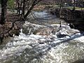
Little Nescopeck Creek looking upstream near its mouth
-
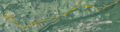
Satellite map of Little Nescopeck Creek. The red dot is the stream's source and blue dot is its mouth.
