Nescopeck Mountain facts for kids
Quick facts for kids Nescopeck Mountain |
|
|---|---|
| Nescopec Mountain Niskëpèk (Unami) |
|
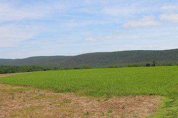
Nescopeck Mountain in Luzerne County, Pennsylvania
|
|
| Highest point | |
| Elevation | 1,594 ft (486 m) |
| Prominence | up to 850 or 900 feet (260 or 270 m) |
| Geography | |
| Parent range | chain of mountains from Moosic to the Susquehanna River |
| Topo map | Shumans, Nuremberg, Berwick, Sybertsville, Freeland, and White Haven |
| Geology | |
| Mountain type | Ridge |
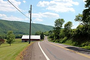
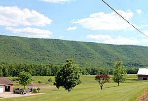
Nescopeck Mountain is a long, narrow mountain ridge in Columbia County and Luzerne County, Pennsylvania. It is also known as Nescopec Mountain. This ridge stands about 1,594 feet (486 m) above sea level.
Nescopeck Mountain is covered in thick forests. It has different types of trees and special wet areas called vernal pools. The ridge is very long and mostly unbroken. It has two natural openings, called water gaps. These gaps were carved by Catawissa Creek and Nescopeck Creek. The Nescopeck Creek gap was once used for an important road built in 1805. This road connected the Wyoming Valley to Philadelphia. Today, PA 93 follows part of this old route.
The rocks that make up the ridge include several types, like the Pocono Formation. Long ago, during the last ice age, glaciers moved over the mountain. Native Americans lived near Nescopeck Mountain a long time ago. Europeans first visited the area around 1755. The name "Nescopeck" probably means "dirty waters" or "black waters." Parts of two Pennsylvania State Game Lands and one state park are located on the mountain. The ridge stretches across many towns in both Columbia and Luzerne Counties.
Contents
Exploring Nescopeck Mountain's Location
Nescopeck Mountain reaches 1,594 feet (486 m) above sea level. This makes it the highest ridge in Columbia County. The mountain is found in towns like Beaver Township, Mifflin Township, and Main Township in Columbia County. It also extends into several towns in Luzerne County, including Nescopeck Township. The ridge reaches as far east as Nescopeck State Park.
People have described Nescopeck Mountain as "regular and almost unbroken." It is also called "beautiful and regular in its formation." The ridge stretches for almost 20 miles (32 km). It goes from near the Susquehanna River almost to the Lehigh River. The northern side of the ridge is much steeper and higher. The mountain is too rocky for farming, with many large boulders.
Nescopeck Mountain is part of a long chain of forested mountains. This chain goes from Moosic Mountain to the Susquehanna River. It is seen as an extension of Catawissa Mountain. The ridge is similar in height to other mountains near the Wyoming Valley. Nescopeck Mountain rises about 850 feet (260 m) to 900 feet (270 m) higher than the land around it in some spots. However, it is only about 400 to 500 feet (120 to 150 m) high near its western end at Mainville.
Interstate 80 crosses through the water gap that Nescopeck Creek carved in Nescopeck Mountain. The Susquehanna River Lowlands are close to the ridge. You can also find many small kettle holes, which are bowl-shaped hollows, at the base of the mountain.
Streams and Valleys Around the Ridge
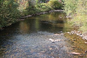
Nescopeck Creek flows near Nescopeck Mountain. Another important stream, Black Creek, joins Nescopeck Creek at the base of the ridge. For part of its length, the mountain is north of Nescopeck Creek.
There is a valley called the Nescopeck Valley. This valley lies between Nescopeck Mountain and Buck Mountain. Nescopeck Creek flows through this valley. The valley is about 20 miles (32 km) long and 5 miles (8.0 km) wide. Some streams on the ridge flow into the Lehigh River watershed.
A stream named Scotch Run flows through a valley. Nescopeck Mountain forms the northern edge of this valley.
Nescopeck Mountain forms a water gap with Catawissa Mountain. Catawissa Creek cuts through this gap. There is also another water gap carved by Nescopeck Creek through Nescopeck Mountain. Both of these water gaps are quite narrow. The mountain helps divide the land where water flows into the Susquehanna River from where it flows into the Lehigh River. For some distance, the ridge runs parallel to the Susquehanna River, about 2.5 to 3 miles (4.0 to 4.8 km) away.
The Geology of Nescopeck Mountain
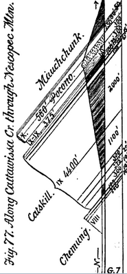
Nescopeck Mountain is mostly made of hard, tilted conglomerate rocks. These rocks belong to the Pocono Formation. There are three main rock formations on Nescopeck Mountain. These include the Trimmers Rock Formation, the Spechty Kopf Formation, and the Onondaga Formation. All three of these formations are angled in bands. The Spechty Kopf Formation is found at the very top of the ridge. The Mauch Chunk Formation is also on the ridge. The very top of the mountain is made of hard Pocono Formation rock.
There are areas with coal basins to the south of Nescopeck Mountain.
During an ice age, huge sheets of ice called glaciers pushed against Nescopeck Mountain. They eventually moved over it, carrying gravel from the Susquehanna River. The ridge was near the southern edge of where the most recent glaciers reached.
History and Name of the Ridge
Nescopeck Mountain was officially added to the Geographic Names Information System on August 2, 1979. It is also known as Nescopec Mountain. This other name appeared in a book from 1883. Nescopeck Mountain is likely named after a Native American village called Nescopeck. The word nescopeck comes from neskchoppeck. This word probably means "dirty waters" or "black waters."
Historically, a Native American village was located near Nescopeck Mountain. This is where the town of Nescopeck is today. In 1740, the Forks Indians arrived at the ridge after being forced from their lands. As early as 1755, two missionaries, Christian Seidel and Henry Frey, visited Native Americans and traveled down the ridge.
In 1838, a man named Mr. Butler asked for permission to build a tunnel through Nescopeck Mountain. This was for the Lehigh Coal and Navigation Company. In the late 1800s and early 1900s, a hotel called the Glen Summit Springs Hotel operated on top of Nescopeck Mountain. It was built by the Lehigh Valley Railroad Company. Many visitors came from the Wyoming Valley and the East Coast. The Lehigh Valley Railroad also used to cross over the ridge. In the late 1800s, people looked for coal on the ridge.
By the mid-1800s, the top of Nescopeck Mountain had lost most of its trees. Logging has taken place on the ridge in recent years. There are also plans to build communication towers on the mountain. Local goods are sometimes traded over Nescopeck Mountain. The mountain is mostly undeveloped, meaning it has not been built on much.
In the summer of 2014, a gypsy moth infestation started on Nescopeck Mountain. This caused hundreds of trees to lose their leaves. The Bureau of Forestry planned to spray the area in 2015 to control the moths.
Plants and Animals of Nescopeck Mountain
Nescopeck Mountain is home to undisturbed oak and mixed hardwood forests. These are also known as Appalachian Oak Forests. Some of the trees on the ridge include red oak, chestnut oak, scarlet oak, black birch, American chestnut, pitch pine, red maple, and serviceberry. Other plants found here are black huckleberry, lowbush blueberry, mountain laurel, sheep's laurel, bracken fern, wild sarsaparilla, and Virginia creeper.
A special type of ephemeral/fluctuating pool natural community is found on and near Nescopeck Mountain. It is called the Edgewood Vernal Pools. These are dozens of temporary pools created by glaciers. Many amphibian species use these pools to breed. Hardwood trees and hemlock trees grow around the southern edge of these pools. A very rare type of invertebrate (an animal without a backbone) was seen in these pools in 1990. Another group of vernal pools, called the Briggsville Vernal Pools, are located north of the ridge.
The Nescopeck Mountain Barrens are a unique dwarf-tree forest on the ridge top. This area has scrub oaks, hairgrass, pitch pines, little bluestems, and blueberries.
Fun Activities and Recreation
Part of the Pennsylvania State Game Lands Number 58 is located on Nescopeck Mountain. Also, the Pennsylvania State Game Lands Number 187 includes the Nescopeck Mountain Barrens. The ridge forms the northern edge of the 3550-acre Nescopeck State Park.
In the past, there were trails that led to the top of Nescopeck Mountain. From the top of the ridge, you can see far into the distance. The town of Bloomsburg can be seen from there.
The water gap where Catawissa Creek flows between Nescopeck Mountain and Catawissa Mountain has been called "attractive." The water gap where Nescopeck Creek flows through Nescopeck Mountain is described as "impressive."
 | Laphonza Butler |
 | Daisy Bates |
 | Elizabeth Piper Ensley |


