Catawissa Creek facts for kids
Quick facts for kids Catawissa Creek |
|
|---|---|
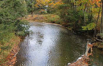
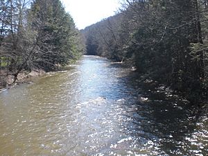
The creek near Brandonville, Pennsylvania
|
|
| Lua error in Module:Location_map at line 420: attempt to index field 'wikibase' (a nil value). | |
| Physical characteristics | |
| Main source | Southwestern Luzerne County, Pennsylvania |
| River mouth | Susquehanna River |
| Length | 41.8 mi (67.3 km) |
| Basin features | |
| Basin size | 153 sq mi (400 km2) |
| Tributaries | |
Catawissa Creek, also known as "The Cat," is a 41.8-mile-long (67.3 km) stream in east-central Pennsylvania, United States. It flows into the larger Susquehanna River. The area of land that drains into Catawissa Creek, called its watershed, covers about 153 square miles (400 km2).
The water in Catawissa Creek is quite acidic, with a pH of 4.5. This is mainly because of polluted water, called acid mine drainage, that flows into it from old, abandoned mines in the area. Catawissa Creek is smaller than the nearby Fishing Creek because it doesn't have as many large streams flowing into it.
Catawissa Creek begins in Luzerne County, not far from Hazleton. It flows generally west and then north, passing through Schuylkill County before entering Columbia County. Finally, it flows west to join the Susquehanna River at the town of Catawissa. For much of its journey, the creek flows alongside Catawissa Mountain.
The ground beneath Catawissa Creek is mostly made of sedimentary rock, like sandstone and shale. However, there is also coal in the watershed. The main types of soil found here are called Leck Kill soil and Albrights series. The steepest hills in the watershed are usually found closer to where the creek starts.
Coal mining used to be a very important industry in the Catawissa Creek watershed. While it's not a major industry anymore, its history still affects the creek today. Important streams that flow into Catawissa Creek include Little Catawissa Creek and Tomhicken Creek. Ed Wytovich, who leads the Catawissa Creek Watershed Restoration Association, once called the creek "probably the most beautiful screwed-up stream east of the Mississippi."
Contents
What's in the Water?
The water in Catawissa Creek has been affected by old coal mines. Water flowing out of tunnels from these mines carries different chemicals into the creek.
Mine Tunnels and Water Quality
Several tunnels from old mines release water into Catawissa Creek. This water often contains metals like iron, magnesium, and aluminum, as well as high levels of acidity.
- The Audenried Tunnel adds a lot of iron, magnesium, aluminum, and acidity to the creek. For example, the amount of acidity from this tunnel is much higher than what is considered safe for water.
- The Green Mountain Tunnel also adds iron, manganese, aluminum, and acidity, though generally in smaller amounts than the Audenried Tunnel.
- The Catawissa Tunnel contributes iron, manganese, aluminum, and acidity to the creek.
Acidity Levels Along the Creek
The pH level tells us how acidic or basic water is. A lower pH means more acidity.
- Near where Messers Run joins Catawissa Creek, the pH usually ranges from 4.1 to 6.2, averaging around 4.5.
- Further downstream, near Davis Run, the pH is a bit higher, averaging 4.64.
- After other streams like Rattling Run, Dark Run, and Little Catawissa Creek join, the pH can vary more, from 3.2 to 6.4, with an average of 4.96.
- After Tomhicken Creek joins, the pH is usually between 4.7 and 5.4.
Even though the water is acidic due to mine drainage, the creek's waters are mostly clear.
The Land Around the Creek
From where Catawissa Creek starts to the town of Mainville, its river valley is steep and narrow. After Mainville, the valley becomes more gently rolling.
Most of the surface rock in the Catawissa Creek watershed (93%) is made of different layers of sedimentary rock, while the rest is sandstone. South of Mainville, the valley is made of red shale. You can also find conglomerate (a rock made of pebbles), greenish-gray sandstone, olive-colored shale, and anthracite coal near the creek.
Near the creek's source, the land mainly features anthracite coal and sandstone ridges. The valleys here are narrow and steep. In other parts of the watershed, the land is mostly less steep valleys and some hills.
McCauley Mountain and Green Mountain form the sides of the Catawissa Creek valley in Beaver Township.
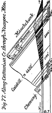
Where Catawissa Creek flows past Nescopeck Mountain in Main Township, there's a 580 feet (180 m) thick layer of rock called the Pocono Formation. Below it is another layer, 375 ft (114 m) thick, called the Pocono-Catskill Formation. Underneath that is a 100 ft (30 m) thick layer of red shale.
A greenish-gray sandstone layer near the creek has been quarried (mined for stone) for building. Below this, there's an olive-colored sandstone layer, 40 ft (12 m) to 50 feet (15 m) thick, where Spirifer fossils (ancient sea creatures) have been found. In a red shale layer, at least 100 ft (30 m) thick, fucoid fossils (ancient plant-like traces) can be seen.
Soils Along the Creek
Two main types of soil are found along Catawissa Creek:
- Leck Kill soil: This soil usually has an 8-inch (200 mm) thick layer of dark brown silt loam on top. Below that is a reddish-brown silt loam subsoil that goes down about 32 inches (810 mm). Underneath is a 6-inch (150 mm) thick layer of clay loam. The solid rock beneath this soil is red shale.
- Albrights series: This soil has a 7-inch (180 mm) thick layer of reddish-brown gravelly silt loam on top. Below this, there's a yellowish-red silty clay loam subsoil. Underneath the subsoil is a mix of gravel and silty clay loam. The solid Bedrock is usually several feet underground.
Where the Creek Flows
Starting in Luzerne County
Catawissa Creek begins in a strip mine area in southern Luzerne County and northern Schuylkill County. This is near the towns of Audenried and McAdoo, a few miles southwest of Hazleton. The creek sometimes disappears into these strip mines. It then reappears as an iron-filled pool west of Interstate 81. It flows through another strip mine before entering Schuylkill County.
Through Schuylkill County
When Catawissa Creek enters East Union Township in Schuylkill County, it flows west-southwest into a valley. It passes by hills called Round Head and Blue Head, picking up a smaller stream near Blue Head. Beyond Blue Head, the creek flows past Sheppton and then Brandonville. It picks up Rattling Run just before entering Union Township.
As the creek enters Union Township, its valley becomes very deep for a short time before getting shallower again. It picks up Dark Run in this township. The creek flows along the border of East Union Township and Union Township before entering North Union Township. In North Union Township, Catawissa Creek flows north until it reaches Zion Grove. Here, it makes a sharp turn northwest, and the valley walls become much higher and steeper. As it leaves Zion Grove, it picks up Tomhicken Creek. The creek then turns sharply west, flowing under Red Ridge. At the western edge of Red Ridge, it turns sharply north, then gently west again. It picks up Crooked Run at the edge of North Union Township, then flows into Columbia County.
Into Columbia County
Catawissa Creek enters Beaver Township in Columbia County. It immediately flows past Bunker Hill and makes several curves, passing Beaver Valley. An old Conrail railroad track starts running alongside the creek here. In southern Beaver Township, the creek flows between Buck Mountain to the east and Catawissa Mountain to the west. The creek turns sharply west near Shumans, where Pennsylvania Route 339 crosses it and Beaver Run flows in. The creek follows Catawissa Mountain closely for a bit before turning north and passing near McCauley Mountain. It winds past Dry Ridge and Full Mill Hill, where Route 339 crosses it again. The creek makes a sharp turn north and picks up Gap Run before leaving Beaver Township.
Leaving Beaver Township, the creek enters Main Township. It continues to follow Catawissa Mountain. It quickly picks up Gap Run, Fisher Run, Scotch Run, and Furnace Run. After Furnace Run, Catawissa Creek flows between Catawissa Mountain and Nescopeck Mountain through a high, narrow gorge. As the creek leaves the gorge, it passes Mainville and enters a flat area. The creek turns west-southwest, and the flat area narrows slightly. Catawissa Mountain is to the south, and lower hills are to the north. After a few miles, the creek leaves Main Township and enters Catawissa Township. In Catawissa Township, the creek flows southwest to the town of Catawissa. It follows the southern border of Catawissa, then turns north, following the western border. Pennsylvania Route 487 crosses the creek here. At the western edge of Catawissa, the creek flows into the Susquehanna River.
A Look at History
The Creek's Name and Early Settlers
The name "Catawissa" comes from an Algonquin word, "Gattawisi," which means "growing fat." Native American tribes who lived near the creek's mouth originally gave it this name. Fur traders were living along the Catawissa as early as 1728. Legend says the creek got its name because a Native American hunter killed a very fat deer nearby during the season when deer are well-fed.
European settlers arrived near Catawissa Creek before 1776. Early settlers included Alexander McCauley and Andrew Harger. Thomas Wilson, an Englishman, also lived in a cave along the creek. The first mill in Columbia County was built on Catawissa Creek in 1774. Two more mills were built on the creek in 1789 and 1799.
Modern Developments and Challenges
In 1826, a forge (a place to shape metal) was built on Catawissa Creek to make bar iron. By the late 1820s, there were plans for a railroad to run alongside Catawissa Creek, connecting Catawissa with Pottsville. The Catawissa Railroad, built in the 1830s, followed the creek for part of its path. Another railroad, the Danville, Hazleton and Wilkes-Barre Railroad, was built in 1870 and also ran alongside the creek. A paper mill was started on Catawissa Creek in Catawissa in 1811. In the late 1800s, a dam was built on the creek in Beaver Township.
In 1886, Columbia County built a bridge called the Catawissa Creek Bridge. It was destroyed by a flood in 1902 but rebuilt. Then, on March 7, 1904, ice and flooding carried the bridge about 200 feet (61 m) downstream, though it stayed in one piece. However, it was not rebuilt in that spot again.
From the mid-1800s to the early 1970s, coal was mined in the eastern part of the Catawissa Creek watershed. This mining happened mainly in the Jeansville Coal Basin and the Green Mountain Coal Basin. The Catawissa Water Company once used water from the creek. In the 1930s, five drainage tunnels were built in the watershed. These tunnels still release acid mine drainage into the creek today. Strip mining (removing coal from the surface) also happened in parts of the watershed, especially near the creek's source.
Even though deep mining of coal stopped in the 1970s, strip mining continued for some time. Today, there are still a few mining permits in the watershed, and some coal is still taken from old refuse banks (piles of mining waste).
The Pennsylvania Fish and Boat Commission has studied Catawissa Creek several times. The first study was in 1957. More studies on the water's chemistry were done in 1966 and 1976. In 1997, the commission checked the creek and its smaller streams to see if they could support fish for the first time.
People have tried to raise the pH (make it less acidic) of Catawissa Creek since the late 1900s. Between 1998 and 2000, the Catawissa Creek Restoration Association added limestone sand to the creek, but it didn't successfully raise the pH. However, in 2001, a treatment system called Oneida #1 successfully made Sugarloaf Creek, a smaller stream, less acidic. As of 2000, there were plans to change the path of Catawissa Creek to avoid the Audenried Tunnel and Green Mountain Tunnel. The Catawissa Creek Watershed Restoration Association was started in 1997 to help the creek.
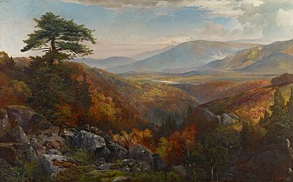
Catawissa Creek is featured in at least two paintings from 1862 by the artist Thomas Moran: On the Catawissa Creek and Valley of the Catawissa in Autumn.
The Creek's Watershed
The land area that drains into Catawissa Creek, its watershed, spans four counties: Columbia County, Schuylkill County, Luzerne County, and Carbon County. Most of the watershed is in Columbia and Schuylkill Counties, with a smaller part in Luzerne County, and only a tiny bit in Carbon County near Tresckow.
Pennsylvania Route 339 and Pennsylvania Route 924 are the main roads in the Catawissa Creek watershed. They both run alongside the creek for some distance. Interstate 81 also passes near the creek's source. Many smaller township roads crisscross the watershed. Towns like McAdoo, Kelayres, Sheppton, and Oneida are located within the watershed.
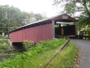
The Hollingshead Covered Bridge No. 40 crosses over Catawissa Creek.
There are five main drainage tunnels in the Catawissa Creek watershed: Audenried, Oneida #1, Oneida #3, Catawissa, and Green Mountain. The Audenried Tunnel drains the Jeansville Coal Basin on the eastern side of the watershed. Oneida #1 flows into Sugarloaf Creek, which is a tributary of Catawissa Creek. Oneida #3 flows into Tomhicken Creek, another tributary. The other two tunnels flow directly into Catawissa Creek. The Audenried Tunnel is responsible for 80% of the acid mine drainage that flows into Catawissa Creek.
Most of the land in the Catawissa Creek watershed is forested (78.4%). About 17.4% is used for agriculture, and 1% is developed land. Two percent of the land used to be coal-mining areas, including old coal mines and quarries.
Animals and Plants
While some of Catawissa Creek's smaller streams have trout, the main creek itself doesn't have any fish. This is due to the pollution from acidic mine drainage. In 1966, some woodcocks (a type of bird) were seen living along Catawissa Creek.
Rhododendrons and hemlock trees typically grow close to Catawissa Creek. Hardwood trees grow higher up in the creek's river valley. In the late 1800s, many plants that looked like fucoids (ancient algae) were found along Catawissa Creek near the border of Main and Catawissa Townships.
In the late 1950s, the Pennsylvania Fish and Boat Commission found that Catawissa Creek had good temperatures for trout. However, there was no aquatic life (animals living in the water) because of the acid mine drainage. This problem continued through the 1960s and 1970s. By 1997, large numbers of wild trout were found in some of the smaller streams that flow into Catawissa Creek. As of 2003, the part of Catawissa Creek from its source down to where Rattling Run joins it is considered a cold-water fishery (meaning it could support cold-water fish). Several other smaller streams, including Dark Run, Davis Run, Little Catawissa Creek, and Messers Run, are also considered high-quality cold water fisheries.
Aquatic macroinvertebrates (small water bugs and creatures without backbones) are not very common in Catawissa Creek as of 2003. However, some adult Allocapnia and Taeniopteryx (types of stoneflies) have been seen. Many Amphinmeura and Leuctra (other types of stoneflies) have also been observed on the creek between its source and the Audenried and Green Mountain tunnels.
Creek Branches (Tributaries)
- Spies Run and Davis Run are two streams that flow into Catawissa Creek close to where it starts. Spies Run is about one mile long and joins from the south. Davis Run is slightly longer, about 1.5 miles (2.4 km), and also joins from the south near Brandonville.
- Rattling Run is a 2.3 miles (3.7 km) stream that also flows into Catawissa Creek from the south near Brandonville.
- Dark Run and Little Catawissa Creek are the next streams downstream. Dark Run is nearly four miles long and flows in from the southwest. Little Catawissa Creek is about ten miles long and joins from the west, less than a mile downstream from Dark Run. Little Catawissa Creek starts near Centralia and passes by Ringtown.
- Tomhicken Creek is the next major stream to join Catawissa Creek downstream. It has its own smaller branches, including Raccoon Creek and Sugarloaf Creek.
- About two to three miles downstream from Tomhicken Creek, Crooked Run, Cranberry Run, and Klingerman's Run join Catawissa Creek from the south.
- Other streams like Fisher Run and Furnace Run flow down Catawissa Mountain to Catawissa Creek. Scotch Run flows into the creek from the east.
Fun on the Creek
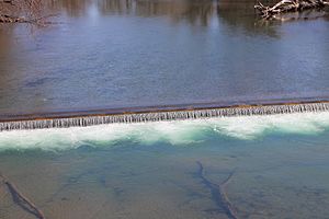
It's possible to go paddling (like kayaking or canoeing) on much of Catawissa Creek during certain times of the year. However, it's usually not possible to paddle during the summer months. Upstream from Mainville, there are some riffles (shallow, rocky areas) and small rapids. There's a larger rapid downstream of a small dam in the lower parts of the creek.
 | Bessie Coleman |
 | Spann Watson |
 | Jill E. Brown |
 | Sherman W. White |


