
Scotch Run (Catawissa Creek tributary) facts for kids
Quick facts for kids Scotch Run |
|
|---|---|

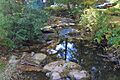
Scotch Run at Mifflin Cross Roads
|
|


|
|
| Physical characteristics | |
| Main source | lake in a valley in Beaver Township, Columbia County, Pennsylvania 1,000 to 1,020 feet (300 to 310 m) |
| River mouth | Catawissa Creek in Main Township, Columbia County, Pennsylvania 558 ft (170 m) 40°57′46″N 76°21′28″W / 40.96287°N 76.35776°W |
| Length | 7.8 mi (12.6 km) |
| Basin features | |
| Progression | Catawissa Creek → Susquehanna River → Chesapeake Bay |
| Basin size | 9.10 sq mi (23.6 km2) |
Scotch Run is an important stream in Columbia County, Pennsylvania. It flows into Catawissa Creek. The stream is about 7.8 miles (12.6 km) long. It runs through Beaver Township and Main Township.
The area of land that drains into Scotch Run is about 9.10 square miles (23.6 km2). The water in the stream is naturally a bit acidic and doesn't have many nutrients. Scotch Run is about 7.2 feet (2.2 m) wide at its start. It gets wider downstream, reaching about 17.0 feet (5.2 m) near its end. It flows between two mountains: Nescopeck Mountain and McCauley Mountain.
Most of Scotch Run is close to a road. However, only a small part is very close to one. A section of Pennsylvania State Game Lands Number 58 is in the area around the stream. There are also special temporary pools of water called "ephemeral natural pools" nearby. The Pennsylvania Fish and Boat Commission studied the stream in 1977. Scotch Run is known as a good place for "Coldwater Fishery" and "Migratory Fishery." This means it's a good home for fish that like cold water and fish that travel.
In 1997, scientists found three types of fish near the start of the stream. They found eight types of fish closer to where it ends. Both areas had brown trout and brook trout. Along the stream, there's a forest with hemlock trees and other hardwoods.
Contents
Where Scotch Run Flows
Scotch Run starts in a small lake in a valley. This is in eastern Beaver Township. It flows west and a little south for several miles. It runs between Nescopeck Mountain and McCauley Mountain.
The stream then goes through a small town called Mifflin Cross Roads. After this, it briefly turns south. Then it turns west-southwest again. It flows between Nescopeck Mountain and Dry Ridge. Soon after, the stream leaves Beaver Township. It enters Main Township.
In Main Township, Scotch Run flows between Nescopeck Mountain and Full Mill Hill. This is for a bit more than half a mile. Finally, it joins Catawissa Creek. Scotch Run meets Catawissa Creek about 8.30 miles (13.36 km) before Catawissa Creek reaches its own end.
Smaller Streams Joining Scotch Run
Scotch Run does not have any named smaller streams that flow into it. However, it does have one unnamed stream. This stream is sometimes called "Trib 27547 to Scotch Run." It flows into Scotch Run from the right side.
Water Quality
Scotch Run's water is naturally a bit acidic and doesn't have many nutrients. This means it could be affected by acid rain.
In June 1997, scientists measured the water temperature of Scotch Run. At one spot, it was 15.1°C (59.2°F). Further downstream, it was 14.7°C (58.5°F). Near its mouth, it was 15.0°C (59.0°F).
The pH of the water tells us how acidic or basic it is. A pH of 7 is neutral. Lower numbers are more acidic. Higher numbers are more basic. In Scotch Run, the pH was measured between 6.6 and 7.0. This means it's slightly acidic to neutral. The water also has a small amount of alkalinity, which helps to balance the pH. The water's hardness was measured between 15 and 23 milligrams per liter.
Land and Rocks Around the Stream
The land near the end of Scotch Run is about 554 feet (169 m) above sea level. The stream starts at a higher elevation, between 1000 and 1020 feet (300 and 310 m) above sea level.
Near its start, Scotch Run is about 7.2 feet (2.2 m) wide. The land here slopes down about 23 feet per mile (4.4 m/km). Further downstream, the stream gets wider, about 16.9 feet (5.2 m). The slope here is steeper, dropping about 141 feet per mile (26.7 m/km).
Scotch Run flows over a type of rock called the Mauch Chunk Formation. However, the small unnamed stream that joins it starts on Pocono Formation rock. Other rock types like the Spechty Kopf Formation and Pottsville Formation are also found nearby.
The stream flows over a type of soil called Leck Kill soil. This soil is deep and drains water well. On the edges of the area around the stream, there is Hazleton soil. This is also a deep, well-drained soil.
Scotch Run flows through a place called Scotch Valley. This valley is narrow, but it gets a bit wider after Mifflin Cross Roads. There is a small pond or lake where the stream begins. Some wetland areas are also found near the stream. The stream is surrounded by a 100-year floodplain along its whole length. This means the area could flood about once every 100 years.
The Area Around Scotch Run
The entire area that drains into Scotch Run is about 9.10 square miles (23.6 km2). Most of this area is in Beaver Township. A smaller part near the end of the stream is in Main Township. The northern edge of this area is the border between Beaver Township and Mifflin Township.
The mouth of Scotch Run is in the Shumans United States Geological Survey map area. Its source is in the Nuremberg map area. Part of the stream flows through Pennsylvania State Game Lands Number 58.
In the upper part of Scotch Run, about 24% of the stream is within 328 feet (100 m) of a road. In the lower part, about 23% is within 328 feet (100 m) of a road. In 1990, not many people lived near the stream. It flows mostly through quiet, rural areas.
The upper part of Scotch Run is mostly closed to the public. Because of this, a 1997 report said it wasn't great for recreation. However, the lower part of the stream offers good recreational chances. The report also said that neither part of the stream was very good for fishing.
The upper areas around Scotch Run are mostly forests. But there are some homes near the stream's start. Downstream of Mifflin Cross Roads, there are both forests and farm land. The forests are mostly on the hillsides. The valley bottom has many small farms. A road called Scotch Valley Drive follows the stream. Another road, LR 19015, also runs alongside it.
There are special temporary pools of water near Scotch Run. These are called "ephemeral natural pools." In the past, a reservoir was made on the stream by building a dam. Today, there are homes and roads near the stream. Dirt roads can break up the forests and pools. All Terrain Vehicles (ATVs) might also harm the area. These pools can also be breeding spots for mosquitos.
The end of Scotch Run is near Mainville.
History of Scotch Run
Scotch Run was officially added to the Geographic Names Information System on August 2, 1979. Its special ID number is 1187155.
Because of the hills and valleys around Scotch Run, the area was settled later than other nearby places. Alexander McCauley was one of the first settlers in Beaver Township in 1774. Before 1820, a mill for processing wool was built on the stream by George Fleming. In 1820, this mill became a school run by Jacob Gensel.
The Sunbury Hazleton, and Wilkes-Barre Railroad used to follow the bank of Scotch Run. The stream was historically known as a good place for trout fishing.
The Pennsylvania Fish and Boat Commission studied Scotch Run in 1977. Scientists also took water samples from the stream's mouth in 1966.
Two bridges more than 20 feet (6.1 m) long have been built over Scotch Run. One is a steel girder bridge from 1911. It is 26.9 feet (8.2 m) long. The other is a concrete culvert bridge from 1974, also 26.9 feet (8.2 m) long.
Animals and Plants of Scotch Run
The entire area that drains into Scotch Run is special. The Pennsylvania Department of Environmental Protection calls it a "Coldwater Fishery" and a "Migratory Fishery." This means it's important for cold-water fish and fish that travel. The Pennsylvania Fish and Boat Commission puts adult trout into the stream. Local clubs also add trout to the stream. In 1997, a study found both wild brook trout and brook trout from hatcheries in the stream.
In 1997, fish like brook trout, brown trout, and white suckers lived in the upper part of Scotch Run. Twenty years before, pumpkinseeds and eastern blacknose dace were also there, but not brown trout. Scientists don't know why the blacknose dace disappeared. The pumpkinseeds were only there because they escaped from nearby farm ponds.
The lower part of Scotch Run had eight kinds of fish in 1997. These included bluegills, brook trout, brown trout, blacknose dace, creek chubs, longnose dace, pumpkinseeds, and white suckers. Bluegills and longnose dace were not there two decades earlier. But rainbow trout and golden shiners were present then. The rainbow trout disappeared because they were no longer stocked. The golden shiners were only there because people accidentally introduced them.
Many wild trout live in Scotch Run. In the upper parts, there are about 66 brook trout and 3 brown trout per kilometer. In the lower parts, there are even more, with about 487 brook trout per kilometer.
Amphibians use the temporary pools near Scotch Run as a place to lay their eggs. Amphibians found here include spring peepers, spotted salamanders, and wood frogs.
A special forest grows near Scotch Run. It has hemlock trees and other hardwood trees. This forest includes wetlands and temporary pools called vernal pools. Some trees you might see are white oak, red oak, tulip poplar, yellow birch, American beech, and red maple. Other plants include teaberry, sphagnum moss, wood anemone, false hellebore, skunk cabbage, goldthread, and sensitive fern.
Experts suggest creating a special green area called a riparian buffer along Scotch Run. This would help protect the stream. They also recommend stopping new buildings and limiting All Terrain Vehicle use in the area.
Images for kids
-
Scotch Run at Mifflin Cross Roads
