McCauley Mountain (Pennsylvania) facts for kids
Quick facts for kids McCauley Mountain |
|
|---|---|
| McAuley Mountain, McCauley's Mountain | |

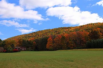
McCauley Mountain from the northwest
|
|
| Highest point | |
| Elevation | 1,571 ft (479 m) |
| Geography | |
| Topo map | Shumans, Nuremberg |
| Geology | |
| Mountain type | synclinal mountain |
McCauley Mountain, also known as McAuley Mountain, is a cool mountain in Columbia County, Pennsylvania, in the United States. It stands tall at about 1,571 feet (479 m) above sea level. This mountain is special because it's a "synclinal" mountain. This means its rock layers dip inward like a bowl.
You can find interesting rock layers here, like the Mauch Chunk Formation and the Pottsville Formation. There are also lots of coal deposits on the mountain. People discovered coal here in 1826, and mining started in the 1850s. However, trying to mine coal on the east side of the mountain didn't work out well financially.
McCauley Mountain has several ponds. Some were made by mining activities, but others are natural "vernal pools." These are temporary ponds that fill with water in spring. Some ponds are surrounded by tall hemlock trees and other leafy trees that lose their leaves in fall. Important streams nearby include Scotch Run, Beaver Run, and Catawissa Creek. The mountain got its name from Alexander McCauley, who settled in the area in 1774.
Contents
Exploring McCauley Mountain's Location and Weather
McCauley Mountain is about 1,571 feet (479 m) high. This makes it the ninth tallest mountain in Columbia County, not counting long ridges.
You can find the mountain's exact location on maps from the United States Geological Survey. It's mostly in northern Beaver Township. The mountain is about 9 miles (14 km) east of the town of Catawissa.
There are many wetlands and ponds on McCauley Mountain. Some of these are natural, while others were likely created by old mining activities. These mining activities have changed the look of some parts of the mountain.
McCauley Mountain is a synclinal mountain. This means its rock layers fold downwards, forming a trough shape. A nearby area called the Catawissa-McCauley Mountain Synclinorium borders another rock structure called the Berwick anticlinorium.
Several streams flow near McCauley Mountain. Scotch Run flows between McCauley Mountain and Nescopeck Mountain. Beaver Run flows between McCauley Mountain and Buck Mountain. The larger Catawissa Creek also flows close by, where Beaver Run joins it.
An old book from 1915 described a spot on McCauley Mountain as "one of the coldest spots in the township [Beaver Township] in winter." So, it can get quite chilly there!
Understanding McCauley Mountain's Rocks and Coal
McCauley Mountain is surrounded by a type of rock called the Mauch Chunk Formation. This rock layer is very thick here, at least 2,000 feet (610 m) deep. You can also see parts of a rocky material called the Pottsville Formation on the mountain's surface. The top of McCauley Mountain has many deposits of coal.
There's a special area on the mountain called the McCauley Basin. This basin holds coal and is about 4 miles (6.4 km) northwest of another coal area called the Roberts Run Basin. The part of the McCauley Basin that has useful coal is about 2 miles (3.2 km) long and 0.25 to 0.33 miles (0.40 to 0.53 km) wide. It contains two layers of coal, which are likely part of the Lower White-Ash Group. In the middle of the mountain, there's a large area where old mining lands have been partially restored. You can also find dry strip mines and piles of waste rock called spoil piles.
Near the eastern end of McCauley Mountain, there's a sign of an ice lobe from the Illinoian Ice Age. This shows that glaciers once reached this area.
History and Naming of McCauley Mountain
Alexander McCauley was one of the first European settlers in Beaver Township. He moved to the area near McCauley Mountain in 1774. The mountain was named after him in the late 1700s or early 1800s. The United States Board on Geographic Names officially decided on the mountain's name in 1909. It was added to the Geographic Names Information System on August 2, 1979.
People discovered coal deposits on McCauley Mountain as early as 1826. Many mining operations took place on the mountain during the 1800s. The McCauley Railroad Company was started in 1854 and built a railroad in 1855 and 1856. This railroad ran for 5 miles (8.0 km) from the Catawissa Railroad to the coal fields on the mountain. The McCauley Railroad Company later joined with the Columbia Iron and Coal Company in 1858. Mining officially began in 1858.
Trying to mine coal on the eastern side of McCauley Mountain turned out to be a big challenge for all the companies that tried it. However, the McCauley Colliery operated on the mountain from 1873 to 1876. The Glen City Colliery also had operations there. Mining continued into the 20th century, at least until 1911. One mine, called the Glen City mine, was located south of the community of Glen City.
Historically, there were several farms on McCauley Mountain. In the early 1900s, H. M. Hess owned one of them. As late as the 1910s, the St. Peter's Evangelical Lutheran Church was located on the side of the mountain. It was the only church building in southern Columbia County at that time.
As of 2004, there's a chance that new utility lines and communication towers might be built on McCauley Mountain. The Columbia County Natural Areas Inventory suggests that all terrain vehicle trails should not be built near the ponds on the mountain to protect the natural environment.
Wildlife and Nature on McCauley Mountain
McCauley Mountain is considered a "Locally Significant Site" on the Columbia County Natural Areas Inventory. This means it's an important natural area. Its priority rank is 5 on a scale of 1 to 5, with 1 being the most important.
Many of the ponds on McCauley Mountain are surrounded by hemlock trees and other deciduous trees. These areas of deciduous forest are mostly untouched and natural.
 | James Van Der Zee |
 | Alma Thomas |
 | Ellis Wilson |
 | Margaret Taylor-Burroughs |


