Little Catawissa Creek facts for kids
Quick facts for kids Little Catawissa Creek |
|
|---|---|

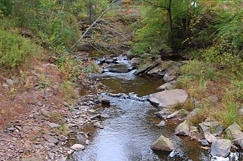
Little Catawissa Creek looking upstream immediately above the mouth of the tributary Stony Run
|
|
| Physical characteristics | |
| Main source | valley in Conyngham Township, Columbia County, Pennsylvania 1,360 to 1,380 feet (410 to 420 m) |
| River mouth | Catawissa Creek in North Union Township, Schuylkill County, Pennsylvania 833 ft (254 m) 40°53′24″N 76°12′33″W / 40.8901°N 76.2092°W |
| Length | 10.8 mi (17.4 km) |
| Basin features | |
| Progression | Catawissa Creek → Susquehanna River → Chesapeake Bay |
| Basin size | 16.70 sq mi (43.3 km2) |
| Tributaries |
|
Little Catawissa Creek is a stream in Pennsylvania, USA. It flows into a bigger stream called Catawissa Creek in Columbia and Schuylkill Counties. It's about 10.8 miles (17.4 km) long and winds through several townships. Smaller streams like Stony Run and Trexler Run flow into it.
The creek's water is a little bit acidic, but it helps make the water quality better in Catawissa Creek. The land around Little Catawissa Creek is mostly made of certain types of rock formations. The main soils in the area are called Leck Kill and Hazleton soil. The area that drains into the creek, called its watershed, covers about 16.70 square miles (43.3 km2). Many bridges cross the creek, and roads often run alongside it.
Little Catawissa Creek is a great place for fish! It's known as a High-Quality Coldwater Fishery, which means it has clean, cold water perfect for fish. Some parts are even special "Class A Wild Trout Waters," where wild trout live and reproduce naturally. Many different kinds of fish live here, including brook trout and brown trout. The Pennsylvania Fish and Boat Commission has studied the creek many times to check on its health and fish populations.
Contents
Where Does Little Catawissa Creek Flow?
Little Catawissa Creek starts in a narrow valley in Conyngham Township. It flows east for a few miles, following a road called Aristes Ringtown Road. Soon, it leaves Columbia County.
The creek then enters Union Township in Schuylkill County. It keeps flowing east, and its valley becomes narrower. After a few miles, it turns northeast and passes through a small ridge. It then turns north-northeast. About a mile later, it meets its first named smaller stream, Trexler Run.
From there, the creek turns sharply east-northeast. It then starts to meander, or curve, northeast for a few miles, picking up another stream called Stony Run. Finally, it meanders east, briefly entering North Union Township before going back into East Union Township. Soon after, it turns north-northeast and enters North Union Township again. A short distance downstream, it joins the larger Catawissa Creek.
Little Catawissa Creek joins Catawissa Creek about 24.24 miles (39.01 km) upstream from where Catawissa Creek flows into another body of water.
Smaller Streams Joining the Creek
Little Catawissa Creek has several smaller streams, or tributaries, that flow into it. The main ones are Stony Run and Trexler Run. There's also an unnamed stream.
- Stony Run flows through Union Township, Schuylkill County. It joins Little Catawissa Creek about 1.96 miles (3.15 km) upstream from its mouth. Its watershed covers about 2.24 square miles (5.8 km2).
- Trexler Run flows through Roaring Creek Township, Columbia County, and Union Township, Schuylkill County. It joins Little Catawissa Creek about 4.24 miles (6.82 km) upstream from its mouth. Its watershed covers about 3.81 square miles (9.9 km2).
Understanding the Creek's Water
The water in the upper parts of Little Catawissa Creek is not very rich in nutrients. It is also slightly acidic. When this water flows into Catawissa Creek, it helps balance the acidity of the larger creek, which improves the water quality downstream.
The water's pH, which tells us how acidic or basic it is, changes along the creek. In some upper parts, the pH is around 6.4, which is slightly acidic. In other sections, the pH is between 6.8 and 7.0, which is closer to neutral. The "hardness" of the water, which means how many minerals are dissolved in it, also varies.
Scientists have measured the water and air temperatures at different spots along the creek. For example, in June 1997, the water temperature was around 19.8 °C (67.6 °F) in one spot and 17.1 °C (62.8 °F) in another. These measurements help experts understand the creek's health.
Land and Rocks Around the Creek
The land where Little Catawissa Creek starts is high up, between 1,360 feet (410 m) and 1,380 feet (420 m) above sea level. Where it joins Catawissa Creek, the elevation is lower, about 833 feet (254 m).
The creek flows over a type of rock called the Mauch Chunk Formation for almost its entire length. Other rock types, like the Pocono Formation and Pottsville Formation, are found in different parts of the surrounding area.
The creek mostly flows over a soil type called Leck Kill soil. However, its starting point and some western and southern areas have Hazleton soil.
Some areas along Little Catawissa Creek and its smaller streams can experience flooding. There's also an old, flooded strip mine in the western part of the creek's watershed. The creek starts on a mountain called Big Mountain and is a "freestone stream," meaning its water flows over natural rock and soil, not through man-made channels.
The width of the creek changes along its path. In its upper parts, it's about 3.0 metres (9.8 ft) wide, growing to about 6.2 metres (20 ft) wide closer to its mouth. The slope of the creek bed, called the gradient, also varies, affecting how fast the water flows.
The Creek's Surroundings
The area that drains into Little Catawissa Creek, its watershed, covers about 16.70 square miles (43.3 km2). Most of this area is in Union Township, Schuylkill County, but parts are also in Columbia County.
Important roads in the watershed include Zion Grove Road, Little Mountain Road, and Aristes Road. Pennsylvania Route 42 also runs along the western edge of the watershed. Most of the creek is quite close to a road, making it fairly accessible.
In 1990, the number of people living in the watershed varied, with about 30 to 40 people per square kilometer in different sections. Some parts of the creek are closed to public access.
There are some farms in the middle parts of the watershed, though most are small. The towns of Aristes and Ringtown are the main places where people live in the watershed. The Pennsylvania Department of Environmental Protection has given out a few permits for mining on a ridge in the northern part of the watershed. Other parts of the land are covered by private forests and rural homes.
A reservoir called the Ringtown Reservoir is located on a smaller stream that flows into Little Catawissa Creek.
History and Name
Little Catawissa Creek gets its name because it is smaller than the nearby Catawissa Creek.
In the past, the creek was stocked with trout by the Pennsylvania Fish and Boat Commission. This means they would add trout to the creek to help with fishing. The commission has studied the creek many times since 1936 to check on its fish populations.
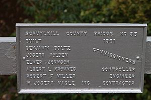
Many bridges have been built over Little Catawissa Creek over the years. Some of these bridges were built in 1914, 1930, 1961, 1973, and 1990. They are made of different materials like steel, concrete, and prestressed box beams.
In 1853, a man named John Mourey built a sawmill and a gristmill on the creek. In the early 1900s, Little Catawissa Creek was even used as an emergency water supply.
Amazing Aquatic Life
The Pennsylvania Department of Environmental Protection considers Little Catawissa Creek a High-Quality Coldwater Fishery in its upper parts, meaning it's excellent for cold-water fish. Further downstream, it's still a Coldwater Fishery. The Pennsylvania Fish and Boat Commission also calls the upper parts "Class A Wild Trout Waters," which means wild trout live and reproduce there naturally.
Wild brook trout are known to reproduce in Little Catawissa Creek. While rainbow trout were once stocked here, it's now forbidden to introduce them. Sadly, river chubs, another type of fish, used to live in the creek but have disappeared for unknown reasons.
Scientists have found many different kinds of fish in the creek. In the upper parts, you might find brook trout, creek chub, and eastern blacknose dace. Further downstream, more species appear, including brown trout and green sunfish. In 1976, a survey found eight fish species, including brown trout, near the creek's mouth.
The "biomass" of wild trout, which is the total weight of trout in a certain area, has been measured. In the upper parts, there's a good amount of wild trout, especially brook trout. In other sections, there are more brown trout. These measurements help experts understand how many fish are living in the creek.
For example, in one section, there are about 799 brook trout per square kilometer that are smaller than 175 millimeters. In another section, there are many brown trout.
A report from 1997 said that Little Catawissa Creek wasn't the best place for fishing, but it's still a very important habitat for many aquatic creatures. The creek is home to a wide variety of aquatic macroinvertebrates, which are tiny animals without backbones that live in the water. This diverse population shows that the creek is a healthy ecosystem.
 | Dorothy Vaughan |
 | Charles Henry Turner |
 | Hildrus Poindexter |
 | Henry Cecil McBay |


