Trexler Run facts for kids
Quick facts for kids Trexler Run |
|
|---|---|

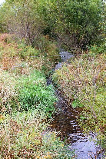
Trexler Run looking upstream from Pine Swamp Road
|
|
| Physical characteristics | |
| Main source | valley on Little Mountain in Roaring Creek Township, Columbia County, Pennsylvania 1,560 ft (480 m) |
| River mouth | Little Catawissa Creek in Union Township, Schuylkill County, Pennsylvania 1,000 ft (300 m) 40°51′51″N 76°15′13″W / 40.86423°N 76.25360°W |
| Length | 3.4 mi (5.5 km) |
| Basin features | |
| Progression | Little Catawissa Creek → Catawissa Creek → Susquehanna River → Chesapeake Bay |
| Basin size | 3.4 sq mi (8.8 km2) |
Trexler Run is a small stream, also called a 'run,' that flows into Little Catawissa Creek. It's located in Columbia County and Schuylkill County, both in Pennsylvania, United States. The stream is about 3.4 miles (5.5 km) long. It flows through Roaring Creek Township in Columbia County and Union Township in Schuylkill County. The area of land that drains into it, called its watershed, is about 3.81 square miles (9.9 km2). Trexler Run is known for its very clean, cold water, which makes it a great home for fish, especially wild trout. Both brook trout and brown trout live here, along with other fish species.
Contents
Where Trexler Run Flows
Trexler Run starts in a valley on a place called Little Mountain. This is in Roaring Creek Township, Columbia County.
- It flows south-southeast for a short distance.
- Then, it leaves Columbia County and enters Union Township, Schuylkill County.
- The stream continues south-southeast, crossing State Route 4036.
- It then meets a smaller, unnamed stream and turns east into a valley.
- After a while, it crosses State Route 4036 again and keeps flowing east and a little north.
- Finally, Trexler Run turns north for a bit before heading east-northeast.
- After flowing for just over a mile, it joins Little Catawissa Creek.
Trexler Run meets Little Catawissa Creek about 4.24 miles (6.82 km) before Little Catawissa Creek reaches its own end.
Stream Water Quality
The water in Trexler Run is not very fertile, meaning it doesn't have a lot of nutrients. It's also slightly acidic. This means it could be affected by acid rain.
- In 1985, the water's alkalinity (how well it can resist becoming acidic) was 4 milligrams per liter.
- By 1997, this measurement increased to 10 milligrams per liter.
- The pH of the stream was 6.4 in 1985 and 6.6 in 1997. A pH of 7 is neutral, so these numbers show it's slightly acidic.
- The hardness of the water is 15 milligrams per liter.
On a summer day in 1997, the air temperature near the stream was 28 °C (82 °F). The water temperature at that spot was 16.3 °C (61.3 °F).
The amount of water flowing in Trexler Run, called its discharge, has been measured many times.
- The flow has ranged from 0.210 to 1.70 cubic feet per second.
- On average, the stream flows at 0.60 cubic feet per second.
- The highest yearly flow between 1959 and 1980 varied a lot. It was 8.80 cubic feet per second in 1965 and jumped to 487 cubic feet per second in 1972.
Land and Rocks Around the Stream
The land around Trexler Run has interesting features and different types of rocks.
- Near where Trexler Run joins Little Catawissa Creek, the land is about 1,000 feet (300 m) above sea level.
- Where the stream starts, its source, the elevation is about 1,560 feet (480 m) above sea level.
Most of Trexler Run flows over rocks from the Mauch Chunk Formation.
- However, the very beginning of the stream is on rocks from the Pocono Formation.
- Other rock types, like the Pottsville Formation, are found in the southern part of the area that drains into the stream.
- The main soil type in the southern and central parts of the watershed is called Leck Kill soil.
- In the northern part, including where the stream begins, the soil is Hazleton soil.
The stream's source is on a mountain called Little Mountain. The entire area around the stream is surrounded by ridges and has many valleys. There's also a sandy area called the Hill, which was formed by glaciers long ago. This Hill has pushed the stream to flow south, making a wide loop around it. In this area, the stream has a narrow channel that cuts 40 feet (12 m) deep into the solid rock.
Some small areas in the Trexler Run watershed can experience flooding. Trexler Run is a small stream, about 3.7 metres (12 ft) wide. It flows downhill at a gentle slope of 12.6 meters for every kilometer it travels.
The Trexler Run Watershed
The watershed of Trexler Run covers an area of 3.81 square miles (9.9 km2). Most of this area is in Union Township, Schuylkill County, but a good part of it is also in Roaring Creek Township, Columbia County.
- Trexler Run flows through farmland for much of its path. These farms are mostly in the valleys of the watershed.
- Forests cover the ridges that surround the stream's watershed.
- Some parts of the northern watershed are protected forests.
Major roads, like Little Mountain Road, are found in the watershed.
- About 64 percent of the stream's length is within 100 metres (330 ft) of a road.
- 89 percent of its length is within 300 metres (980 ft) of a road.
- The entire stream is within 500 metres (1,600 ft) of a road.
- In 1990, about 23 people lived in each square kilometer of the watershed.
Half of Trexler Run flows through private land where people are allowed to fish. The other half is on private land where fishing is not allowed.
History of Trexler Run
Experts have studied Trexler Run three times to learn about its fish and water.
- The first study was in 1932. It suggested not adding more fish to the stream because it was so small.
- A second study in 1939 also recommended against adding fish because people couldn't easily access the stream.
- However, between 1940 and 1957, young brown trout and brook trout were added to the stream five times.
- The third study was done in 1985.
A special bridge was built over Trexler Run in 1989. This bridge is 23.0 feet (7.0 m) long and carries Pine Swamp Road.
Fish and Wildlife
Trexler Run is a very important place for fish.
- The Pennsylvania Department of Environmental Protection considers it a "High-Quality Coldwater Fishery." This means its cold, clean water is perfect for fish.
- It's also called "Class A Wild Trout Waters" by the Pennsylvania Fish and Boat Commission. This means it has a healthy population of wild trout that reproduce naturally.
- A report in 1997 suggested that no more fish should be added to the stream, as it already has a strong wild population.
Seven different kinds of fish live in Trexler Run.
- These include brook trout, brown trout, pumpkinseeds, and largemouth bass.
- The largemouth bass likely came from nearby farm ponds.
- Six of these seven fish species were already living in the stream before 1997.
The amount of wild trout living in the stream, called their biomass, has been measured.
- In 1984, there were 85.19 kilograms of wild trout per hectare. Most of these were brown trout (81.18 kg/hectare), with fewer brook trout (4.01 kg/hectare).
- By 1997, the total wild trout biomass had decreased to 50.85 kilograms per hectare.
The brook trout in Trexler Run can be from 50 to 249 millimeters long. The brown trout can be from 25 to 349 millimeters long.
- There are about 354 wild trout per kilometer that are shorter than 175 millimeters.
- About 97 wild trout per kilometer are longer than 175 millimeters.
A 1997 report said that Trexler Run is an excellent place for angling (fishing). It's one of only two streams in the larger Catawissa Creek area that has a good number of brown trout.
 | Sharif Bey |
 | Hale Woodruff |
 | Richmond Barthé |
 | Purvis Young |


