Cherry Run (South Branch Bowman Creek tributary) facts for kids
Quick facts for kids Cherry Run |
|
|---|---|

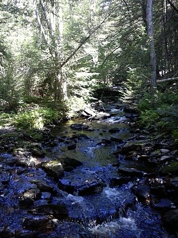
Cherry Run from the Little Cherry Run Trail
|
|
| Physical characteristics | |
| Main source | Cherry Ridge in Fairmount Township, Luzerne County, Pennsylvania between 2,280 and 2,300 feet (695 and 701 m) |
| River mouth | South Branch Bowman Creek near Mountain Springs in Ross Township, Luzerne County, Pennsylvania 1,900 ft (580 m) 41°20′20″N 76°14′35″W / 41.33886°N 76.24310°W |
| Length | 2.1 mi (3.4 km) |
| Basin features | |
| Progression | South Branch Bowman Creek → Bowman Creek → Susquehanna River → Chesapeake Bay |
| Basin size | 1.65 sq mi (4.3 km2) |
| Tributaries |
|
Cherry Run is a small stream in Luzerne County, Pennsylvania, USA. It flows into another stream called South Branch Bowman Creek. Cherry Run is about 2.1 miles (3.4 km) long. It runs through Fairmount Township and Ross Township. This stream is known for its beautiful waterfalls, called cascades. You can also find wild trout living in its waters.
Contents
Where Cherry Run Flows
Cherry Run starts high up on Cherry Ridge in Fairmount Township. It flows towards the southeast, passing through wet, marshy areas known as wetlands. The stream then turns and flows south-southeast, going through more wetlands.
As it continues, Cherry Run turns east-southeast. It picks up water from a smaller stream that joins it from the right side. This area also has a wetland with a small pond. The stream then flows south-southeast again. Here, the valley around the stream becomes narrower and deeper. Another small stream joins Cherry Run from the right. Finally, Cherry Run meets and joins South Branch Bowman Creek.
Land and Rocks Around the Stream
The land near where Cherry Run joins South Branch Bowman Creek is about 1,900 feet (579 meters) above sea level. Where Cherry Run begins, it is much higher, between 2,280 and 2,300 feet (695 and 701 meters) above sea level.
The ground around the upper part of Cherry Run is mostly made of a type of soil called Wisconsinan Till. This area also has wetlands and a peat bog, which is a very wet, spongy area. As the stream flows lower, the ground changes. You'll find more bedrock made of sandstone and shale. Near the mouth of the stream, there are also areas of alluvial fan and alluvium. These are deposits of sand and gravel left by flowing water.
Cherry Run is famous for its many small cascades. These are like mini-waterfalls where the water tumbles over rocks. The stream also flows through a narrow, deep valley called a glen.
Cherry Run's Water Area
The area of land that drains water into Cherry Run is called its watershed. This watershed covers about 1.65 square miles (4.27 square kilometers). The end of Cherry Run is located in the Sweet Valley area on maps. However, its beginning is in the Red Rock area. The stream's mouth is close to a place called Mountain Springs.
The entire length of Cherry Run is located inside Ricketts Glen State Park. This means it's part of a protected natural area.
History and Fun Activities
Cherry Run was officially added to the Geographic Names Information System on August 2, 1979. This system keeps track of names and locations of places in the United States.
People who have visited Cherry Run describe it as "incredibly beautiful" and "phenomenal." This was written in a book by Jeff Mitchell called Hiking the Endless Mountains. There's a hiking trail in Ricketts Glen State Park called the Cherry Run Trail. This trail crosses over Cherry Run, making it a great spot for hikers to explore.
Wildlife in Cherry Run
Wild trout live and reproduce naturally in Cherry Run. You can find them from the very beginning of the stream all the way to its mouth. The areas around the stream are also home to thick forests. These forests are filled with hemlock trees.
 | Delilah Pierce |
 | Gordon Parks |
 | Augusta Savage |
 | Charles Ethan Porter |

