
Bowman Creek facts for kids
Quick facts for kids Bowman Creek |
|
|---|---|

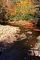
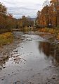
Bowman Creek looking downstream near its mouth
|
|
| Other name(s) | Bowmans Creek, Bowman's Creek |
| Physical characteristics | |
| Main source | confluence of North Branch Bowman Creek and South Branch Bowman Creek in Ross Township, Luzerne County, Pennsylvania between 1,840 and 1,860 feet (561 and 567 m) |
| River mouth | Susquehanna River in Eaton Township, Wyoming County, Pennsylvania 584 ft (178 m) 41°30′59″N 75°56′39″W / 41.5165°N 75.9442°W |
| Length | 26.4 mi (42.5 km) |
| Basin features | |
| Progression | Susquehanna River → Chesapeake Bay |
| Basin size | 120 sq mi (310 km2) |
| Tributaries |
|
Bowman Creek is a stream in Luzerne County and Wyoming County, Pennsylvania. It flows into the Susquehanna River. The creek is about 26 miles (42 km) long. It flows through several townships, including Ross, Lake, Noxen, Monroe, and Eaton.
The area around Bowman Creek is mostly covered by forests, making up almost 90 percent of its land. There are also some meadows and farms. Most buildings are found along the main roads. The creek has flooded sometimes, but usually without much damage. People settled near Bowman Creek in the early 1800s. In the past, industries here included cutting timber, farming, and making leather.
Bowman Creek is known as a great place for fishing, especially for trout. Many of its smaller streams are also good for fish. You can find brook trout, brown trout, and rainbow trout here. Some parts of the creek are even stocked with trout to help fishing. The creek is also a good spot for canoeing. Parts of Bowman Creek are located in Pennsylvania State Game Lands Number 57 and Ricketts Glen State Park.
Contents
Where Bowman Creek Flows

Bowman Creek starts in Ross Township, Luzerne County. It begins where two smaller streams, North Branch Bowman Creek and South Branch Bowman Creek, meet on North Mountain.
The creek first flows northeast, passing a lake and getting water from a stream called Bean Run. Then it turns east for a few miles, where Wolf Run joins it. After that, it flows northeast again, entering Lake Township. Here, Beth Run and Butternut Run add to its waters. The creek then turns north and leaves Luzerne County.
Once in Noxen Township, Wyoming County, Bowman Creek quickly meets Sugar Run and Cider Run. It continues northeast, passing Stone Mountain and getting water from Broad Hollow Run, Windfall Run, and Sorber Run. It then turns north-northeast, picking up Stone Run near the community of Stull.
The creek then flows east through the community of Noxen, where its valley gets wider. In Noxen, York Run, Hettesheimer Run, and Beaver Run join the creek. Leaving Noxen, Bowman Creek enters Monroe Township. It flows north, parallel to Pennsylvania Route 29, and picks up South Run. As it flows between Schooley Mountain and Brier Mountain, Leopard Creek joins it.
Finally, Bowman Creek turns northeast and enters Eaton Township. It flows east, then north, and then east again for several miles before joining the Susquehanna River. Bowman Creek meets the Susquehanna River about 218 miles (351 km) upstream from the Susquehanna's mouth.
Water Quality and Flow
Bowman Creek is considered a healthy stream and is not listed as "impaired." However, some parts of the creek have had problems with acid rain, especially in its upper sections. To help with this, people have added limestone to the creek to make the water less acidic.
During summer, the creek is often shallow and clear. The water in Bowman Creek is like a "freestone stream," meaning it has very few dissolved minerals, like calcium, and its pH (a measure of how acidic or basic water is) is usually close to neutral.
On average, about 89.9 cubic feet (2.55 cubic meters) of water flow through the middle parts of Bowman Creek every second. It takes about 23 hours and 19 minutes for water to travel from the creek's beginning to its middle sections.
In 2010, a company started taking water from Bowman Creek for gas drilling. There were some worries about this, but studies showed it didn't harm the creek's water levels.
Land and Landscape
.JPG)
The land around Bowman Creek changes quite a bit. Near where it joins the Susquehanna River, the creek is about 584 feet (178 m) above sea level. At its very beginning, it's much higher, between 1,840 and 1,860 feet (561 and 567 m) high. The highest point in the whole area around the creek is about 2,470 feet (750 m) high on North Mountain.
In its upper parts, Bowman Creek is quite small, like a brook. But by the time it reaches Noxen, it can be 40 to 60 feet (12 to 18 m) wide. The creek has some deep spots and also fast-flowing, oxygen-rich areas called riffles. Many parts of the creek are shallow enough to wade in, but the currents can be strong at times.
The creek flows through a deep valley that looks a bit like a gorge. You can see a waterfall called Evans Falls, which is 8 feet (2.4 m) high. The land around the creek is generally "rough and hilly," with steep hills in the upper areas and gentler slopes on the valley floor. There are also some small lakes and swamps in the area.
The creek's path is winding, and it flows over sandstone and shale rocks. The most common rock type in the area is the Catskill Formation. There are also different types of soil associations, with the Wellsboro-Morris-Oquaga and Oquaga-Lackawanna-Arnot associations being the most common.
A special place called the Bowman Creek Ledges is found along the creek in Eaton Township. These ledges are made of sandstone and shale and are known for their beautiful views and many different kinds of plants.
Several dams are in the Bowman Creek area, like Lake Catalpa Dam and Beech Lake Dam. Some parts of the creek have been straightened by people, which is called channelization. The amount of rain in the area each year is usually between 45 and 55 inches (110 and 140 cm).
The Bowman Creek Area

The entire area that drains into Bowman Creek, called its watershed, covers about 120 square miles (310 km²). This watershed is located in northwestern Luzerne County and southern Wyoming County.
Most of the land in the Bowman Creek watershed is forested, making up about 83 percent of the area. About 10 percent is meadows, and a smaller amount is used for agriculture. Most of the homes and businesses are found along the main roads like Pennsylvania Route 29, Pennsylvania Route 292, and Pennsylvania Route 309.
There are also many wetlands in the watershed. While some forests are on private land, much of the creek upstream of Noxen flows through forested areas. Downstream of Noxen, the creek passes through a mix of forests, farms, and small towns.
Bowman Creek has experienced floods from time to time. For example, a big flood in 1850 washed away many buildings. More recently, in the 2000s, the creek and its smaller streams were damaged by major floods, including one caused by Hurricane Irene in 2011. However, because not many buildings are in the flood-prone areas, the damage is usually not too severe.
History and Past Uses

Bowman Creek has been on maps since at least 1791. By the early 1800s, a few settlers had moved into the creek's valley. One of the first settlers in Monroe Township, Josiah Newberry, arrived on the creek in 1813. The first post office in Monroe Township was even named after Bowman Creek.
In the late 1800s, the area was busy with lumbering. Companies bought large areas of timberland near the creek. Before railroads arrived in the early 1890s, lumber was moved using splash dams (small dams that could be opened to create a rush of water), creek floods, and wagons. The Lehigh Valley Railroad built a line to Noxen, on Bowman Creek, by 1892. This railroad, called the Bowman's Creek Branch, was used until 1963.
In the early 1900s, other important industries in the watershed included tanneries (places where animal hides are made into leather) and agriculture. The creek's water also powered a gristmill, which grinds grain. Historically, splash dams on the creek also helped supply ice to the nearby Wyoming Valley.
Many bridges have been built over Bowman Creek over the years. For example, a steel truss bridge carrying Pennsylvania Route 29 was built in 1936 and repaired in 1985. More modern bridges were built in the 1990s and 2000s.
A group called the Bowman's Creek Watershed Association works to protect the creek and its surrounding land. They have been active in improving the creek's health.
Wildlife and Nature
Bowman Creek is a special place for fish and other wildlife. The main part of the creek and most of its smaller streams are designated as "High-Quality Coldwater Fishery" and "Migratory Fishery." This means they are excellent habitats for fish that prefer cold water and for fish that travel to spawn.
Wild trout naturally live and reproduce in Bowman Creek from its beginning all the way to its mouth. The creek is also regularly stocked with brook trout, brown trout, and rainbow trout by the Pennsylvania Fish and Boat Commission. Bowman Creek is very famous in the area for being a top trout stream.
In the 1800s, people even tried stocking thousands of California salmon in the creek. Today, wild trout are more common in the smaller streams that flow into Bowman Creek than in the main creek itself. Upstream of Stull, brook trout are most common. Further downstream, brown trout become more common. Wild rainbow trout are also found, often from private hatcheries nearby.
Acid rain used to harm the native brook trout, but they have made a good comeback. You might also see mayflies and Ospreys around the creek.
The Bowman Creek Ledges, a natural feature along the creek, are home to a diverse northeastern hardwood forest. This forest has many different kinds of trees, like beech, hemlock, sugar maple, and yellow birch. You can also find many ferns and wildflowers there, such as Christmas fern and columbine.
Fun Activities

Bowman Creek is a great place for outdoor activities!
You can canoe on about 10.3 miles (16.6 km) of Bowman Creek. The best time to go is during snowmelt or within four days after heavy rain. The creek is rated as a difficulty level of 1 to 2, which means it's good for beginners to intermediate paddlers. The scenery along the creek is described as "fair to good."
Fishing is very popular here. A special 0.8-mile (1.3 km) section of Bowman Creek only allows catch and release fly fishing. The creek is a favorite spot for anglers from nearby cities like Wilkes-Barre and Scranton. It's known as "one of northeastern Pennsylvania's top trout streams."
The upper parts of Bowman Creek flow through Ricketts Glen State Park and Pennsylvania State Game Lands Number 57. These areas offer opportunities for hiking and enjoying nature. While Hunting is not allowed right at the creek's headwaters, it is permitted further downstream in the state park. A road near the creek's headwaters is shared by cars, snowmobiles, and hikers.
There's also a park near Bowman Creek and the Bowman Creek Ledges, which is described as "very scenic."
Images for kids
-
At the confluence of the tributary Beth Run
-
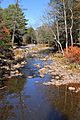
West of Noxen
-
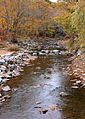
In Noxen
-
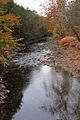
From Pennsylvania Route 292
-
Near its mouth


