
Leonard Creek facts for kids
Quick facts for kids Leonard Creek |
|
|---|---|

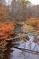
Leonard Creek looking downstream
|
|
| Other name(s) | Leonards Creek, Leonard's Creek |
| Physical characteristics | |
| Main source | Dallas Township, Luzerne County, Pennsylvania between 1,200 and 1,220 feet (366 and 372 m) |
| River mouth | Bowman Creek in Monroe Township, Wyoming County, Pennsylvania 837 ft (255 m) 41°26′26″N 76°01′10″W / 41.4406°N 76.0194°W |
| Length | 7.2 mi (11.6 km) |
| Basin features | |
| Progression | Bowman Creek → Susquehanna River → Chesapeake Bay |
| Basin size | 17.1 sq mi (44 km2) |
| Tributaries |
|
Leonard Creek is a small river, also called Leonards Creek or Leonard's Creek. It flows into Bowman Creek in Luzerne County and Wyoming County, in Pennsylvania, USA. The creek is about 7.2 miles (11.6 km) long. It flows through Dallas Township and Monroe Township.
The area of land that drains into Leonard Creek is about 17.1 square miles (44.3 km2). This creek is known for having clean water. Most of the land around it is covered by forests or used for agriculture. Leonard Creek is an important stream that feeds into Bowman Creek.
In the past, floods have sometimes caused problems along the creek. Many mills used to operate along its banks. Several bridges have also been built over it. The creek's water is very good for fish. It is a special place for coldwater fish and fish that travel to different places. Some parts of its smaller streams are even protected as "Class A Wild Trout Waters."
Contents
The Creek's Journey

Leonard Creek starts its journey in Dallas Township, Luzerne County. It flows southeast for over a mile. As it goes, it passes through a valley and by several small ponds. Then, the creek turns northeast for a short distance. Along this part, two small streams join it from the right side.
Next, it turns north for about a mile. It crosses under Pennsylvania Route 309. At this point, it leaves Dallas Township and Luzerne County. The creek then enters Monroe Township in Wyoming County. It continues flowing north-northwest for a few miles, staying close to Pennsylvania Route 309. Two more small streams join from the right, and one from the left.
After that, the creek turns northwest for a bit. It gets another small stream from the right and one from the left. Then, it turns north-northwest again. Here, the valley around the creek becomes much deeper. Another unnamed stream joins from the right. After flowing for over a mile, the creek leaves its deep valley. It turns north and flows next to Bowman Creek. Finally, after a short distance, it turns northwest and joins Bowman Creek.
Leonard Creek meets Bowman Creek about 10 miles (16.1 km) before Bowman Creek reaches its own end.
Land and Water Around the Creek
The land around Leonard Creek is made of different types of soil and rock. Near the end of the creek, the ground is about 837 feet (255 meters) above sea level. Where the creek begins, the land is higher, between 1,200 and 1,220 feet (366 and 372 meters) above sea level.
Much of the ground along the creek is made of alluvium. This is a type of soil left behind by flowing water. In some areas, you can also find old river terraces, a type of rocky soil called Till, and solid bedrock like sandstone and shale. Further upstream, there are also areas with fan-shaped deposits of soil and even places where sand and gravel are dug up.
The Creek's Surroundings
The entire area that drains water into Leonard Creek is called its watershed. This watershed covers about 17.1 square miles (44.3 km2). The creek flows through areas shown on the Noxen and Center Moreland maps.
Leonard Creek is one of the most important streams that flows into Bowman Creek. Most of the land in the Leonard Creek watershed is covered by forests. However, a good amount of the land is also used for farming.
There are no deep wells drilled in the watershed for water. But there is a pipeline for natural gas near the creek. Some homes and businesses are built in the floodplain of the creek. The village of Kunkle is also located along the creek.
Flooding has caused damage to bridges and the creek's banks in the past. For example, a flood in 2010 badly damaged two bridges and parts of the creek's channel. But money was given by the government to help fix these problems.
A Look Back in Time

Leonard Creek was officially named and added to a national information system in 1979. It has also been known as Leonards Creek or Leonard's Creek for a long time.
Long ago, there were many mills built along Leonard Creek. These mills used the power of the flowing water to do work. For example, a sawmill was built around 1840 about half a mile downstream from Kunkle.
Over the years, many bridges have been built across Leonard Creek. Some of the older bridges include one built in 1914, another in 1934, and two more in 1940. These bridges helped people cross the creek easily. Newer bridges have also been built, like one in 1969 and another in 2009.
In 2010, a big flood caused a lot of damage to the creek's channel. But a local conservation group received money to help repair it. In 2012, a study was done on Leonard Creek and other streams. Scientists looked at tiny water bugs, called macroinvertebrates, to see if gas drilling was affecting the health of the streams.
Animals in the Creek
The area around Leonard Creek is a great place for fish. It's known as a High-Quality Coldwater Fishery and a Migratory Fishery. This means the water is cold and clean enough for fish that like cold water, and also for fish that travel to different places to lay their eggs.
Wild trout naturally live and reproduce in Leonard Creek. They can be found from the upper parts of the creek all the way to its mouth. One of the smaller streams that flows into Leonard Creek is even specially protected. It's called "Class A Wild Trout Waters" for brook trout and brown trout.
Sometimes, rainbow trout are added to the creek by the Pennsylvania Fish and Boat Commission. This helps to keep the fish population healthy. Even as far back as the 1930s, brook trout were put into the creek. Besides fish, other animals like Great blue herons (a type of bird) and salamanders have been seen near the creek.
Scientists have also studied the tiny creatures living in Leonard Creek. In 2012, they found 184 different kinds of macroinvertebrates. These included many types of mayfly larvae, stonefly larvae, beetles, and caddisfly larvae. These small bugs are important because they tell us how healthy the water is.
Images for kids
-
Leonard Creek looking downstream
