
York Run facts for kids
Quick facts for kids York Run |
|
|---|---|

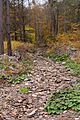
York Run looking upstream near its mouth
|
|
| Physical characteristics | |
| Main source | edge of a plateau in Noxen Township, Wyoming County, Pennsylvania between 2,060 and 2,080 feet (628 and 634 m) |
| River mouth | Bowman Creek in Noxen Township, Wyoming County, Pennsylvania 1,014 ft (309 m) 41°25′39″N 76°04′01″W / 41.42762°N 76.06685°W |
| Length | 2.3 mi (3.7 km) |
| Basin features | |
| Progression | Bowman Creek → Susquehanna River → Chesapeake Bay |
| Basin size | 1.42 sq mi (3.7 km2) |
York Run is a small stream, or tributary, that flows into Bowman Creek in Wyoming County, Pennsylvania. It's about 2.3 miles (3.7 km) long and runs entirely through Noxen Township. The area of land that drains into York Run, called its watershed, covers about 1.42 square miles (3.7 km2). This stream is known for its excellent water quality, making it a great home for fish, especially trout. It's officially recognized as a High-Quality Coldwater Fishery and a Migratory Fishery, and it's also a special "Class A Wild Trout Waters" area.
Contents
Where Does York Run Flow?

York Run starts high up near the edge of a flat, raised area called a plateau in Noxen Township. At first, it flows east-northeast, and its valley quickly gets much deeper.
The stream then turns to flow east-southeast for a while before changing direction again to the south-southeast. After flowing this way for some distance, it reaches the edge of the town of Noxen. York Run then follows the border of Noxen, continuing south-southeast, until it meets and joins Bowman Creek. This meeting point is about 14.00 miles (22.53 km) upstream from where Bowman Creek itself ends.
What is the Water Quality Like in York Run?
York Run is known for its clean water. It is not considered a polluted stream. The water in York Run has a certain level of alkalinity, which helps keep the water stable for aquatic life. This level is about 12 milligrams per liter (0.012 oz/cu ft).
Sometimes, companies need to manage water during construction. For example, Mehoopany Wind Energy once had a plan to manage stormwater that might flow into York Run during their building activities. This helps protect the stream's clean water.
What is the Land Around York Run Like?
The land around York Run varies in height. Where York Run joins Bowman Creek, the elevation is about 1,014 feet (309 m) above sea level. Up at the stream's source, the land is much higher, between 2,060 and 2,080 feet (628 and 634 m) above sea level.
The ground and rocks near the mouth of York Run are mostly made up of alluvium (materials like sand and gravel left by flowing water), alluvial fans (fan-shaped deposits of sediment), and a type of material left behind by glaciers called Wisconsinan Ice-Contact Stratified Drift. Further upstream, you'll find more glacial deposits called Wisconsinan Till and alluvium. However, in these areas, you can also see bedrock made of sandstone and shale poking through the ground.
Who Owns the Land Around York Run?
The entire area that drains into York Run, its watershed, covers about 1.42 square miles (3.7 km2). The stream is located completely within a specific map area known as the United States Geological Survey quadrangle of Noxen.
It's important to know that all of York Run flows through private land. This means that the public cannot access the stream without permission from the landowners.
What Animals and Plants Live in York Run?
The area around York Run is a very important place for fish and other aquatic life. It's designated as a High-Quality Coldwater Fishery, which means its cold, clean water is perfect for fish that prefer cooler temperatures. It's also a Migratory Fishery, supporting fish that travel to different areas.
Trout and Their Reproduction
Wild trout naturally live and reproduce in York Run. From where the stream begins all the way to where it ends, you can find these fish. The Pennsylvania Fish and Boat Commission has even given it a special title: "Class A Wild Trout Waters" for brook trout. This shows how healthy the stream is for these native fish.
Lichens Found Near the Stream
In 2002, scientists observed two types of lichen near York Run. These tiny, unique organisms are a mix of fungi and algae. The specific species found were Biatora longispora and Biatora printzenii, both belonging to the genus Biatora. Finding these lichens can tell us more about the local environment's health.
Images for kids
-
York Run looking upstream near its mouth
