
Sugar Hollow Creek facts for kids
Quick facts for kids Sugar Hollow Creek |
|
|---|---|

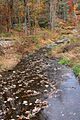
Sugar Hollow Creek looking downstream from State Route 3003
|
|
| Physical characteristics | |
| Main source | between Doll Mountain and Forkston Mountain in Mehoopany Township, Wyoming County, Pennsylvania between 1,380 and 1,400 feet (421 and 427 m) |
| River mouth | Bowman Creek in Eaton Township, Wyoming County, Pennsylvania 636 ft (194 m) 41°30′25″N 75°59′07″W / 41.50693°N 75.98516°W |
| Length | 4.7 mi (7.6 km) |
| Basin features | |
| Progression | Bowman Creek → Susquehanna River → Chesapeake Bay |
| Basin size | 7.07 sq mi (18.3 km2) |
| Tributaries |
|
Sugar Hollow Creek is a small stream in Wyoming County, Pennsylvania. It flows into Bowman Creek. The creek is about 4.7 miles (7.6 km) long. It runs through Mehoopany Township and Eaton Township. The area of land that drains into the creek is about 7.07 square miles (18.3 km2). Sugar Hollow Creek is known for its clean, cold water. It is a great place for fish like wild trout.
Contents
Where Does Sugar Hollow Creek Flow?

Sugar Hollow Creek starts between Doll Mountain and Forkston Mountain. These mountains are in Mehoopany Township. The creek first flows towards the east-northeast. Then it turns to the east-southeast. It then enters Eaton Township.
After a short distance, the creek turns east-northeast again. It then turns southeast. It picks up water from a small stream joining from its right side. As its valley gets narrower, it flows east. It then gets water from another small stream joining from its left side. The creek continues flowing east-southeast for over a mile. Finally, it meets Bowman Creek. Sugar Hollow Creek joins Bowman Creek about 2.62 miles (4.22 km) before Bowman Creek ends.
Water Quality of the Creek
Sugar Hollow Creek has very clean water. It is not listed as a polluted water body. The water has a good amount of alkalinity. This means it can naturally balance out acids. The alkalinity level is about 30 milligrams per liter. This helps keep the water healthy for plants and animals.
Land and Rocks Around the Creek
The land around the mouth of Sugar Hollow Creek is about 636 feet (194 meters) above sea level. Where the creek begins, the land is much higher. It is between 1,380 and 1,400 feet (421 and 427 meters) above sea level. The creek flows through a special valley called Sugar Hollow.
Near the mouth of the creek, the ground is mostly made of Outwash. This is sand and gravel left behind by glaciers. There is also a thin strip of alluvium right along the creek. Alluvium is soil and sediment carried by water. A bit further upstream, you can find Till. Till is another type of soil left by glaciers.
During the Ice Age, melting ice from Sugar Hollow Creek's valley helped create a large delta in Bowman Creek's valley. A delta is a landform that forms at the mouth of a river. This delta has since been split apart by the creek's flow. There are also two "deeply notched" low points at the creek's source. Near the mouth of the valley, there is an old, partly fixed-up pit.
Creek's Drainage Area
The area of land that drains water into Sugar Hollow Creek is called its watershed. This watershed covers about 7.07 square miles (18.3 km2). The mouth of the creek is shown on the United States Geological Survey map called Tunkhannock. However, the source of the creek is on the Meshoppen map.
Sugar Hollow Creek is one of the main streams that flow into Bowman Creek. The entire length of Sugar Hollow Creek flows through private land. About 80 percent of this land is open for people to visit. The other 20 percent is closed.
History of Sugar Hollow Creek

Sugar Hollow Creek was officially added to the Geographic Names Information System on August 2, 1979. This system keeps track of names for places.
In the 1800s, a gristmill used water from Sugar Hollow Creek. A gristmill grinds grain into flour. The water was brought to the mill through a long, wooden pipe.
Several bridges cross Sugar Hollow Creek. A concrete bridge carrying State Route 3003 was built in 1928. It is about 29.9 feet (9.1 meters) long. Another bridge on the same road was built in 1990. This one is about 42.0 feet (12.8 meters) long. A third bridge, also on State Route 3003, was built in 2007. It is about 76.1 feet (23.2 meters) long.
In 2006, a group called the Northern Tier Regional Planning and Development Commission received money. They got a $200,000 grant. This money was used to remove woody debris from along Sugar Hollow Creek. This helps keep the creek healthy and flowing well.
Wildlife and Fish in the Creek
Sugar Hollow Creek is a special place for fish. Wild trout naturally reproduce in the creek. They live there from the very beginning of the creek all the way to its mouth. The area around the creek is known as a High-Quality Coldwater Fishery. This means the water is cold and clean enough for fish that need those conditions. It is also a Migratory Fishery. This means fish that travel to different places use the creek.
The Pennsylvania Fish and Boat Commission has given the entire creek a special title. It is called Class A Wild Trout Waters for rainbow trout. This means it's an excellent place for wild trout. The Commission does not add hatchery-raised trout to the creek. This is done to protect the natural populations of trout already living there.
Images for kids
-
Sugar Hollow Creek looking downstream from State Route 3003
