Cider Run (Bowman Creek tributary) facts for kids
Quick facts for kids Cider Run |
|
|---|---|

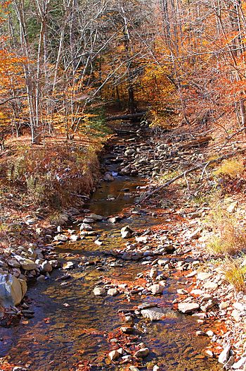
Cider Run looking upstream in its lower reaches
|
|
| Physical characteristics | |
| Main source | valley to the west of The Stack in Forkston Township, Wyoming County, Pennsylvania between 1,940 and 1,960 feet (591 and 597 m) |
| River mouth | Bowman Creek near Mountain Springs in Noxen Township, Wyoming County, Pennsylvania 1,362 ft (415 m) 41°23′03″N 76°08′38″W / 41.38416°N 76.14394°W |
| Length | 2.5 mi (4.0 km) |
| Basin features | |
| Progression | Bowman Creek → Susquehanna River → Chesapeake Bay |
| Basin size | 3.77 sq mi (9.8 km2) |
| Tributaries |
|
Cider Run is a small stream, also called a tributary, that flows into Bowman Creek in Wyoming County, Pennsylvania. It's about 2.5 miles (4.0 km) long and winds through Forkston Township and Noxen Township. The area of land that drains into Cider Run, called its watershed, covers about 3.77 square miles (9.8 km2). This stream is considered very clean and healthy. Its waters are so clean they're called 'Exceptional Value,' and it's a special place for fish that travel, known as a 'Migratory Fishery.' It's also a 'Wilderness Trout Stream,' meaning it's a natural home for trout.
Contents
Where Does Cider Run Flow?
Cider Run starts in a valley west of a place called The Stack. This is in Forkston Township, close to the border of Luzerne County. It flows northeast through the valley for a short distance. Then, it turns north-northeast.
After flowing a bit further, the stream enters Noxen Township. It then turns east-northeast and gets water from a smaller, unnamed stream joining it from the left. Cider Run continues flowing around the northern side of The Stack. It then turns southeast and flows south along the eastern edge of The Stack. Finally, it turns southeast again. A short way downstream, it joins Bowman Creek.
Cider Run meets Bowman Creek about 19.74 miles (31.77 km) before Bowman Creek reaches its own end.
Smaller Streams Joining Cider Run
Cider Run doesn't have any named smaller streams joining it. However, it does have one unnamed tributary. This smaller stream is about 1.4 miles (2.3 km) long and begins in a wetland area.
How Clean is the Water?
Cider Run is known for its clean water. It is not listed as a polluted or "impaired" water body. This means the water quality is very good.
Land and Rocks Around the Stream
The land around the mouth of Cider Run is about 1,362 feet (415 m) above sea level. Where the stream begins, its source, the land is higher, between 1,940 and 1,960 feet (591 and 597 m) above sea level.
The ground near Cider Run is mostly made of alluvium. This is a type of soil and rock left behind by flowing water. In the stream's upper parts, you'll find a different kind of soil called till, specifically Wisconsinan Till. This till was left by glaciers. Underneath some parts of the till, there are clays from old glacial lakes. Higher up in the valley, the main bedrock is made of sandstone and shale.
Cider Run flows through a narrow valley, or glen, which has an interesting rock face in one spot.
The Area That Drains Into Cider Run
The watershed of Cider Run covers an area of about 3.77 square miles (9.8 km2). This entire area is located within the Dutch Mountain quadrangle, which is a map section used by the United States Geological Survey. The mouth of the stream is close to a place called Mountain Springs.
Cider Run is a small stream that is quite hidden away. People have described it as a "trout trickle" because it's a small stream where trout live. It's also hard to get to, as there are no roads that go directly to it.
History and Fun Activities
Cider Run was officially added to the Geographic Names Information System on August 2, 1979. This system keeps track of names and locations of places in the United States.
The stream is located inside Pennsylvania State Game Lands Number 57. This is a large area of land managed for wildlife and outdoor activities. The High Knob Trail, a hiking path, passes close enough to see the glen where Cider Run flows.
Animals and Plants
The area that drains into Cider Run is special. It's called "Exceptional Value waters" because of its very high water quality. It's also a "Migratory Fishery," meaning it's an important place for fish that travel.
Wild trout naturally live and reproduce in Cider Run, from where it starts all the way to where it ends. The stream is also known as a "Wilderness Trout Stream," which means it's a natural home for wild brook trout. Cider Run is one of only two Wilderness Trout Streams in Wyoming County. The other one is Sorber Run.
Cider Run has a good number of wild trout. In 2002, a study found that the total weight of trout living there was about 17.55 kilograms per hectare (15.66 lb/acre).
 | Delilah Pierce |
 | Gordon Parks |
 | Augusta Savage |
 | Charles Ethan Porter |


