Sorber Run facts for kids
Quick facts for kids Sorber Run |
|
|---|---|

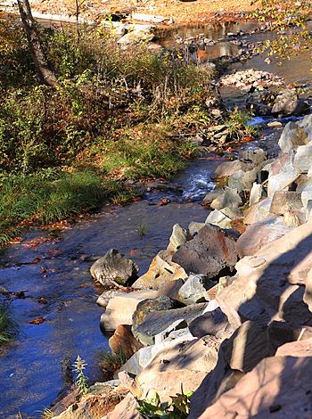
Sorber Run looking downstream near its mouth
|
|
| Physical characteristics | |
| Main source | valley on a mountain in Lake Township, Luzerne County, Pennsylvania between 1,940 and 1,960 feet (591 and 597 m) |
| River mouth | Bowman Creek in Noxen Township, Wyoming County, Pennsylvania 1,142 ft (348 m) 41°24′34″N 76°05′37″W / 41.40958°N 76.09369°W |
| Length | 3.1 mi (5.0 km) |
| Basin features | |
| Progression | Bowman Creek → Susquehanna River → Chesapeake Bay |
| Basin size | 2.08 sq mi (5.4 km2) |
Sorber Run is a small stream, also called a tributary, that flows into Bowman Creek. It's located in Pennsylvania, passing through parts of Luzerne County and Wyoming County. This stream is about 3.1 miles (5.0 km) long.
The area of land that drains into Sorber Run, called its watershed, covers about 2.08 square miles (5.4 km2). This watershed is known for having very clean water. It is also a special place for fish that travel, like trout. Sorber Run is one of only two "Wilderness Trout Streams" in Wyoming County. This means it's a great place for wild trout to live and grow.
Contents
Where Sorber Run Flows
Sorber Run starts high up in a valley on a mountain in Lake Township, Luzerne County. It flows mostly east-northeast at first. Then, it turns northeast for a short distance.
The stream then heads north, moving through a valley. This valley is located to the west of Sorber Mountain. After a while, Sorber Run leaves Luzerne County. It then enters Noxen Township in Wyoming County.
In Wyoming County, the stream turns north-northwest. It flows this way for some distance before turning north again. Finally, it turns north-northwest one last time. It leaves its valley and flows north to meet Bowman Creek. Sorber Run joins Bowman Creek about 16.25 miles (26.15 km) upstream from where Bowman Creek ends.
Land and Water Around the Stream
The spot where Sorber Run meets Bowman Creek is about 1,142 feet (348 meters) above sea level. Where the stream begins, its source, the elevation is much higher. It's between 1,940 and 1,960 feet (591 and 597 meters) above sea level.
Close to Sorber Run, the ground is mostly made of alluvium. This is a type of soil left behind by flowing water. A bit further from the stream, the ground changes. It becomes a type of rock and soil mixture called till. This specific till was left by glaciers during the Ice Age.
Sorber Run is known as a "High-gradient Clearwater Creek." This means it flows downhill quite steeply. It also has very clear water.
The Sorber Run Watershed
The watershed of Sorber Run covers an area of about 2.08 square miles (5.4 km2). This entire area is located within the United States Geological Survey map section called Noxen.
Most of Sorber Run flows through a protected area. This area is known as Pennsylvania State Game Lands Number 57.
History of Sorber Run
Sorber Run was officially added to the Geographic Names Information System on August 2, 1979. This system keeps track of names for places like rivers and mountains.
In 2005, the Pennsylvania Fish and Boat Commission looked at Sorber Run. They considered adding it to their list of "Class A Wild Trout Waters." This special list is for streams where wild trout are doing very well.
Wildlife in Sorber Run
The area around Sorber Run is very important for wildlife. It's called "Exceptional Value waters." This means the water quality is excellent. It's also a "Migratory Fishery," which means fish travel through it.
Wild trout naturally live and reproduce in Sorber Run. They can be found from the very beginning of the stream all the way to its end. The Pennsylvania Fish and Boat Commission has given Sorber Run a special title. It's a "Wilderness Trout Stream" for wild brook trout. This makes it one of only two such streams in Wyoming County. The other one is Cider Run.
When scientists studied Sorber Run in 2002, they found many trout. The amount of trout, called their biomass, was more than 45 kilograms per hectare (40 pounds per acre). This showed that the stream is a healthy home for these fish. Sorber Run is also listed on the Wyoming County Natural Areas Inventory. This list highlights important natural places in the county.
 | Selma Burke |
 | Pauline Powell Burns |
 | Frederick J. Brown |
 | Robert Blackburn |


