
Roaring Run (Bowman Creek tributary) facts for kids
Quick facts for kids Roaring Run |
|
|---|---|

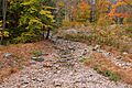
Roaring Run looking upstream in its lower reaches from Pennsylvania Route 29
|
|
| Other name(s) | Roaring Creek |
| Physical characteristics | |
| Main source | deep valley on Forkston Mountain in Forkston Township, Wyoming County, Pennsylvania between 1,960 and 1,980 feet (597 and 604 m) |
| River mouth | Bowman Creek in Monroe Township, Wyoming County, Pennsylvania 791 ft (241 m) 41°27′27″N 76°01′42″W / 41.45742°N 76.02825°W |
| Length | 4.9 mi (7.9 km) |
| Basin features | |
| Progression | Bowman Creek → Susquehanna River → Chesapeake Bay |
| Basin size | 11.4 sq mi (30 km2) |
| Tributaries |
|
Roaring Run (also known as Roaring Creek) is a stream in Wyoming County, Pennsylvania. It flows into Bowman Creek. Roaring Run is about 4.9 miles (7.9 km) long. It travels through Forkston Township, Noxen Township, and Monroe Township. Two smaller streams, Newton Run and South Branch Roaring Run, flow into it.
The area of land that drains into Roaring Run is 11.4 square miles (30 km2). This stream is special because it is a High-Quality Coldwater Fishery and a Migratory Fishery. This means it has very clean, cold water that is good for fish. It is also a Class A Wild Trout Waters, which is a top rating for streams where wild trout live and reproduce naturally.
Contents
The Journey of Roaring Run

Roaring Run starts high up in a deep valley on Forkston Mountain. This is in Forkston Township. It flows south through its valley. After a while, it turns to flow south-southeast. The stream continues in this direction for over a mile. Then, a stream called South Branch Roaring Run joins it from the right side.
After this, the valley around Roaring Run gets a bit wider. The stream turns southeast and enters Noxen Township. Here, it flows east-northeast for a short distance. Then it turns east-southeast. Another stream, Newton Run, joins it from the left side. The creek then leaves its valley. It turns southeast for a short distance before turning south. A bit further downstream, it flows under Pennsylvania Route 29. Soon after, it meets and joins Bowman Creek.
Roaring Run joins Bowman Creek about 8.49 miles (13.66 km) before Bowman Creek reaches its own end.
Streams Joining Roaring Run
Roaring Run has two important streams that flow into it. These are Newton Run and South Branch Roaring Run. Newton Run joins Roaring Run about 0.42 miles (0.68 km) upstream from its mouth. The area of land that drains into Newton Run is 2.55 square miles (6.6 km2). South Branch Roaring Run joins Roaring Run about 2.34 miles (3.77 km) upstream from its mouth. The area of land that drains into South Branch Roaring Run is 3.31 square miles (8.6 km2).
Water Quality of Roaring Run
The water in Roaring Run is measured for its alkalinity. Alkalinity tells us how well the water can handle pollution without changing its pH level too much. Upstream from where South Branch Roaring Run joins, the alkalinity of Roaring Run is 10 milligrams per liter (0.0100 oz/cu ft). After South Branch Roaring Run adds its water, the alkalinity of Roaring Run increases slightly to 11 milligrams per liter (0.011 oz/cu ft).
Land and Rocks Around the Stream
The land around the mouth of Roaring Run is about 791 feet (241 m) above sea level. Where the stream begins, its source, the elevation is higher. It is between 1,960 and 1,980 feet (597 and 604 m) above sea level.
Near its lower parts, Roaring Run flows over a type of ground called alluvium. This is made of sand, silt, and clay deposited by moving water. Next to this area are places with alluvial terraces and alluvial fans. These are also formed by water. Further upstream, the alluvium continues. It is next to areas with alluvial fan, Wisconsinan Ice-Contact Stratified Drift, and Wisconsinan Till. These are all types of soil and rock left behind by glaciers. There is also bedrock here, which is made of sandstone and shale. Near the stream's beginning, the ground is mostly Wisconsinan Till and bedrock.
Over a very long time, the sediment (dirt and small rocks) from Roaring Run has pushed Bowman Creek's path. This has made Bowman Creek cut into the hard bedrock. This cutting has formed a waterfall called Evans Falls. It is about 0.1 miles (0.16 km) downstream from where Roaring Run joins Bowman Creek.
The Roaring Run Area
The entire area of land that drains water into Roaring Run is called its watershed. This watershed covers an area of 11.4 square miles (30 km2). Roaring Run is completely within the United States Geological Survey quadrangle map area called Noxen. Part of the stream is about 6 miles (9.7 km) from the village of Forkston.
All of Roaring Run flows through private land. This means people cannot access it without permission. The stream is located near the community of Noxen. Roaring Run is one of the main streams that flows into Bowman Creek.
History of Roaring Run
Roaring Run was officially added to the Geographic Names Information System on August 2, 1979. It is also known by the name Roaring Creek.
In 1880, a portable steam mill was being set up along Roaring Run. This shows that the area was used for logging or other industries back then.
A concrete bridge was built in 1939 to carry Pennsylvania Route 29 over Roaring Run. This bridge is 49.9 feet (15.2 m) long and is in Monroe Township.
The path of Roaring Run was damaged during a flood on January 25, 2010. However, the Wyoming County Conservation District received a grant of $125,000. This money helped to repair the stream's path and four other stream paths in the area.
Wildlife in Roaring Run
The watershed of Roaring Run is special for its fish. It is called a High-Quality Coldwater Fishery and a Migratory Fishery. This means it is a great place for fish that need cold, clean water. Wild trout naturally reproduce in the stream. They live from its very beginning all the way to where it joins Bowman Creek.
From its source down to where South Branch Roaring Run joins, which is about 2.6 miles (4.2 km), Roaring Run is a Class A Wild Trout Waters for brook trout. This is a very high rating for trout streams. From South Branch Roaring Run down to its mouth, about 2.4 miles (3.9 km), Roaring Run is a Class A Wild Trout Waters for both brook trout and rainbow trout. Roaring Run is the only place in Pennsylvania where both wild brook trout and rainbow trout live and reproduce together in a Class A fishery.
Images for kids
-
Roaring Run looking upstream in its lower reaches from Pennsylvania Route 29
-
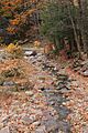
Roaring Run looking downstream in its lower reaches from Pennsylvania Route 29
