Newton Run facts for kids
Quick facts for kids Newton Run |
|
|---|---|

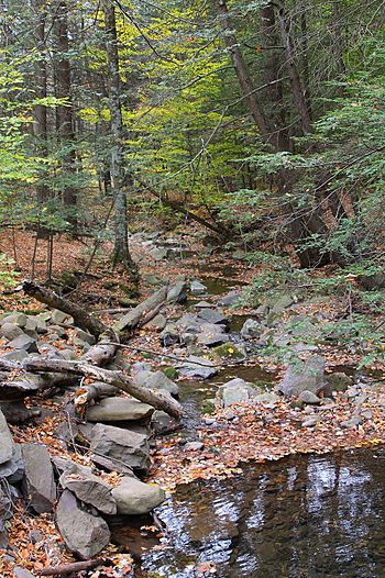
Newton Run looking downstream from Root Hollow Lane
|
|
| Physical characteristics | |
| Main source | valley on the side of a hill in Eaton Township, Wyoming County, Pennsylvania between 1,980 and 2,000 feet (604 and 610 m) |
| River mouth | Roaring Run in Monroe Township, Wyoming County, Pennsylvania 856 ft (261 m) 41°27′42″N 76°01′53″W / 41.46160°N 76.03152°W |
| Length | 2.7 mi (4.3 km) |
| Basin features | |
| Progression | Roaring Run → Bowman Creek → Susquehanna River → Chesapeake Bay |
| Basin size | 2.55 sq mi (6.6 km2) |
Newton Run is a small stream, also called a tributary, in Wyoming County, Pennsylvania. It flows into another stream called Roaring Run. This stream is about 2.7 miles (4.3 km) long. It flows through two areas: Eaton Township and Monroe Township. The land area that drains water into Newton Run, called its watershed, is about 2.55 square miles (6.6 km2). Good news! This stream is considered healthy and clean. The ground around the stream has different types of soil and rock. You can find things like alluvium (river deposits), glacial Till from the Wisconsinan ice age, and solid bedrock.
Contents
Where Newton Run Flows
Newton Run starts in a valley, which is a low area between hills, in Eaton Township. It flows generally south, changing direction a few times. The stream then enters Monroe Township. After flowing a bit further, it leaves its valley. It then runs next to Roaring Run for a short distance. Finally, Newton Run joins Roaring Run.
Newton Run meets Roaring Run about 0.42 miles (0.68 km) before Roaring Run reaches its own end.
Stream Health and Water Quality
Newton Run is a very healthy stream. It is not listed as an "impaired waterbody." This means its water quality is good and it supports healthy aquatic life.
Land and Rocks Around the Stream
The land around the end of Newton Run is about 856 feet (261 m) above sea level. Where the stream begins, its source, the land is much higher. It is between 1,980 and 2,000 feet (604 and 610 m) above sea level.
The ground along the lower parts of Newton Run has alluvium. This is soil and rock left behind by flowing water. Further away from the stream, you can find Wisconsinan Till. This is a mix of clay, sand, and rocks left by glaciers from the last ice age. There is also an alluvial fan, which is a fan-shaped deposit of sediment. In the upper parts of the stream, the ground is mostly Wisconsinan Till. The sides of the valley have solid bedrock made of sandstone and shale.
The Newton Run Watershed
The watershed of Newton Run covers an area of 2.55 square miles (6.6 km2). A watershed is all the land where water drains into a particular stream or river. This stream is entirely within the Noxen area, as mapped by the United States Geological Survey.
In 2012, a company called Chief Gathering LLC received permission to build a natural gas pipeline. This pipeline, which is 24-inch (61 cm) wide, crosses Newton Run. They also built special temporary bridges made of timber mats over the stream and one of its smaller branches.
A Look at History
Newton Run was officially added to the Geographic Names Information System on August 2, 1979. This system helps keep track of names and locations for places in the United States. Its special ID number in the system is 1199222.
In the 2000s, there was a plan to build a wind farm in Wyoming County. This project was proposed by a company called BP Alternative Energy. However, people were worried about how water runoff from the wind farm might affect local streams. Newton Run was one of the streams in the area that could have been impacted.
Wildlife in Newton Run
Newton Run is a great place for trout! Wild trout naturally live and reproduce in this stream. You can find them from where the stream starts all the way down to where it joins Roaring Run.
 | William M. Jackson |
 | Juan E. Gilbert |
 | Neil deGrasse Tyson |


