
Stone Run (Bowman Creek tributary) facts for kids
Quick facts for kids Stone Run |
|
|---|---|

Mouth of Stone Run at State Route 3002
|
|
| Other name(s) | Slife Run |
| Physical characteristics | |
| Main source | plateau in Noxen Township, Wyoming County, Pennsylvania between 2,200 and 2,220 feet (671 and 677 m) |
| River mouth | Bowman Creek in Noxen Township, Wyoming County, Pennsylvania 1,109 ft (338 m) ACoordinates: Unknown argument format |
| Length | 2.2 mi (3.5 km) |
| Basin features | |
| Progression | Bowman Creek → Susquehanna River → Chesapeake Bay |
| Basin size | 2.43 sq mi (6.3 km2) |
Stone Run (also known as Slife Run) is a small stream in Wyoming County, Pennsylvania. It flows into Bowman Creek. This stream is about 2.2 miles (3.5 km) long. It runs through Noxen Township.
The area of land that drains into Stone Run is 2.43 square miles (6.3 km2). This stream is known for its clean water. It is a special place where wild trout live. The area around it is also good for fish that travel, like salmon.
Contents
Where Stone Run Flows

Stone Run starts high up on a flat area called a plateau in Noxen Township. It flows mostly south-southeast at first. Then, it goes into a valley near Stone Mountain. After that, it turns and flows east-northeast for a while.
The stream changes direction a few more times. It flows southeast, then east-northeast, and finally east-southeast. After traveling a bit more, it turns east-northeast for a short distance. Then, it meets Bowman Creek. Stone Run joins Bowman Creek about 15.56 miles (25.04 km) before Bowman Creek reaches its own end.
Water Quality
Stone Run has very clean water. It is not listed as a polluted stream. The water has a small amount of alkalinity, which helps keep the water stable for fish.
Land and Rocks Around the Stream
The land around the end of Stone Run is about 1,109 feet (338 m) above sea level. Where the stream begins, it is much higher, between 2,200 and 2,220 feet (671 and 677 m) above sea level.
The ground near the lower part of Stone Run is mostly made of alluvium. This is soil and rock left by flowing water. Closer to the stream's start, the ground has different types of Till. These are rocks and dirt left behind by glaciers from the Ice Age.
Stone Run's Watershed
The watershed of Stone Run covers an area of 2.43 square miles (6.3 km2). A watershed is all the land where water drains into a specific stream or river. This entire stream is located within the Noxen area map made by the United States Geological Survey.
Most of Stone Run, about 77 percent, flows through public land. This means people can visit and enjoy these parts of the stream. The other 23 percent is on private land, which is not open to the public.
History of Stone Run
Stone Run was officially named and added to a national list of geographic names on August 2, 1979. It is also known by another name, Slife Run. This name appeared on a map from 1946.
Years ago, in the 2000s, there was a plan to build a wind farm in Wyoming County. People were worried about how water runoff from the wind farm might affect streams like Stone Run.
Animals in Stone Run
The area around Stone Run is a special place for fish. It is called a High-Quality Coldwater Fishery. This means its cold, clean water is perfect for fish that need cool temperatures. It is also a Migratory Fishery, which means fish that travel can use it.
Wild trout naturally live and reproduce in Stone Run. They are found from the very beginning of the stream all the way to where it joins Bowman Creek. The Pennsylvania Fish and Boat Commission has given Stone Run a special rating. It is called Class A Wild Trout Waters for brook trout. This means it is one of the best places for these fish.
In the 1930s, small brook trout called fingerlings were added to Stone Run.
Images for kids
-
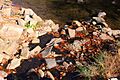
Mouth of Stone Run at State Route 3002
See also
 In Spanish: Río Pedregoso (Bowman Creek) para niños
