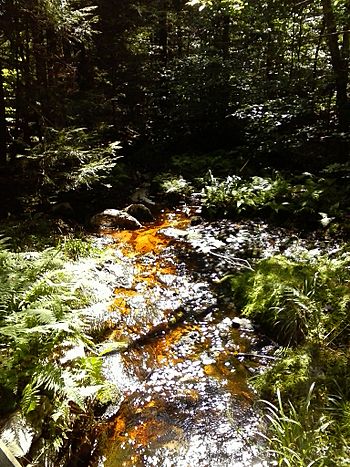
South Branch Bowman Creek facts for kids
Quick facts for kids South Branch Bowman Creek |
|
|---|---|

South Branch Bowman Creek in Ricketts Glen State Park
|
|
| Physical characteristics | |
| Main source | wetland in Fairmount Township, Luzerne County, Pennsylvania between 2,160 and 2,180 feet (658 and 664 m) |
| River mouth | Bowman Creek at Mountain Springs in Ross Township, Luzerne County, Pennsylvania 1,837 ft (560 m) 41°20′26″N 76°13′14″W / 41.34056°N 76.22062°W |
| Length | 3.0 mi (4.8 km) |
| Basin features | |
| Progression | Bowman Creek → Susquehanna River → Chesapeake Bay |
| Basin size | 3.92 sq mi (10.2 km2) |
| Tributaries |
|
South Branch Bowman Creek, sometimes called Cherry Run, is a small stream in Luzerne County, Pennsylvania. It flows into a larger stream called Bowman Creek. This creek is about 3 miles (4.8 km) long. It runs through Fairmount Township and Ross Township.
The area of land that drains into the creek is about 3.92 square miles (10.2 km2). Most of this creek flows through the beautiful Ricketts Glen State Park. The ground around the creek has different types of soil and rocks. These include areas shaped by ancient glaciers and wetlands. South Branch Bowman Creek has one main smaller stream that flows into it, also called Cherry Run. This creek's water is very clean and cold. It is a great place for fish that travel to lay eggs.
Contents
Where the Creek Flows
South Branch Bowman Creek starts in a wet, marshy area in Fairmount Township. It first flows north for a short distance. Then, it turns east for a few tenths of a mile. After that, the creek turns north again for a bit. It then heads east-northeast.
In this part of its journey, it meets Cherry Run. Cherry Run is the only named smaller stream that flows into South Branch Bowman Creek. It joins from the left side. The creek then turns east-southeast before turning east-northeast again. It flows through a lake called Mount Spring Lake. From the eastern end of the lake, the creek continues east-northeast. After a short distance, it joins Bowman Creek.
South Branch Bowman Creek meets Bowman Creek about 26.13 miles (42.05 km) upstream from Bowman Creek's end.
Smaller Streams
South Branch Bowman Creek has one named smaller stream, which is called Cherry Run. Cherry Run joins South Branch Bowman Creek about 1.25 miles (2.01 km) upstream from its end. This meeting point is near Mountain Springs. The area of land that drains into Cherry Run is about 1.65 square miles (4.27 km2).
Land and Rocks Around the Creek
The land around the end of South Branch Bowman Creek is about 1837 feet (560 m) above sea level. The creek's starting point is even higher. It is between 2160 and 2180 feet (658 and 664 m) above sea level.
The ground in the lower part of the creek's valley has different types of soil and rocks. These include alluvium (soil left by flowing water) and alluvial fan (fan-shaped deposits). There are also rocks and soil left by glaciers. Some areas have large rocks called boulders. These boulders often contain quartz, sandstone, or conglomerate.
Further upstream, you can find more rocks and soil left by glaciers. The sides of the valley are made of bedrock. This bedrock is mostly sandstone and shale. In the upper parts of the creek, the ground mainly has glacial deposits and wetlands.
Long ago, before glaciers, water from areas like Lake Leigh and part of Lake Jean used to flow into South Branch Bowman Creek. But glaciers changed the land. Now, this water flows into Kitchen Creek instead. There was also a glacial lake in the valley of South Branch Bowman Creek in the past.
Water and Its Surroundings
The entire area of land that drains water into South Branch Bowman Creek is about 3.92 square miles (10.2 km2). The end of the creek is in an area mapped by the United States Geological Survey called Sweet Valley. However, its source is in the Red Rock map area. The creek ends at a place called Mountain Springs.
Most of South Branch Bowman Creek flows through Ricketts Glen State Park. But the lower parts, including Mount Springs Lake, are on land owned by the Pennsylvania Fish and Boat Commission. You can go hunting along most of the creek within Ricketts Glen State Park. However, hunting is not allowed near the very start of the creek.
In the 1980s, scientists found that the water in South Branch Bowman Creek had high levels of acidity.
History and Fun Activities
South Branch Bowman Creek was officially added to the Geographic Names Information System on August 2, 1979. Its special ID number there is 1188015. The creek is also known as Cherry Run. This other name appeared on a 1953 map by the United States Geological Survey. However, in 1969, it was found that this name was not correct for the main creek.
A fun hiking trail called the Cherry Run Trail crosses South Branch Bowman Creek. This trail is located in Ricketts Glen State Park. Another hiking trail, the Mountain Springs Trail, is also close to the creek.
Creek Life
The area that drains into South Branch Bowman Creek is special. It is known as a High-Quality Coldwater Fishery. This means its water is very clean and cold, which is great for certain fish. It is also a Migratory Fishery. This means fish that travel long distances to lay their eggs use this creek.
Wild trout naturally live and reproduce in the creek. They can be found from the very start of the creek all the way down to where it joins Bowman Creek.
 | Kyle Baker |
 | Joseph Yoakum |
 | Laura Wheeler Waring |
 | Henry Ossawa Tanner |

