
Laurel Run, Pennsylvania facts for kids
Quick facts for kids
Laurel Run, Pennsylvania
|
|
|---|---|
|
Borough
|
|

A view of Wilkes-Barre from Giants Despair Mountain (in Laurel Run)
|
|

Location of Laurel Run in Luzerne County, Pennsylvania
|
|

Laurel Run, Pennsylvania
Location in Pennsylvania

Laurel Run, Pennsylvania
Location in the United States
|
|
| Country | United States |
| State | Pennsylvania |
| County | Luzerne |
| Incorporated | 1881 |
| Government | |
| • Type | Borough Council |
| Area | |
| • Total | 5.10 sq mi (13.21 km2) |
| • Land | 5.10 sq mi (13.21 km2) |
| • Water | 0.00 sq mi (0.00 km2) |
| Population
(2020)
|
|
| • Total | 558 |
| • Density | 109.39/sq mi (42.23/km2) |
| Time zone | UTC-5 (Eastern (EST)) |
| • Summer (DST) | UTC-4 (EDT) |
| Area code(s) | 570 |
| FIPS code | 42-41848 |
| Website | {{}} |
Laurel Run is a small town, called a borough, located in Luzerne County, Pennsylvania, United States. In 2020, about 560 people lived there. It is known for its beautiful mountainous forests and a special car race.
Contents
A Look Back: Laurel Run's History
Laurel Run became an official borough in 1881. This means it was recognized as its own town with its own local government.
Giants Despair Hillclimb Race
The borough is home to one of Pennsylvania's oldest continuous motorsport events. Since 1906, the annual Giants Despair Hillclimb has challenged drivers. They race uphill on a one-mile stretch of East Northampton Street. It's a thrilling event for car enthusiasts.
The Mine Fire and Relocation
In 1915, a mine fire started in the borough's Red Ash mine. Workers tried to put out the fire by digging out the mine. Even though it was declared out in 1973, the fire is still burning deep underground.
Because of the mine fire, many homes and businesses had to be moved. About 166 homes, two grocery stores, a church, a school, and a lumberyard were relocated. This was done through a special program to keep people safe.
Exploring Laurel Run: Geography
Laurel Run is located at 41°13′2″N 75°50′29″W / 41.21722°N 75.84139°W. The borough covers about 13.4 square kilometers (5.1 square miles) of land. There is no water area within its borders.
Nature and Landscape
The borough is not very crowded. Most of Laurel Run is covered by mountains and forests. It's a great place for nature lovers.
A stream named Laurel Run flows through much of the borough. This stream is a tributary, which means it flows into a larger stream called Mill Creek.
Who Lives Here: Demographics
| Historical population | |||
|---|---|---|---|
| Census | Pop. | %± | |
| 1890 | 696 | — | |
| 1900 | 696 | 0.0% | |
| 1910 | 790 | 13.5% | |
| 1920 | 774 | −2.0% | |
| 1930 | 944 | 22.0% | |
| 1940 | 1,057 | 12.0% | |
| 1950 | 858 | −18.8% | |
| 1960 | 855 | −0.3% | |
| 1970 | 327 | −61.8% | |
| 1980 | 725 | 121.7% | |
| 1990 | 708 | −2.3% | |
| 2000 | 723 | 2.1% | |
| 2010 | 500 | −30.8% | |
| 2020 | 560 | 12.0% | |
| 2021 (est.) | 563 | 12.6% | |
| Sources: | |||
In 2000, there were 723 people living in Laurel Run. These people lived in 277 households, with 188 of them being families.
Population Changes Over Time
The population of Laurel Run has changed quite a bit over the years. In 1940, it reached its highest point with 1,057 people. By 2010, the population had dropped to 500. However, it grew slightly to 560 by 2020.
Age and Community
In 2000, about 19.4% of the residents were under 18 years old. About 11.8% were 65 years or older. The average age of people living in Laurel Run was 40 years old.
Learning in Laurel Run: Education
Students in Laurel Run attend schools within the Wilkes-Barre Area School District.
Gallery
-
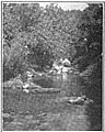
Laurel Run, a stream, in the late 1800s or early 1900s.
-
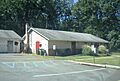
The borough's municipal building in September 2023.


See also
 In Spanish: Laurel Run (Pensilvania) para niños
