
Wapwallopen, Pennsylvania facts for kids
Quick facts for kids
Wapwallopen, Pennsylvania
|
|
|---|---|

View of Wapwallopen
|
|

Wapwallopen, Pennsylvania
Location in Pennsylvania

Wapwallopen, Pennsylvania
Location in the United States
|
|
| Country | United States |
| State | Pennsylvania |
| County | Luzerne |
| Township | Conyngham |
| Elevation | 541 ft (165 m) |
| Time zone | Eastern (EST) |
| • Summer (DST) | EDT |
| ZIP code |
18660
|
| Area code(s) | 570 |
| GNIS feature ID | 1193606 |
Wapwallopen is a small place in Luzerne County, Pennsylvania, United States. It's known as an unincorporated community. This means it's a group of homes and businesses that isn't officially a town or city with its own local government. Instead, it's part of a larger area called Conyngham Township.
Wapwallopen is located in a beautiful part of Pennsylvania. It sits near where the Big Wapwallopen Creek flows into the big Susquehanna River.
The Story Behind the Name
The name Wapwallopen has a cool history! It comes from the Lenni Lenape people. They were Native Americans who lived in this area a long time ago. They had a settlement here.
The name comes from their Unami language. The word òphalahpink means 'place of white wild hemp'. So, the name tells us that this area once had a lot of white wild hemp plants growing there.
Getting Around Wapwallopen
A main road called Pennsylvania Route 239 goes right through Wapwallopen. This road helps people travel to and from the community. It connects Wapwallopen to other nearby towns and areas.
-
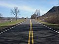
Pennsylvania Route 239 in Wapwallopen

