
Orson, Pennsylvania facts for kids
Quick facts for kids
Orson, Pennsylvania
|
|
|---|---|
.jpg)
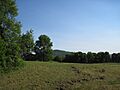
Orson as seen from Crosstown Highway, facing east.
|
|
| Nickname(s):
Hine's Corners (historical), Orson Corners (rarely used)
|
|

Orson, Pennsylvania
Location in Pennsylvania
|
|
| Country | United States |
| State | Pennsylvania |
| U.S. Congressional District | PA-10 |
| School District | Wayne Highlands Region I |
| County | Wayne |
| Magisterial District | 22-3-04 |
| Township | Preston |
| Settled | 1831 or 1840 |
| Founded by | Merritt Hine |
| Named for | Orson C. Chamberlain |
| Elevation | 1,998 ft (609 m) |
| Time zone | UTC-5 (Eastern (EST)) |
| • Summer (DST) | UTC-4 (Eastern Daylight (EDT)) |
| ZIP codes | |
| Area code(s) | 570 |
| GNIS feature ID | 1183050 |
| FIPS code | 42-127-62600-57144 |
| Major Roads | |
| Waterways | Independent Lake, Lackawanna River (East Branch), Lackawaxen River (West Branch), Mud Pond, Orson Pond |
Orson is a small community in Preston Township, Pennsylvania, United States. It is located in the beautiful Poconos region, near many lakes.
Long ago, Orson was an important stop for the New York, Ontario & Western (O&W) Railway. Today, it is mostly known for being where two state roads, PA-670 and PA-370, meet. Orson is also home to Independent Lake Camp (ILC), a popular summer camp.
Contents
What is a Village in Pennsylvania?

You might see signs from the Pennsylvania Department of Transportation (PennDOT) that say "Village of Orson." This can be a bit confusing! In Pennsylvania, a "village" like Orson is not a separate town with its own government. Instead, it is an unincorporated community that is part of a larger township.
This means Orson does not have official borders, and the government does not collect special information about its population. However, local people usually agree on where Orson begins and ends. Many places are named after the village, which helps everyone know what belongs to Orson.
Exploring Orson's Natural Beauty


Orson is surrounded by beautiful natural spots. Some of the most famous include:
- Mount Ararat: A large mountain, sometimes just called "Ararat."
- Independent Lake: A lovely lake that is partly in Orson and partly in Poyntelle, Pennsylvania. It used to be called Independence Pond.
- Mud Pond: Another pond, partly in East Ararat.
- Orson Pond: This pond was made much bigger when the Orson Pond Dam was built. It was once used for harvesting ice.
- Sugarloaf Mountain: A scenic mountain that was once called Sugar Loaf Peak.
Independent Lake is one of the main sources for the East Branch of the Lackawanna River. It gets its water from natural springs at the bottom of the lake. Orson Pond drains into the Lackawanna River.
Roads and How to Get Around Orson
Orson is centered around where Belmont Turnpike and Crosstown Highway meet. This is a very important intersection! Belmont Turnpike and PA-670 both end here.
North of this intersection, you'll find Oxbow Road. This road is not part of PA-670 or Belmont Turnpike.
Local Township Roads
Orson also has several smaller roads that are maintained by the township. These include:
- Blewett Road (T678)
- Clark Road (T579)
- Doyle Road (T686)
- Hines Road (T692)
- Mud Pond Road (T565)
- Paluch Road (T567)
Many of these township roads, like Blewett and Clark, are unpaved. There is also one private, unpaved road called Black Bear Lane.
A Look Back: Orson's History
The community we know as Orson was started by Merritt Hine in 1840. Some records say he was from Connecticut, others from Massachusetts, and some say he founded it in 1831. His father, David Hine, a veteran of the Revolutionary War, later moved to Pennsylvania too.
In its early days, the settlement was called Hine's Corners. It was located around where Clark and Oxbow Roads are today. The name "Hines Corners" is still used for that intersection on maps.
Growing a Community
Hine's Corners grew quickly. People made a living by farming, dairy farming, and harvesting ice from the many lakes. The Hine's Corners United Methodist Congregation started in 1849, and their church was finished in 1876. The Hine's Corners Post Office opened in 1873.
A New Name for the Village
On December 25, 1878, a young boy named Orson C. Chamberlain died. He was a great-grandchild of Merritt Hine. To honor him, the community became known as Orson Corners, which was usually shortened to Orson. The post office was renamed "Orson Post Office" in 1896.
The Railroad Era
When the O&W Railway expanded to Scranton, Pennsylvania, in 1890, it built a train station in Orson. This station was called both "Orson" and "Belmont" on maps. Its construction caused the village to shift slightly south, closer to the new railroad.
The railroad brought a lot of success to Orson. At its busiest, the village had:
- Two creameries (places that make dairy products)
- Two ice houses
- A grain mill
- A sawmill
- Several hotels and stores
These businesses served the many people who came to Orson because of the O&W Railway.
The Rise of Summer Camps

The train station building burned down in 1933 and was never rebuilt. The O&W Railway went out of business in 1957. This marked the end of Orson's time as a major railroad hub. Many businesses closed, but summer camps began to take their place as a key part of Orson's identity.
The first camp was Camp Nehantic, a Jewish girls' camp that moved to Orson in 1925 or 1926. It became very important to the local economy. Over the years, other camps, like Camps Carmelia and Keeyumah, also opened on the western side of Independent Lake.
Meanwhile, Camp Echo Lark started on the eastern side of the lake in 1927. It was originally a Jewish girls' camp but later became coed (for both boys and girls).
In 1981, Camp Westmont opened on the western side of the lake. Then, in 1992, Westmont and New England Experience (another camp) switched locations. New England Experience moved to Orson and changed its name to NE2 at Independent Lake, and then simply "Independent Lake Camp" (ILC).
Today, Independent Lake Camp still operates on the western bank of the lake. It has expanded to include a new area called "Elkview," named after Elk Hill, which can be seen from there.
Interesting Places to See in Orson

- Orson Cemetery: This small family cemetery, once called Hine's Corners Cemetery, is no longer used for burials. It holds the graves of early settlers, including the Hine family and Orson C. Chamberlain. It is on Clark Road.
- Orson Field Airport: A private airstrip that connects to Hines Road.
- Former Orson ME Church: The building that used to be the Orson Methodist Episcopal Church is on Oxbow Road. It is no longer a church.
- Cell Towers: There are three cell towers in Orson. One is owned by the North-Eastern Pennsylvania Telephone Company (NEP), and two are owned by the state of Pennsylvania and the Pennsylvania State Police (PSP).
- PA O&W Trail: This trail, maintained by the Rails-to-Trails Conservancy, runs through Orson. It follows the path of the old O&W Railway.
Hines Corners Plaque
At Hines Corners, there is a plaque honoring David and Merritt Hine, the first settlers. It was placed there in 1925 by their family. The plaque says they founded the community in 1811, but historical records suggest it was more like 1831 or 1840. It is possible that the family story changed a bit over time.
Orson Post Office and ZIP Codes
The Orson Post Office is located in the basement of a home on Belmont Turnpike. While it is technically still open, it stopped providing mail services in 2008.
Orson's official ZIP code is 18449. However, because the post office is not active, most people in Orson now use ZIP codes from nearby towns like Lakewood (18439), Thompson (18465), or Union Dale (18470). This can sometimes be confusing, as those towns are in different counties! Even so, the physical addresses in Orson can still correctly use "Orson, PA 18449."
Learning in Orson: Schools Through Time
Orson has had four public schools in its history. The first two, called "Hine's Corners School," were on Oxbow Road and operated from 1860 to about 1890.
The third and fourth schools, known as "Orson School," were built after the community became Orson. They were located near the Orson ME Church. The last of these schools was open from 1924 to 1956. The building is still standing today and is now a private home.
Modern Education
Today, students in Orson attend schools in the Wayne Highlands School District. The closest school is the Preston Area School in Lakewood, which serves students from kindergarten to 8th grade. For high school, students go to Honesdale High School, which serves the entire district.
Orson's Local Economy
Orson has one business that operates all year round:
- Orson Corners Veterinary Clinic: Located on Crosstown Highway, this clinic mainly helps local dairy farms. The veterinarian, Dr. James Watson, used to have a heliport (a place for helicopters to land) behind the clinic to help him visit farms.
The Orson Country Inn, also known as "the O," was a popular place for locals and visitors to gather. It was an inn with a bar and event space, but it has since closed.
Orson also has one seasonal business:
- Independent Lake Camp (ILC): This summer camp operates every year from late June to late August.
Images for kids
-
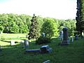
Orson Cemetery.
-
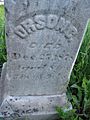
Orson C. Chamberlain's grave.
-
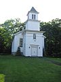
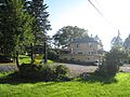
The former Orson UM Church.
-
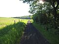
The O&W Trail.
-
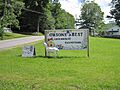
Sign for Orson's Best Garden Center and Farmstand.
-
The Orson Country Inn.
-
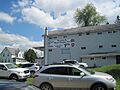
Orson Corners Veterinary Clinic.
-
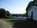
Elk Mountain viewed from the nameless hill above Elkview, with camp buildings in the foreground.
-
Mount Ararat viewed from the nameless hill above Elkview.
-

Sugarloaf Mountain viewed from the nameless hill above Elkview, with camp buildings in the foreground.


Nearby Communities
 |
|
|||
