Mount Ararat (Pennsylvania) facts for kids
Quick facts for kids Mount Ararat |
|
|---|---|
| Ararat Mountain, Ararat Peak, Ararat Summit, Ararat | |

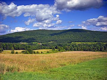
Mount Ararat, as seen from East Ararat on Crosstown Highway between Belmont Turnpike and Pennsylvania Route 171 (PA-171), facing northeast.
|
|
| Highest point | |
| Elevation | 2,638 ft (804 m) |
| Prominence | 816 |
| Geography | |
| Location | Belmont Corners, Pennsylvania Orson, Pennsylvania |
| Parent range | Glaciated Allegheny Plateau (Appalachian Mountains) |
| Topo map | USGS Orson (PA) |
Mount Ararat is a cool mountain found in Pennsylvania, in two small villages called Belmont Corners and Orson. Its very top, or 'summit,' is in Orson. It's the highest spot in all of Wayne County, Pennsylvania! It's also one of the tallest points in eastern Pennsylvania. This mountain is part of a special area called the Glaciated Low Plateaus. This means that glaciers long ago shaped the land here, creating gentle, rolling hills. Even though the area has low hills, Mount Ararat stands out as a clear peak!
Contents
About Mount Ararat
Mount Ararat is not just a regular hill; it's a significant landmark in Wayne County. It's part of the larger Appalachian Mountains range, which stretches across many parts of eastern North America. The mountain's unique shape and location make it easy to spot in the countryside.
How High Is Mount Ararat?
The top of Mount Ararat reaches an elevation of 2,638 feet (about 804 meters) above sea level. This makes it the highest point in Wayne County. Imagine standing on top and looking out over the landscape! Even though it's not as tall as some famous mountains, it's still a big deal for its region.
Water Flowing From the Mountain
Mount Ararat is special because water flowing from its different sides ends up in two completely different large bodies of water! This is called a watershed.
What is a Watershed?
A watershed is like a giant bowl where all the rain and melted snow collect and drain into a common river, lake, or ocean. Mount Ararat sits on a "divide," meaning it separates two different watersheds.
Rivers and Bays
- Rain and melted snow from the west and north sides of Mount Ararat flow into the East Branch of the Lackawanna River. This water then travels into the Susquehanna River, and finally reaches the huge Chesapeake Bay!
- Water from the east side of the mountain goes into the West Branch of the Lackawaxen River. From there, it flows into the Delaware River and eventually empties into Delaware Bay.
It's pretty neat how water from the same mountain can end up in two different bays, hundreds of miles apart!
 | George Robert Carruthers |
 | Patricia Bath |
 | Jan Ernst Matzeliger |
 | Alexander Miles |

