Glaciated Allegheny Plateau facts for kids

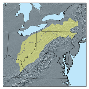
The Glaciated Allegheny Plateau is a special part of the Allegheny Plateau. It's called "glaciated" because huge sheets of ice, called glaciers, once covered this area. When the glaciers moved, they shaped the land, making it flatter and smoother compared to other parts of the plateau that the ice didn't touch.
This glaciated area is mostly found in the northern and western parts of the Allegheny Plateau. It stretches across parts of northeastern and southeastern Ohio. It also reaches into southern New York State and the central Susquehanna River basin.
How Glaciers Shaped the Land
Long, long ago, during the last ice age, glaciers covered parts of the Allegheny Plateau. These massive ice sheets slowly moved across the land. As they moved, they carved out valleys and smoothed down hills. This is why the Glaciated Allegheny Plateau has gentler slopes and is less rugged than the Unglaciated Allegheny Plateau.
Some very old glacier movements, from even before the last major ice age, also affected a small part of this plateau. These ancient ice movements left behind old soil and rocks that have been buried over a long time.
Important Cities
Two major cities located on the Glaciated Allegheny Plateau are Akron and Youngstown. These cities are in Ohio, within the area that was shaped by the glaciers.
 | Selma Burke |
 | Pauline Powell Burns |
 | Frederick J. Brown |
 | Robert Blackburn |


