Unglaciated Allegheny Plateau facts for kids
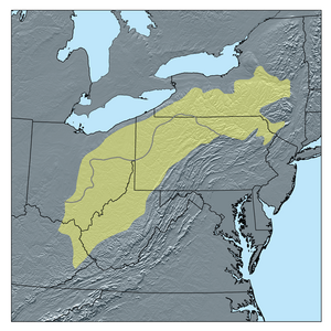
The Unglaciated Allegheny Plateau is a special land area in the eastern United States. It forms a big curve around southeastern Ohio, West Virginia, western Pennsylvania, and a small part of southwestern New York State.
This region is a type of landform called a dissected plateau. Imagine a flat area that has been cut into by rivers and streams over a very long time, creating hills and valleys. This plateau is made up of rocks like sandstone and shale, and it has many layers of coal hidden underground. What makes it "unglaciated" is that it was not covered by the huge ice sheets during the last ice age.
Contents
What Makes This Plateau Special?
The Unglaciated Allegheny Plateau is known for its rugged and beautiful scenery. It's a place where you can find ancient rock formations and deep river valleys.
Amazing Scenery: Hocking Hills
One of the most stunning and popular places in this region is the Hocking Hills area in southeast Ohio. It's a bit like the Red River Gorge in Kentucky, but smaller. Hocking Hills is famous for its tall cliffs, cool rock shelters (overhangs where people can find shelter), and beautiful waterfalls. It's a great spot for hiking and exploring nature.
Major Cities in the Plateau
The biggest city located within the Unglaciated Allegheny Plateau is Pittsburgh, Pennsylvania. This city is a major center for industry and culture in the region.
Rivers That Shaped the Land
Many important rivers flow through the Unglaciated Allegheny Plateau, helping to create its unique landscape.
The Ohio River and Its Path
The Ohio River is a very important river that cuts through the middle of the Unglaciated Allegheny Plateau. It generally flows from the north-northeast to the south-southwest.
Other Important Rivers
Other big rivers in this plateau include:
- The Muskingum River and Tuscarawas River in Ohio.
- The Youghiogheny River and Allegheny River in Pennsylvania.
- The Monongahela River and Kanawha River in West Virginia.
The Kanawha River is formed when two other rivers, the New River and the Gauley River, join together. These three rivers are famous for their incredibly deep and dramatic gorges, which are like giant canyons carved by the water over millions of years.
See also
- Geography of Appalachia
 | Delilah Pierce |
 | Gordon Parks |
 | Augusta Savage |
 | Charles Ethan Porter |


