
Gauley River facts for kids
Quick facts for kids Gauley River |
|
|---|---|

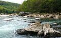
Sweet's Falls on the Gauley River
|
|
| Country | United States |
| State | West Virginia |
| Counties | Randolph, Webster, Nicholas, Fayette |
| Physical characteristics | |
| Main source | North Fork Gauley River Gauley Mountain, Pocahontas County, WV 4,000 ft (1,200 m) 38°25′42″N 80°10′22″W / 38.42833°N 80.17278°W |
| 2nd source | South Fork Gauley River Pocahontas County, WV 3,937 ft (1,200 m) 38°22′43″N 80°12′52″W / 38.37861°N 80.21444°W |
| 3rd source | Middle Fork Gauley River Pocahontas County, WV 3,844 ft (1,172 m) 38°23′21″N 80°11′29″W / 38.38917°N 80.19139°W |
| River mouth | Kanawha River Gauley Bridge, WV 660 ft (200 m) 38°09′42″N 81°11′47″W / 38.16167°N 81.19639°W |
| Basin features | |
| Tributaries | |
The Gauley River is a 105-mile-long (169 km) river located in West Virginia, United States. It is famous for its exciting whitewater rafting areas. The Gauley River eventually joins with the New River to form the larger Kanawha River. This river then flows into the Ohio River, making the Gauley part of the huge Mississippi River watershed.
Contents
Where the Gauley River Starts
The Gauley River begins high up in the Monongahela National Forest on Gauley Mountain. It actually starts as three smaller streams: the North, Middle, and South Forks. These streams flow through Pocahontas and Randolph counties before joining together in Webster County.
After its start, the river flows generally towards the southwest. It passes through Webster, Nicholas, and Fayette counties. Along its path, it flows by towns like Camden-on-Gauley and Summersville. Finally, it reaches Gauley Bridge, where it meets the New River. Together, they create the Kanawha River.
Rivers Joining the Gauley
Several other rivers flow into the Gauley River. These are called tributaries. Most of the Gauley's largest tributaries come from the east, flowing west to meet it.
- The Williams River flows through the Monongahela National Forest. It joins the Gauley in a rural part of Webster County.
- The Cranberry River also runs through the Monongahela National Forest. It empties into the Gauley in Nicholas County.
- The Cherry River first flows through the town of Richwood. It then joins the Gauley near Craigsville.
- The Meadow River flows through the town of Rainelle. It meets the Gauley at the border between Fayette and Nicholas counties.
Summersville Dam and Lake
In Nicholas County, the Gauley River is held back by a large structure called the Summersville Dam. This dam was built by the U.S. Army Corps of Engineers and creates Summersville Lake. Below the dam, you'll find the Gauley River National Recreation Area, a special place for outdoor fun.
Whitewater Rafting Adventures
The Gauley River is a very popular spot for whitewater rafting and kayaking. People who love boating use the river all year round. Commercial rafting companies also offer trips from spring to fall. The amount of water in the river changes a lot depending on rainfall and how much water is in Summersville Lake.
"Gauley Season" Releases
There's a special time of year called "Gauley Season." This starts on the Friday after Labor Day. During this season, the U.S. Army Corps of Engineers releases water from the Summersville Dam on purpose. These controlled releases are specifically for people to enjoy whitewater rafting.
"Gauley Season" lasts for six weekends in a row. The first five weekends are four days long (Friday through Monday), and the last one is Saturday and Sunday. The amount of water released during this time is usually between 2,400 and 2,800 cubic feet per second.
These special releases happen because of a law passed by the U.S. Congress. It was the first law in the U.S. to specifically say that a dam must release water for recreational whitewater activities. "Gauley Season" brings in millions of dollars each year to the local area. People who love paddling travel from all over the United States and even from other countries to experience it.
Gauley River History
The area around the Gauley River has some important history. On September 10, 1861, the Battle of Carnifex Ferry took place here during the American Civil War. The Union army won this battle.
The River's Name

The name "Gauley River" likely comes from the word "Gaul." This was a historical region in Europe, mostly where France is today. West Virginia was once part of New France, a French territory, before the French and Indian War. So, the name might mean "river of the Gauls."
In the past, Native American tribes had different names for the river. There were also different spellings of "Gaul" or "Gauley," and sometimes it was called "Falling Creek" or "Falls Creek."
Images for kids
-
Anglers fish for rainbow and brown trout on the Gauley River.
