Camden-on-Gauley, West Virginia facts for kids
Quick facts for kids
Camden-on-Gauley, West Virginia
|
|
|---|---|

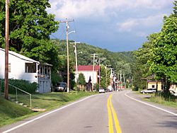
Central Camden-on-Gauley
|
|

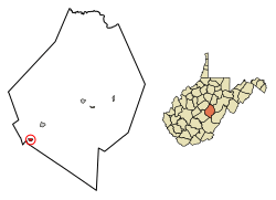
Location of Camden-on-Gauley in Webster County, West Virginia.
|
|
| Country | United States |
| State | West Virginia |
| County | Webster |
| Area | |
| • Total | 0.33 sq mi (0.86 km2) |
| • Land | 0.33 sq mi (0.84 km2) |
| • Water | 0.01 sq mi (0.02 km2) |
| Population
(2020)
|
|
| • Total | 126 |
| • Estimate
(2021)
|
124 |
| • Density | 446.15/sq mi (172.21/km2) |
| Time zone | UTC-5 (Eastern (EST)) |
| • Summer (DST) | UTC-4 (EDT) |
| ZIP code |
26208
|
| Area code(s) | 304 |
| FIPS code | 54-12436 |
| Website | https://local.wv.gov/CamdenOnGauley/Pages/default.aspx |
Camden-on-Gauley is a small town in Webster County, West Virginia, United States. It is located right next to the Gauley River. In 2020, about 126 people lived there.
The town got its name from Johnson N. Camden. He was a senator and owned many businesses near the Gauley River. The town was first called Lanes Bottom. But when it officially became a town in 1904, its name was changed to Camden-on-Gauley.
Contents
Where is Camden-on-Gauley Located?
Camden-on-Gauley is found at specific map coordinates: 38 degrees, 22 minutes, 8 seconds North and 80 degrees, 35 minutes, 47 seconds West. You can think of these as its exact address on a map.
How Big is the Town?
According to the United States Census Bureau, the town covers a total area of about 0.34 square miles (0.86 square kilometers). Most of this area, about 0.33 square miles (0.84 square kilometers), is land. A small part, about 0.01 square miles (0.02 square kilometers), is water.
Who Lives in Camden-on-Gauley?
| Historical population | |||
|---|---|---|---|
| Census | Pop. | %± | |
| 1910 | 263 | — | |
| 1920 | 283 | 7.6% | |
| 1930 | 435 | 53.7% | |
| 1940 | 373 | −14.3% | |
| 1950 | 373 | 0.0% | |
| 1960 | 301 | −19.3% | |
| 1970 | 243 | −19.3% | |
| 1980 | 236 | −2.9% | |
| 1990 | 171 | −27.5% | |
| 2000 | 157 | −8.2% | |
| 2010 | 169 | 7.6% | |
| 2020 | 126 | −25.4% | |
| 2021 (est.) | 124 | −26.6% | |
| U.S. Decennial Census | |||
Every ten years, the United States counts its population. This is called a census. The numbers above show how the population of Camden-on-Gauley has changed over many years.
Details from the 2010 Census
In the 2010 census, there were 169 people living in Camden-on-Gauley. These people lived in 70 different homes. Out of these homes, 48 were families.
The town had about 512 people per square mile. There were 87 housing units, which means 87 places where people could live. All the people living in the town were identified as White.
Households and Families
- Out of the 70 homes, 30% had children under 18 living there.
- Almost 46% of the homes were married couples living together.
- About 16% of homes had a female head of the house with no husband present.
- About 7% had a male head of the house with no wife present.
- About 31% of homes were not families, meaning individuals or unrelated people living together.
- Also, 31% of all homes had someone living alone. About 7% of these were people aged 65 or older.
- On average, about 2.41 people lived in each home. For families, the average was about 2.94 people.
Age and Gender in 2010
The average age of people in the town was 39.5 years.
- About 20% of residents were under 18 years old.
- About 8% were between 18 and 24 years old.
- About 32% were between 25 and 44 years old.
- About 24% were between 45 and 64 years old.
- About 15% were 65 years old or older.
When it came to gender, the population was almost evenly split. About 50.3% were male, and 49.7% were female.
See also
 In Spanish: Camden-on-Gauley (Virginia Occidental) para niños
 | James Van Der Zee |
 | Alma Thomas |
 | Ellis Wilson |
 | Margaret Taylor-Burroughs |

