
Cranberry River (West Virginia) facts for kids
Quick facts for kids Cranberry River |
|
|---|---|

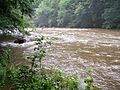
High water near Big Rock Campground in Monongahela National Forest
|
|
| Country | United States |
| State | West Virginia |
| Counties | Pocahontas, Webster, Nicholas |
| Physical characteristics | |
| Main source | South Fork Cranberry River Cranberry Mountain, Pocahontas County 3,890 ft (1,190 m) 38°12′48″N 80°13′14″W / 38.21333°N 80.22056°W |
| 2nd source | North Fork Cranberry River Black Mountain, Pocahontas County 4,364 ft (1,330 m) 38°14′03″N 80°14′32″W / 38.23417°N 80.24222°W |
| River mouth | Gauley River Woodbine 1,919 ft (585 m) 38°17′58″N 80°36′49″W / 38.29944°N 80.61361°W |
| Length | 24 mi (39 km) |
| Discharge (location 2) |
|
| Basin features | |
| Basin size | 74 sq mi (190 km2) |
The Cranberry River is a beautiful river in southeastern West Virginia, United States. It's a smaller stream that flows into the bigger Gauley River. The water from the Cranberry River eventually joins the Kanawha, Ohio, and mighty Mississippi Rivers!
The river got its name because many cranberry plants used to grow along its banks. It was also known as Cranberry Creek a long time ago.
Contents
Where Does the Cranberry River Flow?
The Cranberry River starts in Pocahontas County. It is formed when two smaller streams, the North Fork and the South Fork, join together.
The River's Forks
- The South Fork is about 9 miles (14 km) long. It begins on Cranberry Mountain. It flows through a special area called the Cranberry Glades Botanical Area.
- The North Fork starts about 2 miles (3.2 km) north on Black Mountain.
After these two forks meet, the Cranberry River flows for about 24 miles (39 km). It generally moves westward until it reaches the Gauley River near Craigsville.
Life Along the River
Most of the Cranberry River flows through land managed by the United States Forest Service. This means very few people live right along its banks. However, there are several places for visitors to enjoy. You can find campgrounds and picnic areas along the river.
Fishing in the Cranberry River
The Cranberry River and its smaller streams are known as some of the best places to fish for trout in the eastern United States.
Helping the Fish Thrive
Years ago, the number of fish in the river went down. This was because of something called acid rain, which made the water too acidic. Acid rain happens when pollution in the air mixes with rain.
To help the fish, especially trout, the West Virginia Division of Natural Resources started a special project. They set up "liming stations" on parts of the river. These stations add a material called lime to the water. Lime helps to make the water less acidic and more suitable for fish.
Thanks to these efforts, fish like brook trout are now doing much better in the river. Other fish, like smallmouth bass, have also returned and are increasing in numbers.
How Much Water Flows?
The Cranberry River carries a lot of water! Near Richwood, the river's average flow is about 233.6 cu ft/s (6.61 m3/s) each year. This is measured by the USGS.
The amount of water can change a lot. For example, in 1979, the river had a very high flow. In 1999, it had a much lower flow. The most water ever recorded flowing in one day was on March 21, 1984.
Images for kids
-
Cranberry River at the Woodbine Picnic Area after a heavy rain

