Meadow River facts for kids
Quick facts for kids Meadow River |
|
|---|---|

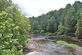
Meadow River at Russellville in July 2014
|
|
| Country | United States |
| State | West Virginia |
| Counties | Greenbrier, Nicholas |
| Physical characteristics | |
| Main source | Eagle Branch Little Sewell Mountain, Greenbrier County, WV 37°46′54″N 080°42′26″W / 37.78167°N 80.70722°W |
| 2nd source | Callahan Branch Bennett's Mountain, Greenbrier County, WV |
| River mouth | Gauley River Carnifex Ferry, WV 38°11′36″N 080°56′40″W / 38.19333°N 80.94444°W |
The Meadow River is a river located in West Virginia, United States. It is a branch, or "tributary," of the Gauley River. The Meadow River starts in Greenbrier County and ends in Nicholas County. It gets its name from the grassy, wet areas called "meadows" where it begins.
Contents
The River's Journey
The Meadow River starts when two smaller streams, Eagle Branch and Callahan Branch, join together. It generally flows from the southeast to the northwest. Along its path, it passes through towns like Rupert, Charmco, and Rainelle.
Streams Joining the Meadow River
Many other streams flow into the Meadow River, adding to its water. These include:
- Methodist Branch
- Otter Creek
- Little Clear Creek
- Big Clear Creek
- Mill Creek
- Laurel Creek
- Meadow Creek
- Brackens Creek
- Young's Creek
- Glade Creek
- Hendricks Creek
- Dogwood Creek
The river finally reaches its end where it flows into the Gauley River at Carnifex Ferry.
River Length and Area
The Meadow River flows for a total of 53 miles (85 km). Most of this journey is within the Meadow River Wildlife Management Area. The last 5 miles (8.0 km) of the river are part of the Gauley River National Recreation Area. The river drains water from an area of 365 square miles (950 km2).
Part of a Bigger System
The Meadow River is part of a much larger river system. Its waters flow into the Gauley River, then the New River, followed by the Kanawha River, and finally the Ohio River. All these rivers eventually lead to the mighty Mississippi River. This entire network of rivers and streams is called a watershed.
A Look Back in Time
In 1858, people thought about building a dam near where the town of Rainelle is today. This dam would have been located between Big Sewell and Laurel Mountains. However, the plan for this dam was never carried out, and it was not built.
Whitewater Adventures
The Meadow River is famous for its exciting whitewater rapids, especially for people who enjoy paddling.
Paddling Challenges Below Rainelle
A 15 miles (24 km) section of the river, from Rainelle to Russelville, has challenging rapids. These rapids are rated as Class III, Class IV, and even some Class V when the water is high. This means they are quite difficult and require skill.
After a calmer section of the river, it reaches the town of Nallen. Below Nallen, for about 5 miles (8.0 km), the river mostly has Class III and Class IV rapids. This section continues up to the U.S. 19 bridge.
The Most Difficult Section
The final part of the river, below the U.S. 19 bridge, is considered one of the most challenging whitewater rivers in West Virginia. This section is rated Class V+. This means it has a very steep drop and many rocks that are undercut (meaning they have hollow spaces underneath). Because of its extreme difficulty, this part of the river should only be attempted by very experienced whitewater paddlers who understand the risks and safety precautions.
Famous Rapids
Some of the well-known rapids in this challenging section include:
- Put In (Class III+)
- Rites of Passage (Class IV+)
- Hells Gates (Class 5.2)
- Brink of Disaster (Class 5.0)
- Coming Home Sweet Jesus (Class 5.3)
- Sieve City (Class 5.0)
- Heavy Water (Class IV)
- Lets Make a Deal (Class IV+)
- First and Second Island (Class V)
- Sliding Board (Class IV+)
- Double Undercut (Class 5.1)
 | John T. Biggers |
 | Thomas Blackshear |
 | Mark Bradford |
 | Beverly Buchanan |

