Poyntelle, Pennsylvania facts for kids
Quick facts for kids
Poyntelle, Pennsylvania
|
|
|---|---|
| Village of Poyntelle | |

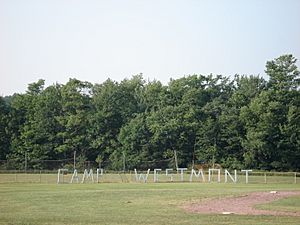
Camp Westmont in Poyntelle
|
|
| Country | United States |
| State | Pennsylvania |
| U.S. Congressional District | 10 |
| County | Wayne |
| School District | Wayne Highlands Region I |
| Magisterial District | 22-3-04 |
| Township | Preston |
| Named for | William Poyntell I |
| Elevation | 2,067 ft (630 m) |
| Time zone | UTC-5 (Eastern (EST)) |
| • Summer (DST) | UTC-4 (Eastern Daylight (EDT)) |
| ZIP codes | |
| Area code(s) | 570 |
| GNIS feature ID | 1204443 |
| FIPS code | 42-127-62600-57144 |
| Major Roads | |
| Waterways | Bone Pond, Equinunk Creek, Independent Lake, Johnson Creek, Lackawanna River (East Branch), Lackawaxen River (West Branch), Lake Lorain, Poyntelle Lake, Riley Creek |
Poyntelle (pronounced poy-NEL) is a small community, often called a village, located in Preston Township, Wayne County, Pennsylvania. It's nestled in the beautiful Lake Region of the Pocono Mountains, a popular area in the United States.
Contents
History of Poyntelle
Poyntelle was once a train stop for the New York, Ontario & Western Railway. Today, it is mostly known for its summer camps. Two well-known camps, Camp Westmont and Camp Poyntelle, are located here. These camps attract visitors from far away, making Poyntelle famous beyond its local area.
What is a Village in Pennsylvania?
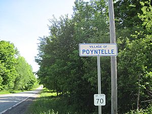
You might see signs that say "Village of Poyntelle" on the road. These signs are put up by the Pennsylvania Department of Transportation (PennDOT). In Pennsylvania, a "village" like Poyntelle is not a separate town with its own government. Instead, it's a community that is part of a larger area called a township.
This means Poyntelle doesn't have its own official borders or a separate town council. It's governed by Preston Township. Even though there are no official lines, people in the area generally agree on where Poyntelle begins and ends. Many local places are named after the village, which helps everyone know they are in Poyntelle.
Lakes and Creeks in Poyntelle
Poyntelle is home to several interesting natural features. You can find beautiful lakes like Bone Pond (also called Summit Lake), Independent Lake, Lake Lorain (also known as Five Mile Pond), and Poyntelle Lake (sometimes called Pointed Pond).
Several creeks also flow through the area. These include the Equinunk, Riley, and Johnson Creeks. Some small streams that form the West Branch of the Lackawaxen River also start in the southern part of Poyntelle.
Independent Lake, Bone Pond, and Lake Lorain are important because they are three of the four sources for the East Branch of the Lackawanna River. Lake Lorain is the highest lake in all of Wayne County. Poyntelle Lake feeds into the Equinunk Creek. Most lakes in this area get their water from natural springs at the bottom of the lake.
Roads Connecting Poyntelle
Poyntelle is located along Crosstown Highway, which is also known as PA-370. This is a main road that runs through the village. There are two other state roads here: Cribbs Road (PA-4031) and South Preston Road (PA-4033). All these main roads are paved.
There are also several smaller roads, called township roads, in Poyntelle. Some of these roads stay completely within the village, like Czapnik Road, Poyntelle Road, and Lake Lorain Road. Other township roads connect Poyntelle to nearby communities, such as Paluch Road and Clark Road. Many of these smaller township roads are unpaved, meaning they are dirt or gravel roads.
Finally, there are seven private roads in Poyntelle. These roads are used by people living in the community. Examples include Bone Pond Lane, Forest Road, and Lakeside Drive. All of these private roads are also unpaved.
Nearby Communities
 |
 |
|||
 | Misty Copeland |
 | Raven Wilkinson |
 | Debra Austin |
 | Aesha Ash |


