Walton (town), New York facts for kids
Quick facts for kids
Walton, New York
|
|
|---|---|

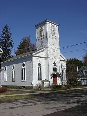
Christ Episcopal Church in Walton
|
|
| Country | United States |
| State | New York |
| County | Delaware |
| Government | |
| • Type | Town Council |
| Area | |
| • Total | 97.62 sq mi (252.83 km2) |
| • Land | 96.84 sq mi (250.81 km2) |
| • Water | 0.78 sq mi (2.02 km2) |
| Elevation | 1,228 ft (374 m) |
| Population
(2020)
|
|
| • Total | 5,270 |
| Time zone | Eastern (EST) |
| ZIP code |
13856
|
| Area code(s) | 607 |
| FIPS code | 36-025-78047 |
| GNIS feature ID | 979593 |
Walton is a town located in Delaware County, New York, United States. In 2020, about 5,270 people lived here. This town is in the west-central part of the county. It includes the village of Walton. The town is known as the "Scarecrow Capital of the World."
Walton was created in 1797 from the town of Franklin. The first people settled here in 1785. This early settlement was near where the village of Walton is today.
Contents
Walton's Location and Land
Walton is in the west-central part of Delaware County. It sits on both sides of the West Branch Delaware River. The town covers a total area of about 97.6 square miles (252.8 square kilometers). Most of this area, about 96.8 square miles (250.8 square kilometers), is land. The rest, about 0.8 square miles (2.0 square kilometers), is water.
Population Changes in Walton
| Historical population | |||
|---|---|---|---|
| Census | Pop. | %± | |
| 1820 | 1,432 | — | |
| 1830 | 1,672 | 16.8% | |
| 1840 | 1,846 | 10.4% | |
| 1850 | 2,271 | 23.0% | |
| 1860 | 2,740 | 20.7% | |
| 1870 | 3,216 | 17.4% | |
| 1880 | 3,544 | 10.2% | |
| 1890 | 4,543 | 28.2% | |
| 1900 | 4,869 | 7.2% | |
| 1910 | 5,088 | 4.5% | |
| 1920 | 5,425 | 6.6% | |
| 1930 | 5,111 | −5.8% | |
| 1940 | 5,220 | 2.1% | |
| 1950 | 5,724 | 9.7% | |
| 1960 | 5,753 | 0.5% | |
| 1970 | 5,882 | 2.2% | |
| 1980 | 5,839 | −0.7% | |
| 1990 | 5,953 | 2.0% | |
| 2000 | 5,607 | −5.8% | |
| 2010 | 5,576 | −0.6% | |
| 2020 | 5,270 | −5.5% | |
| U.S. Decennial Census | |||
The population of Walton has changed over many years. The table above shows how many people lived in the town during different census years.
In 2000, there were 5,607 people living in Walton. These people lived in 2,391 households. A household is a group of people living together. About 1,570 of these households were families.
The average household in Walton had about 2.33 people. The average family had about 2.85 people.
Age Groups in Walton
In 2000, the population of Walton was spread across different age groups:
- 23.5% were under 18 years old.
- 6.4% were between 18 and 24 years old.
- 25.7% were between 25 and 44 years old.
- 26.5% were between 45 and 64 years old.
- 17.9% were 65 years old or older.
The median age in Walton was 42 years. This means half the people were younger than 42, and half were older.
Well-Known People from Walton
Walton has been home to several notable individuals:
- Hobart M. Cable – A politician from Massachusetts and a person who made pianos.
- Jeri Laber – One of the people who helped start Human Rights Watch, an organization that protects human rights.
- Everett De Morier – A writer known for his humor and novels.
- William B. Ogden (1805-1877) – He was the very first mayor of Chicago. He served from 1837 to 1838.
Leaders of Walton Town
The town of Walton has elected officials who help run things.
- Town Supervisor: Joseph M. Cetta
- Town Clerk/Tax Collector Registrar of Vital Statistics: Ronda Williams
- Town Board Members:
- Kevin Armstrong
- Len Govern
- Patty Wood
- Luis Rodriguez
Places and Areas in Walton Town
The Town of Walton includes several smaller communities and natural features:
- Bear Spring Mountain – A high area located south of the village of Walton.
- Beerston – A small community located south-southwest of Walton.
- Colchester Mountain – A high area located northeast of Starkweather Hill.
- Dunk Hill – A high area located north-northeast of the village of Walton.
- Houck Mountain – A high area located south of Bear Spring Mountain.
- Launt Pond – A small lake located south of Mount Holly.
- Loomis – A small community located northwest of Walton.
- Loomis Mountain – A high area located northeast of Loomis.
- Mount Holly – A high area located east-southeast of the village of Walton.
- Northfield – A small community located north-northwest of Walton.
- Oak Ridge Pond – A small lake located west-northwest of Russ Gray Pond.
- Pine Hill – A high area located east-northeast of the village of Walton.
- Pines Brook Ridge – A ridge (a long, narrow hill) located northwest of the village of Walton.
- Pinesville – A small community located west-southwest of Walton.
- Russ Gray Pond – A small lake located west of Launt Pond.
- South Mountain – A high area located south of the village of Walton.
- Starkweather Hill – A high area located southeast of Mount Holly.
- Teed Pond – A small lake located west of Northfield.
- Walton – This is the main village within the town. It is in the center of the town, along the West Branch Delaware River.
- Walton Mountain – A high area located west of the village of Walton.
See also
 In Spanish: Walton (pueblo) para niños
 | William M. Jackson |
 | Juan E. Gilbert |
 | Neil deGrasse Tyson |


