Tompkins, New York facts for kids
Quick facts for kids
Tompkins, New York
|
|
|---|---|

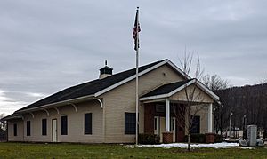
Town hall, in Trout Creek
|
|
| Country | United States |
| State | New York |
| County | Delaware |
| Government | |
| • Type | Town Council |
| Area | |
| • Total | 104.45 sq mi (270.52 km2) |
| • Land | 98.13 sq mi (254.16 km2) |
| • Water | 6.31 sq mi (16.35 km2) |
| Elevation | 1,155 ft (352 m) |
| Population
(2020)
|
|
| • Total | 1,290 |
| Time zone | UTC-5 (Eastern (EST)) |
| • Summer (DST) | UTC-4 (EDT) |
| ZIP code |
13754
|
| FIPS code | 36-025-74111 |
| GNIS feature ID | 0979549 |
Tompkins is a small town located in Delaware County, New York, in the United States. In 2020, about 1,290 people lived there.
The town got its name from Daniel D. Tompkins. He was an important person in New York's history. Daniel D. Tompkins served as the fourth governor of New York. He was also the sixth vice president of the United States. Tompkins is located in the western part of Delaware County.
History of Tompkins
The town of Tompkins was first created in 1806. It was formed from a part of another town called Franklin. Later, in 1880, the western part of Tompkins was used to create a new town. This new town was named Deposit.
Geography of Tompkins
Tompkins covers a total area of about 270.5 square kilometers (104.5 square miles). Most of this area is land, about 254.2 square kilometers (98.1 square miles). The rest, about 16.4 square kilometers (6.3 square miles), is water.
A large body of water, the Cannonsville Reservoir, is located in the middle of the town. This reservoir is part of the West Branch Delaware River.
People of Tompkins
| Historical population | |||
|---|---|---|---|
| Census | Pop. | %± | |
| 1820 | 1,206 | — | |
| 1830 | 1,774 | 47.1% | |
| 1840 | 2,035 | 14.7% | |
| 1850 | 3,022 | 48.5% | |
| 1860 | 3,589 | 18.8% | |
| 1870 | 4,046 | 12.7% | |
| 1880 | 2,534 | −37.4% | |
| 1890 | 2,626 | 3.6% | |
| 1900 | 2,482 | −5.5% | |
| 1910 | 2,127 | −14.3% | |
| 1920 | 1,737 | −18.3% | |
| 1930 | 1,665 | −4.1% | |
| 1940 | 1,642 | −1.4% | |
| 1950 | 1,680 | 2.3% | |
| 1960 | 1,463 | −12.9% | |
| 1970 | 905 | −38.1% | |
| 1980 | 968 | 7.0% | |
| 1990 | 994 | 2.7% | |
| 2000 | 1,105 | 11.2% | |
| 2010 | 1,247 | 12.9% | |
| 2020 | 1,290 | 3.4% | |
| U.S. Decennial Census | |||
In 2000, there were 1,105 people living in Tompkins. These people lived in 445 households, and 315 of these were families. The town had about 11.2 people per square mile. There were 768 homes in the area.
Most of the people living in Tompkins were White (98.55%). A small number were African American (0.81%) or Native American (0.09%). Some people were from other backgrounds. About 1.18% of the population was Hispanic or Latino.
About 28.5% of households had children under 18 living with them. Most households (58.2%) were married couples. About 24.5% of households were single people living alone. About 11.9% of these single people were 65 years or older.
The average household had 2.46 people. The average family had 2.90 people.
The population of Tompkins is spread out by age. About 23.1% were under 18 years old. About 25.3% were between 25 and 44 years old. The median age in the town was 42 years. This means half the people were younger than 42 and half were older.
The average income for a household in Tompkins was $35,227. For families, the average income was $38,583. About 8.9% of the population lived below the poverty line. This included 6.4% of those under 18 and 17.3% of those 65 or older.
Places in Tompkins
Here are some of the smaller communities and important places you can find in the town of Tompkins:
- Apex – A small community located southwest of Rock Rift.
- Cannonsville Reservoir – A large water reservoir on the West Branch Delaware River.
- Cleaver – A small community located northwest of Rock Rift.
- Islamberg – A community near Deposit. It was started by Syed Mubarik Ali Shah Gilani.
- Kelsey – A small community located southwest of Apex.
- Rock Rift – A small community located east of the Cannonsville Reservoir.
- Trout Creek – A small community located northwest of Cleaver.
See also
 In Spanish: Tompkins (Nueva York) para niños
 | May Edward Chinn |
 | Rebecca Cole |
 | Alexa Canady |
 | Dorothy Lavinia Brown |


